

125 years of science for America: 1879-2004
Indian Ocean Earthquake Triggers Deadly Tsunami
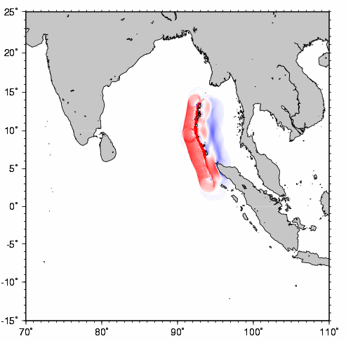
The tsunami arrived in northern Sumatra approximately 1/2 hour after the earthquake, in Thailand approximately 1 1/2 to 2 hours after the earthquake, and in Sri Lanka approximately 2 to 3 hours after the earthquake. According to initial modeling and eyewitness accounts, areas east of the earthquake rupture, or "generation area," were first affected by a negative wave (drawdown of water and retreat from shore before a rise in water), whereas areas west of the generation area were first affected by a positive wave (no drawdown or retreat of water before the first tsunami wave hit). Maximum wave heights estimated from media reports are Sumatra, 10 to 15 m; Sri Lanka, 5 to 10 m; India, 5 to 6 m; Andaman Islands, 5 m; Thailand, 3 to 5 m; and Kenya, 2 to 3 m. Some energy from the tsunami "leaked" into adjoining oceans, producing sea-level fluctuations at many places around the world (see West Coast/Alaska Tsunami Warning Center).
Post-Tsunami Field SurveysBy December 31, 2004, six international teams (including Japanese and American teams) had been formed to document the magnitude and effects of the tsunami before the evidence is destroyed. Typically, such teams arrive in the affected areas about one to three weeks after the tsunami occurs. Because this was the largest tsunami in more than 40 years and the area affected is very large, there could be as many as a dozen international teams investigating the tsunami. USGS oceanographer Bruce Jaffe and USGS geologist Bob Morton traveled to Sri Lanka from January 7 to 16 with an international team funded by the National Science Foundation and the USGS to examine inundation areas, estimate wave heights, determine the tsunami's precise arrival time, scour the area for geologic evidence and sedimentary deposits, and examine structural damage. As of this writing, the USGS had also been invited to have scientists participate in post-tsunami surveys in India, Thailand, and Sumatra.Ideally, post-tsunami surveys will include both a quick response focusing on ephemeral evidence and a later response (possibly in February or March) focusing on tsunami sedimentation and erosion. The quick response will include measurements of water levels, inundation distances (horizontal distance from the shoreline to the farthest inland reach of the tsunami), and indicators of the tsunami's flow direction and flow velocity. The later response will focus on the sediment deposited by the tsunami: whether it has characteristics that reflect those of the tsunami itself, such as its height, power, and extent; how much of the sediment is likely to be preserved in the geologic record; and how much is likely to be eroded away. The more we learn about sedimentary deposits from modern tsunamis, the more accurately we can identify and decipher sedimentary deposits from ancient tsunamis. Because scientists cannot yet predict when a tsunami will occur, learning to read a geologic record of past tsunamis may be one of the only ways to assess future risk. USGS scientists have conducted such studies of sediment deposited by recent tsunamis in Papua New Guinea (tsunami of 1998, see Preliminary Analysis of Sedimentary Deposits from the 1998 PNG Tsunami) and Peru (tsunami of 2001, see Preliminary Analysis of Sedimentary Deposits from the June 23, 2001 Peru Tsunami). They are working to determine how sediment layers deposited by tsunamis differ from those deposited by large storms, such as hurricanes, to aid identification of tsunami deposits in the geologic record (see Sound Waves article "Group Aims to Distinguish Tsunami Deposits from Large-Storm Deposits in the Geologic Record"). Tsunami Information on the WebMany Web sites have information about the Indian Ocean tsunami and tsunamis in general. Here are a few particularly useful ones:
|
Dec. 2004 / Jan. 2005
in this
issue: cover story:
Indian Ocean Tsunami |
||||||||||||||||||||||||||||||||||||||


http://soundwaves.usgs.gov/2005/01/


 U. S. Department of the Interior | U.S. Geological Survey
Sound Waves Monthly Newsletter
email Feedback | USGS privacy statement | Disclaimer | Accessibility
This page is http://soundwaves.usgs.gov/2005/01/index.html
Updated May 06, 2014 @ 02:12 PM (JSS)

|
|||||||||
Indian Ocean Earthquake Triggers Deadly Tsunami
Post-Tsunami Field SurveysBy December 31, 2004, six international teams (including Japanese and American teams) had been formed to document the magnitude and effects of the tsunami before the evidence is destroyed. Typically, such teams arrive in the affected areas about one to three weeks after the tsunami occurs. Because this was the largest tsunami in more than 40 years and the area affected is very large, there could be as many as a dozen international teams investigating the tsunami. USGS oceanographer Bruce Jaffe and USGS geologist Bob Morton traveled to Sri Lanka from January 7 to 16 with an international team funded by the National Science Foundation and the USGS to examine inundation areas, estimate wave heights, determine the tsunami's precise arrival time, scour the area for geologic evidence and sedimentary deposits, and examine structural damage. As of this writing, the USGS had also been invited to have scientists participate in post-tsunami surveys in India, Thailand, and Sumatra.Ideally, post-tsunami surveys will include both a quick response focusing on ephemeral evidence and a later response (possibly in February or March) focusing on tsunami sedimentation and erosion. The quick response will include measurements of water levels, inundation distances (horizontal distance from the shoreline to the farthest inland reach of the tsunami), and indicators of the tsunami's flow direction and flow velocity. The later response will focus on the sediment deposited by the tsunami: whether it has characteristics that reflect those of the tsunami itself, such as its height, power, and extent; how much of the sediment is likely to be preserved in the geologic record; and how much is likely to be eroded away. The more we learn about sedimentary deposits from modern tsunamis, the more accurately we can identify and decipher sedimentary deposits from ancient tsunamis. Because scientists cannot yet predict when a tsunami will occur, learning to read a geologic record of past tsunamis may be one of the only ways to assess future risk. USGS scientists have conducted such studies of sediment deposited by recent tsunamis in Papua New Guinea (tsunami of 1998, see Preliminary Analysis of Sedimentary Deposits from the 1998 PNG Tsunami) and Peru (tsunami of 2001, see Preliminary Analysis of Sedimentary Deposits from the June 23, 2001 Peru Tsunami). They are working to determine how sediment layers deposited by tsunamis differ from those deposited by large storms, such as hurricanes, to aid identification of tsunami deposits in the geologic record (see Sound Waves article "Group Aims to Distinguish Tsunami Deposits from Large-Storm Deposits in the Geologic Record"). Tsunami Information on the WebMany Web sites have information about the Indian Ocean tsunami and tsunamis in general. Here are a few particularly useful ones:
|
| |||||||||||||||||||||||||||||||||||||||
in this issue:
Indian Ocean Tsunami |
Sound Waves Monthly Newsletter
email Feedback | USGS privacy statement | Disclaimer | Accessibility
This page is http://soundwaves.usgs.gov/2005/01/index.html
Updated May 06, 2014 @ 02:12 PM (JSS)
Keine Kommentare:
Kommentar veröffentlichen