Powered By Blogger

Sonntag, 26. Februar 2017

THE INTERNATIONAL CHARTER ON SPACE AND MAJOR DISASTERS


International Charter on Space and Major Disasters

From Wikipedia, the free encyclopedia
The International Charter "Space and Major Disasters" is a non-binding charter which provides for the charitable and humanitarian retasked acquisition of and transmission of space satellite data to relief organizations in the event of major disasters. Initiated by the European Space Agency and the French space agency CNES after the UNISPACE III conference held in Vienna, Austria in July 1999, it officially came into operation on November 1, 2000 after the Canadian Space Agency signed onto the charter on October 20, 2000. Their space assets were then, respectively, ERS and ENVISAT, SPOT and Formosat, and RADARSAT.
The assorted satellite assets of various corporate, national, and international space agencies and entities provide for humanitarian coverage which is wide albeit contingent. First activated for floods in northeast France in December 2001,[1] the Charter has since brought space assets into play for numerous earthquakes, oil spills, forest fires, tsunamis, major snowfalls, volcanic eruptions, hurricanes and landslides,[2][3] and furthermore (and unusually) for the search for Malaysia Airlines Flight 370[4] and for the 2014 West Africa Ebola outbreak.[5] As of 2015 fifteen space agencies are signatories; dozens of satellites are available with resolutions ranging from 8 km per pixel to about 0.3048 m per pixel.[6]

Successive signatories and satellite assets

As of 2012 the live satellites and their instrumentalities were: The high resolution and very high resolution radar sensors of ENVISAT (decommissioned in April), RISAT-1, RADARSAT-1 & 2, TerraSAR-X and TanDEM-X; the high resolution and very high resolution optical sensors of SPOT satellites4 & 5, Pleiades, Landsat 5 & 7, PROBA1, UK-DMC 2, KOMPSAT-2, IRS-P5, Resourcesat-2, Oceansat-2, Cartosat-2, IMS-1, and RapidEye; the medium and low resolution optical sensors of POES, GOES, and SAC-C. Furthermore, specific agreements with other entities, including corporations, allow the Charter access to additional products of high and very high resolution from satellites such as the Formosat series, GeoEye, IKONOS, QuickBird, and WorldView.[8]
In 2014 the charter was activated 41 times for disasters in 30 countries. In that year the live satellites and their instrumentalities included: The high and very high resolution radar sensors of Risat-1, RADARSAT-2, TerraSAR-X, and TanDEM-X and Sentinel-1A; the optical high and very high resolution sensors of UK-DMC 2, Landsat 7 and 8, SPOT series 5, 6, and 7, Pléiades 1A and 1B, PROBA 1, SJ-9A, GF-1, KOMPSAT-2, IRS-P5 (Cartosat-1), Cartosat-2, Resourcesat-2, Oceansat-2, RapidEye, Kanopus-V, and Resurs-P, and the HDTV camera mounted the Kibo module of the International Space Station; and the medium and low optical sensors of POES, GOES, FY-3C, the Metop series, the first two Meteosat generations, and Meteor-M. Specific agreements with other entities allow for the usage of the Formosat, GeoEye, IKONOS, QuickBird, and WorldViews satellites, which have high and very high reolution. Archival data from defunct satellites such as ALOS, ENVISAT, ERS, CBERS, IRS-1C, Astra 1D, IRS P4, P6, IMS-1, RADARSAT-1, SAC-C, SPOT 1-3 & 4, UK-DMC, Landsat-5 and NigeriaSat are also available.[11]

Major events resulting in activation

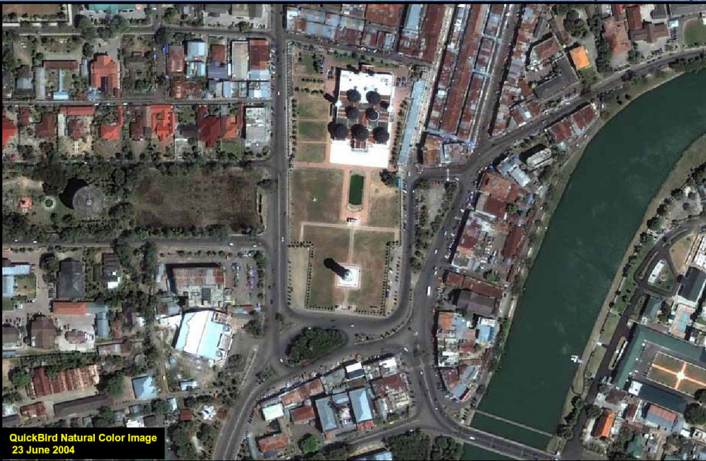
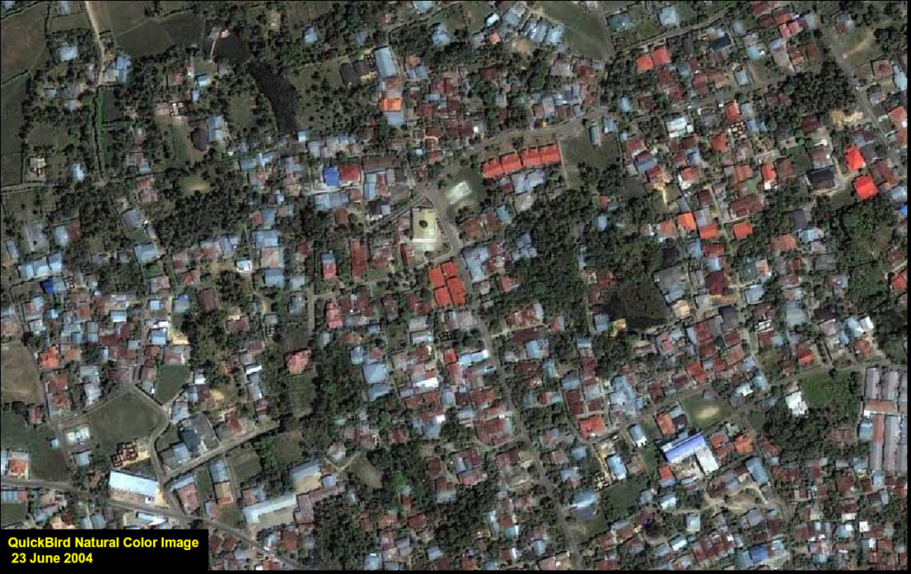
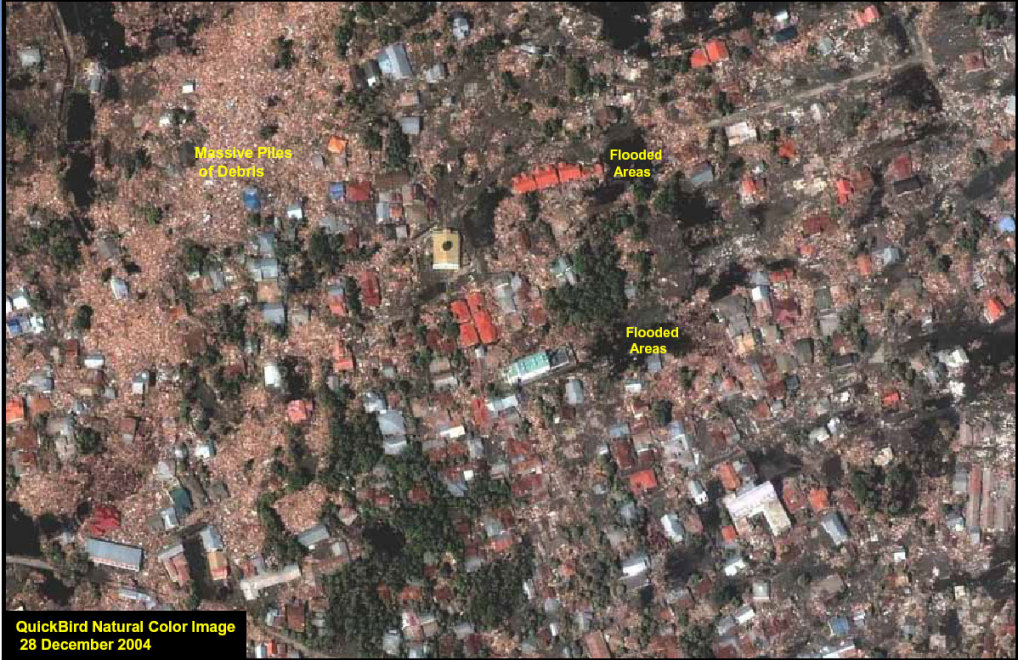
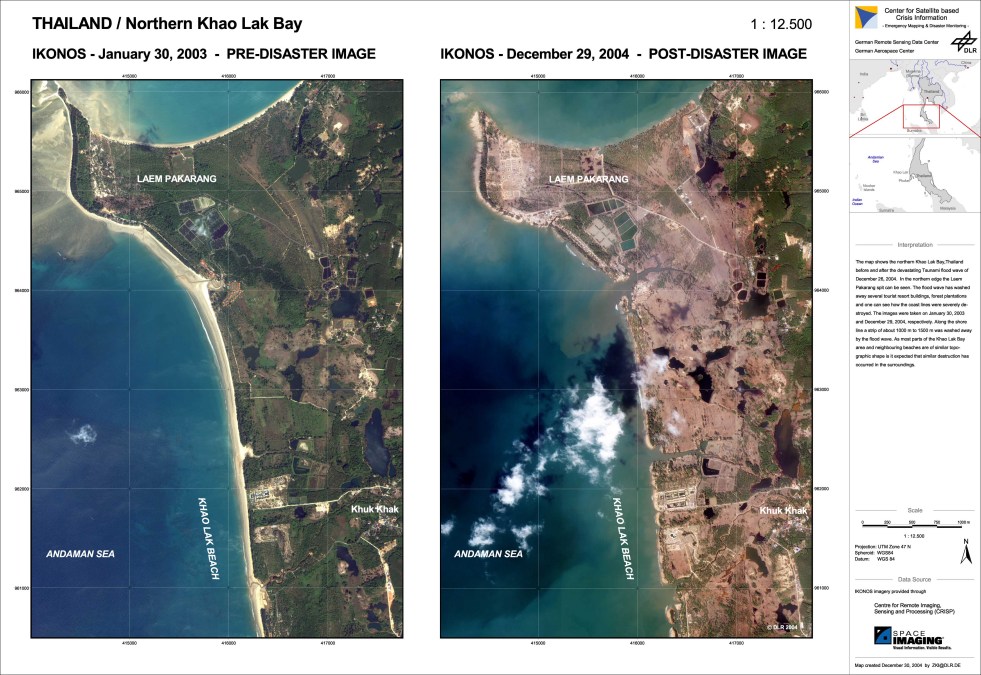
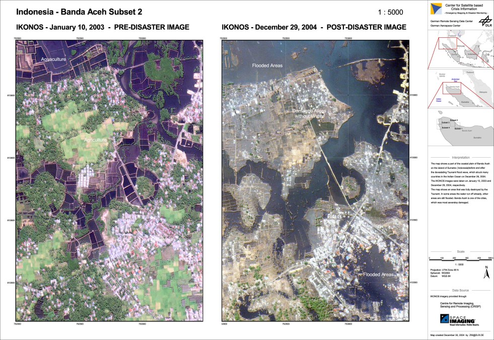
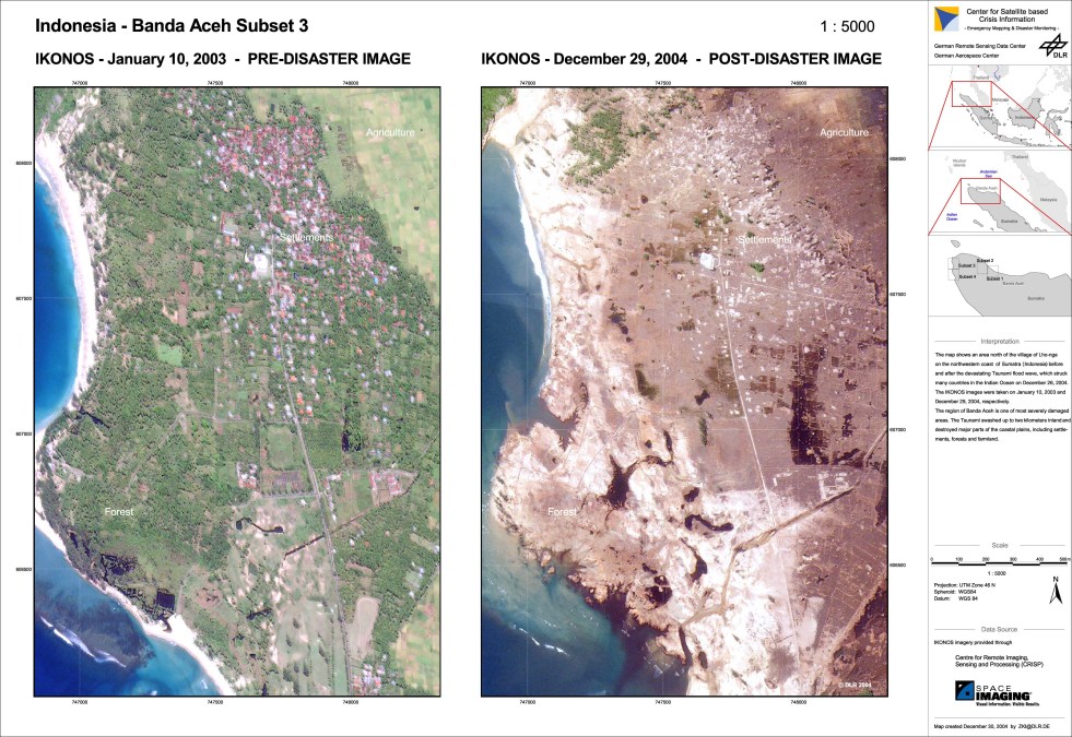
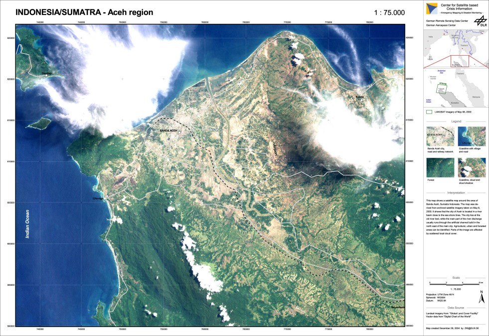
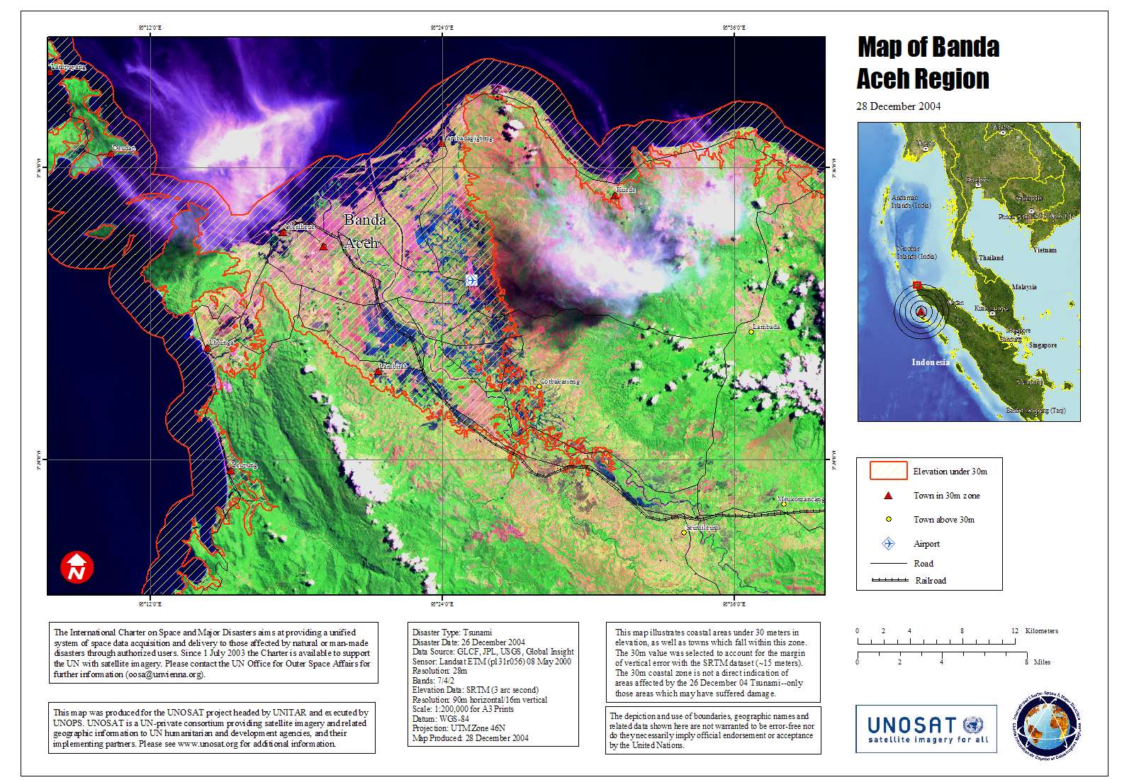
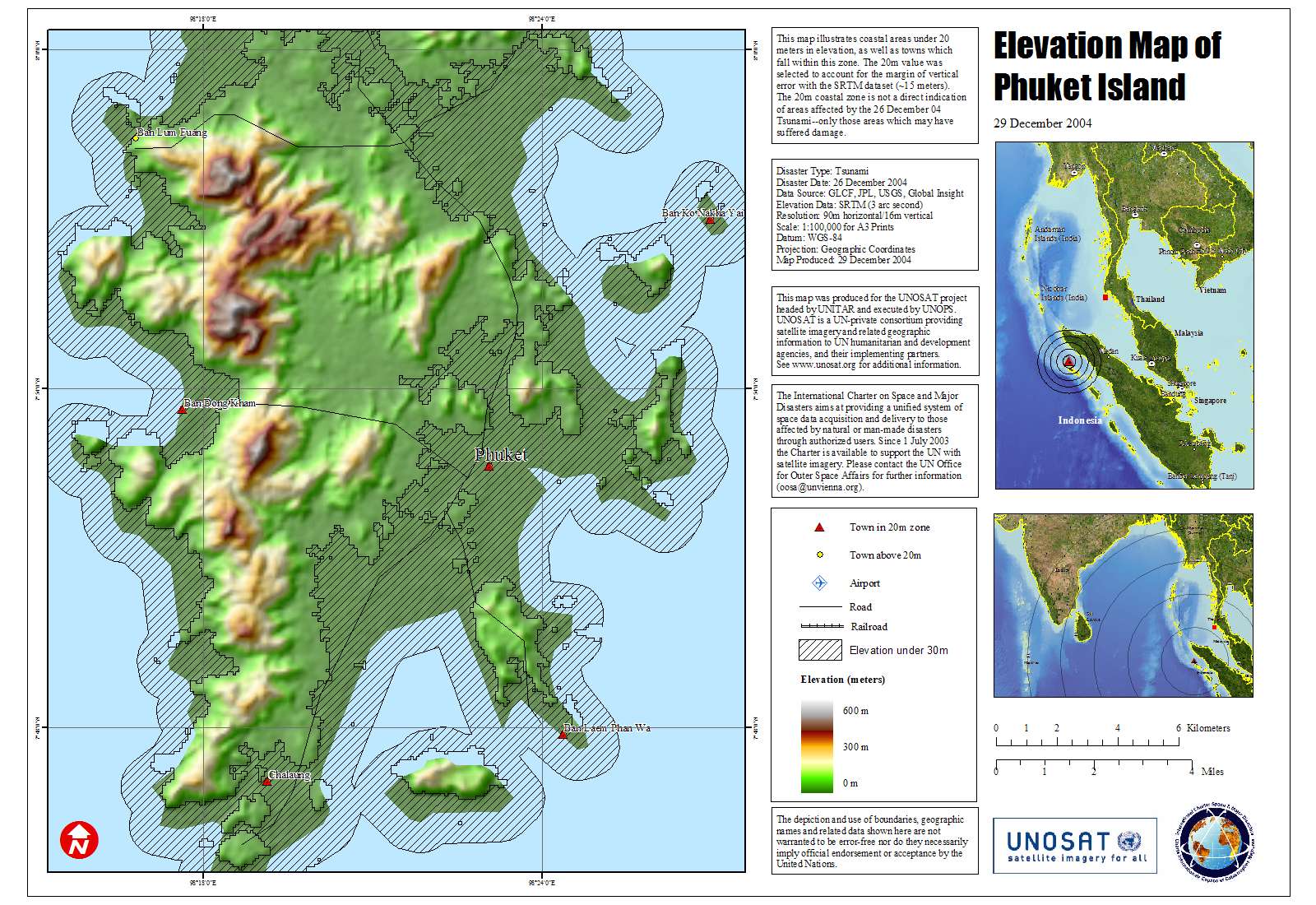
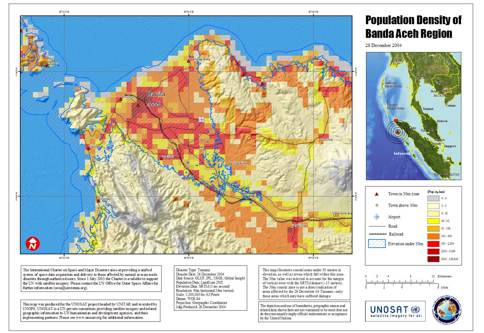
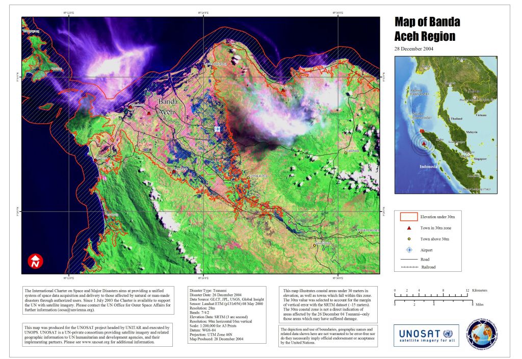
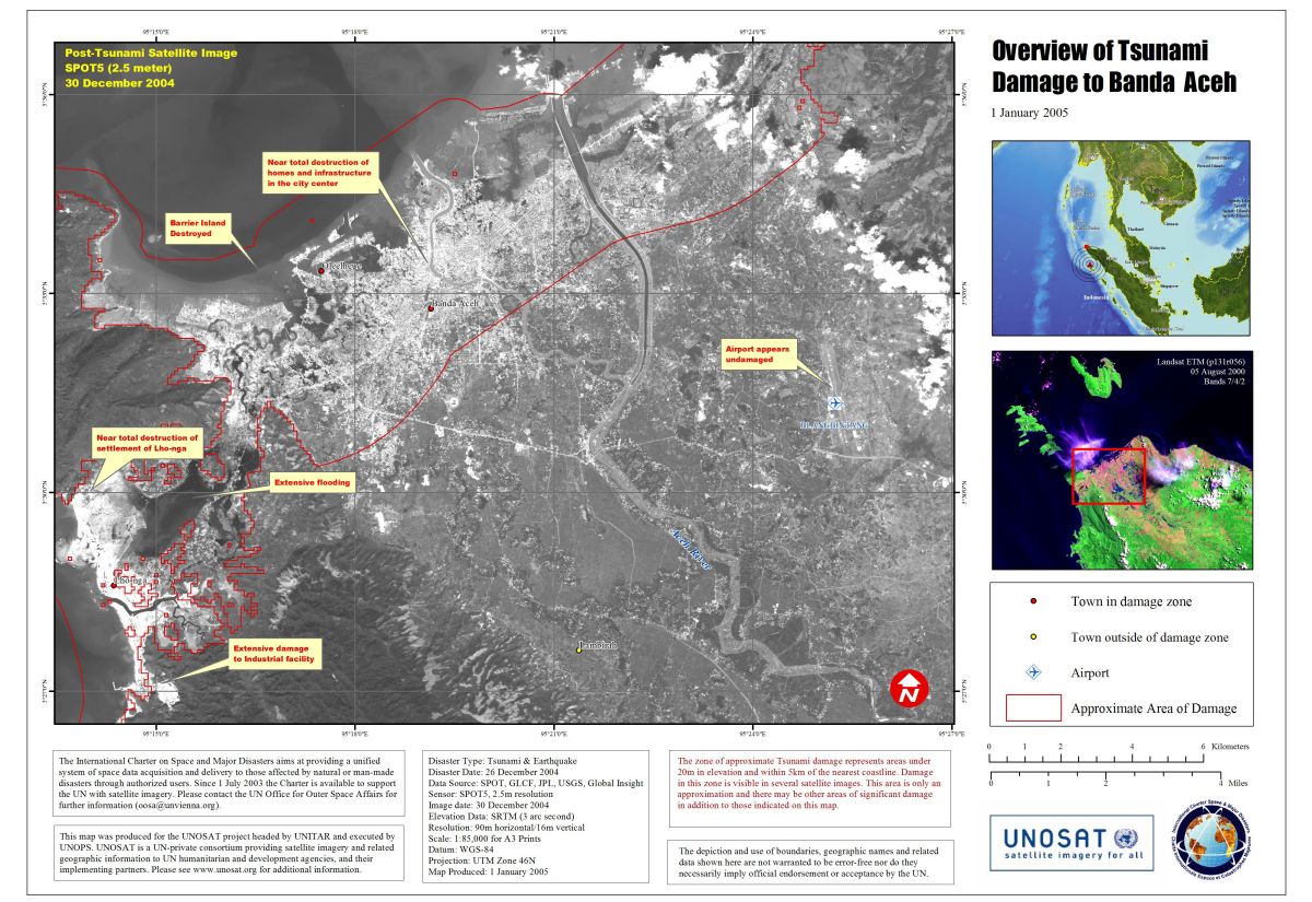
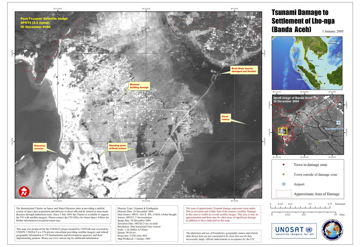
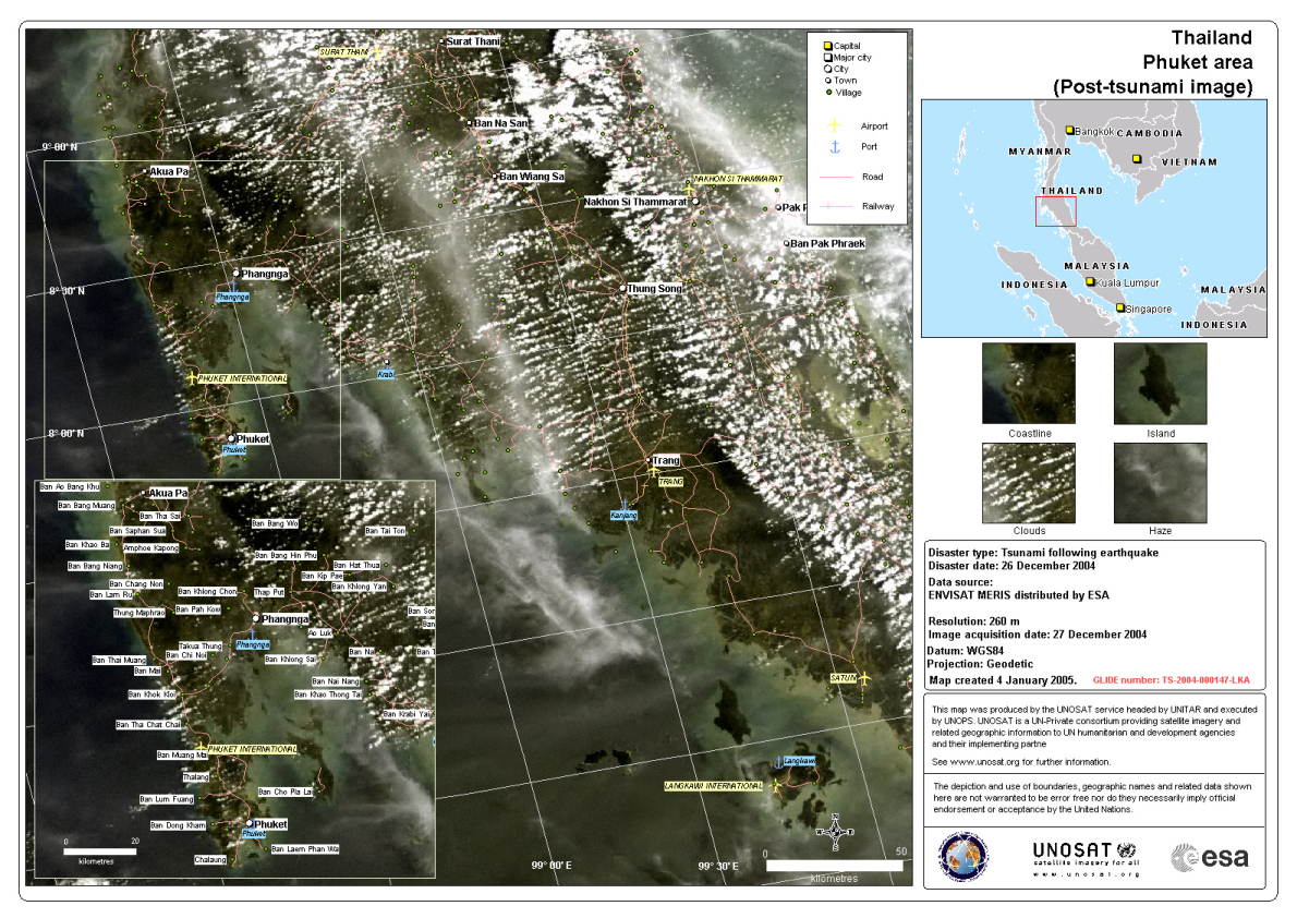
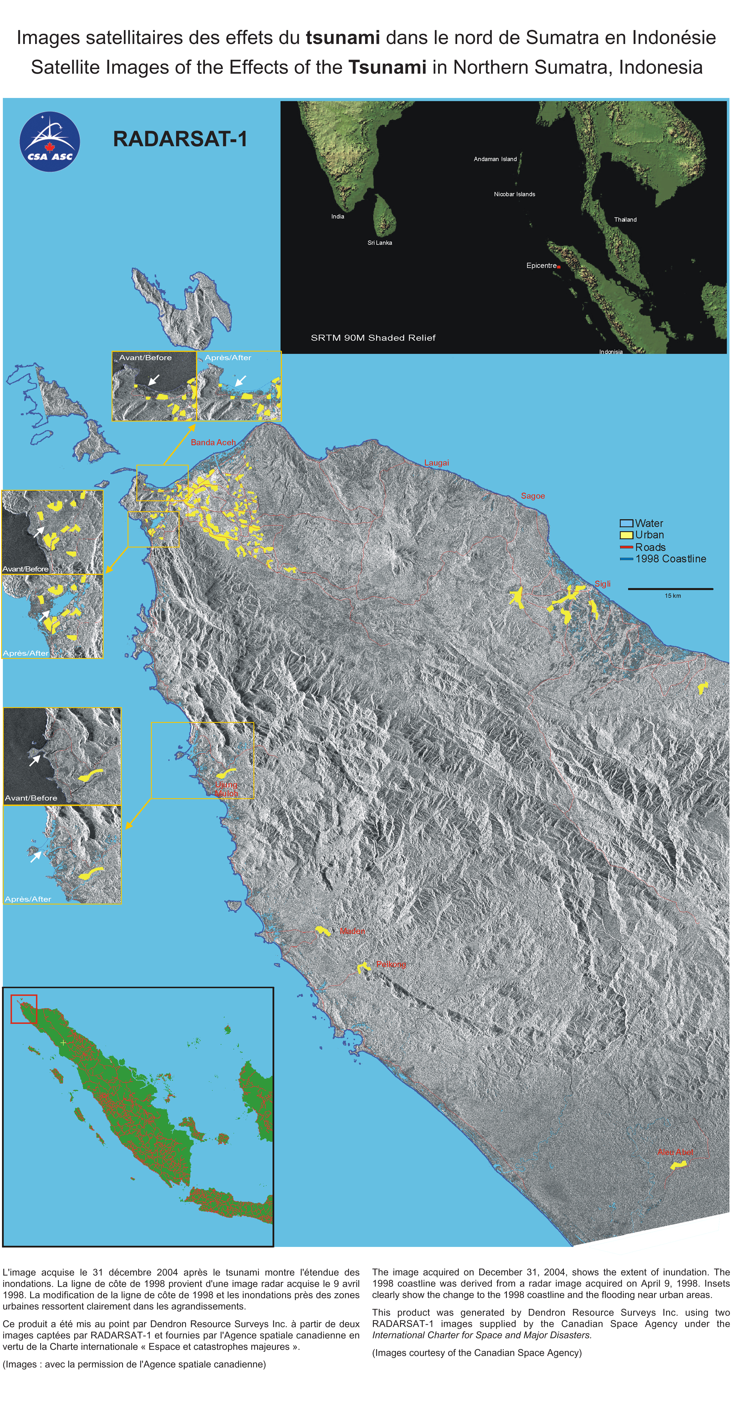
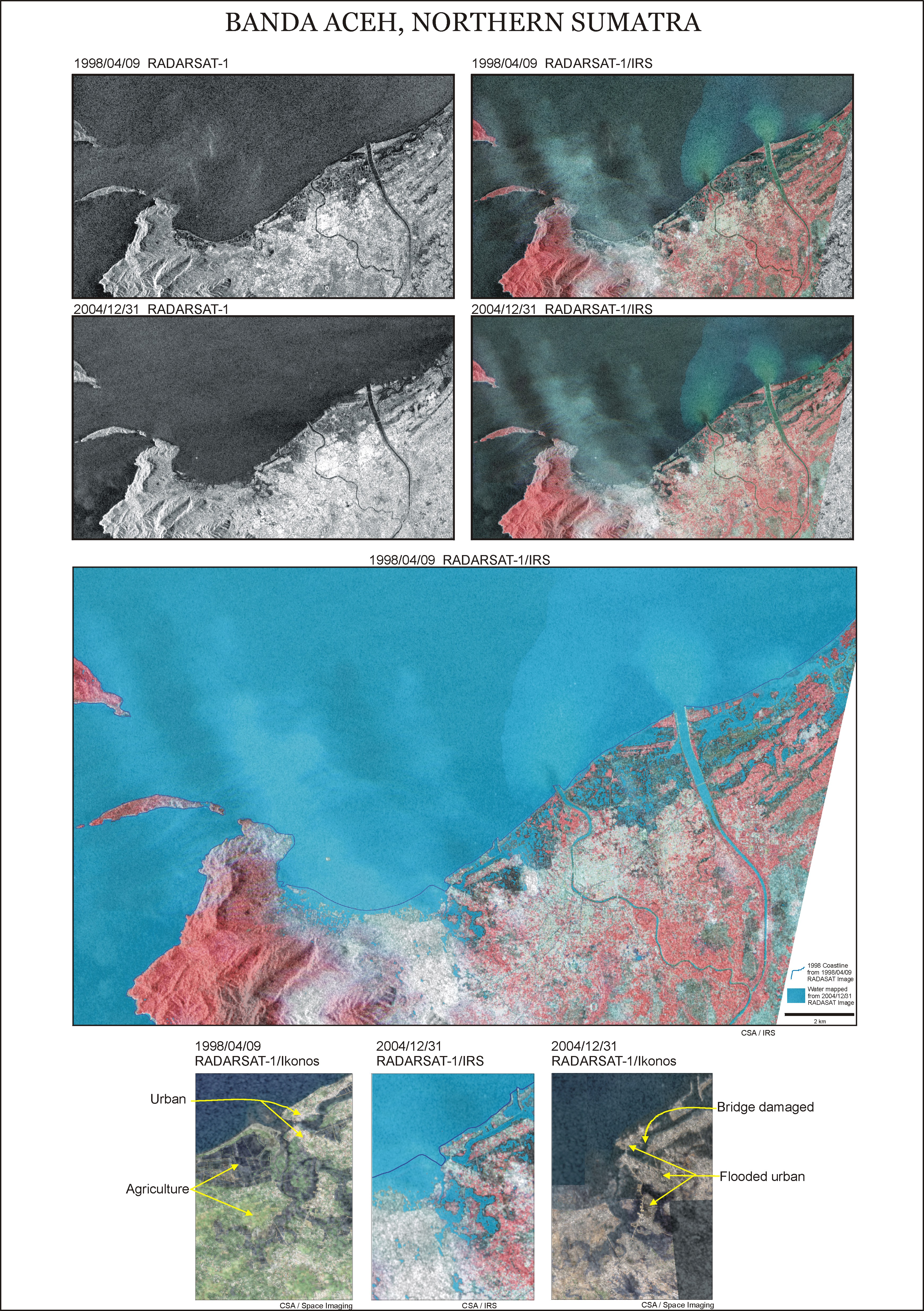
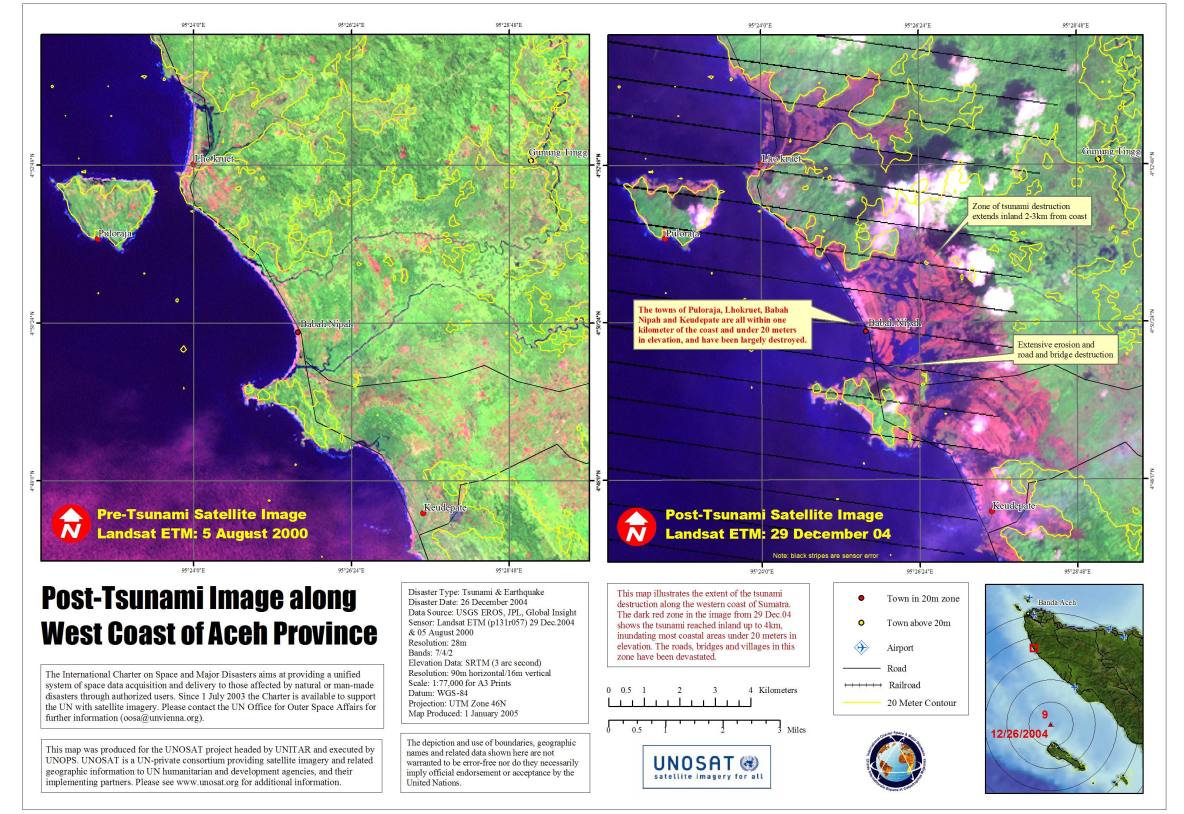
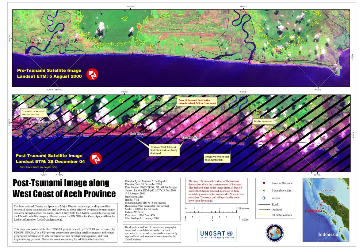
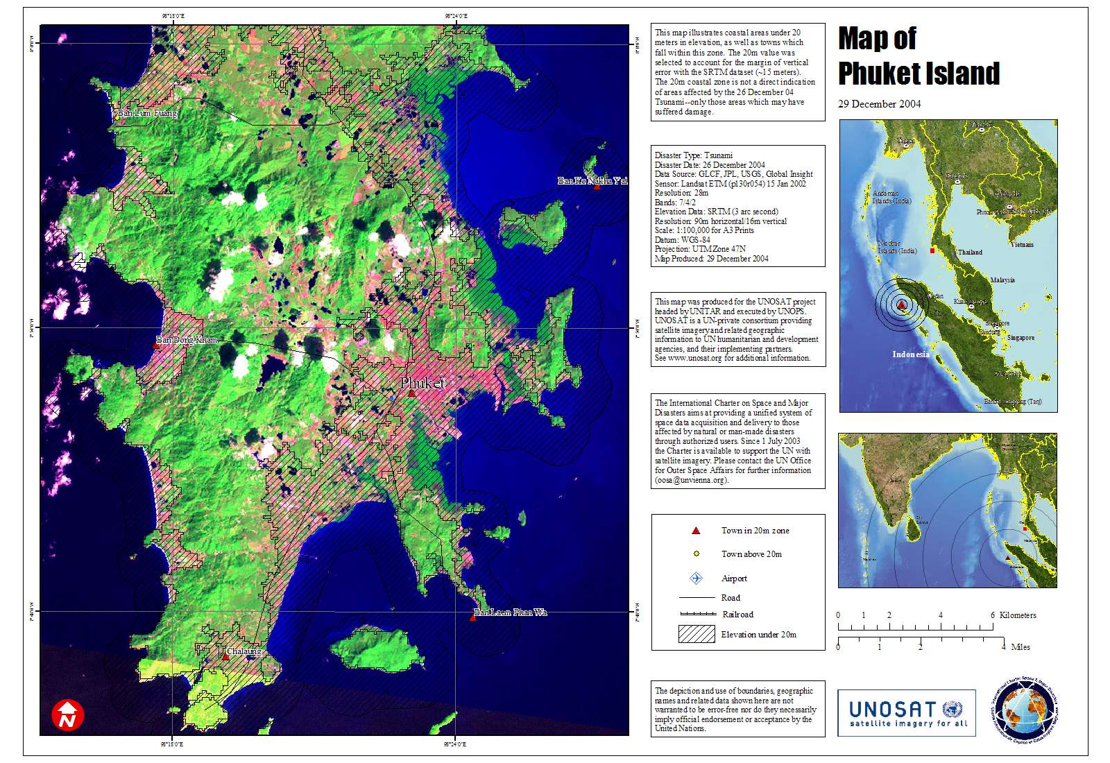
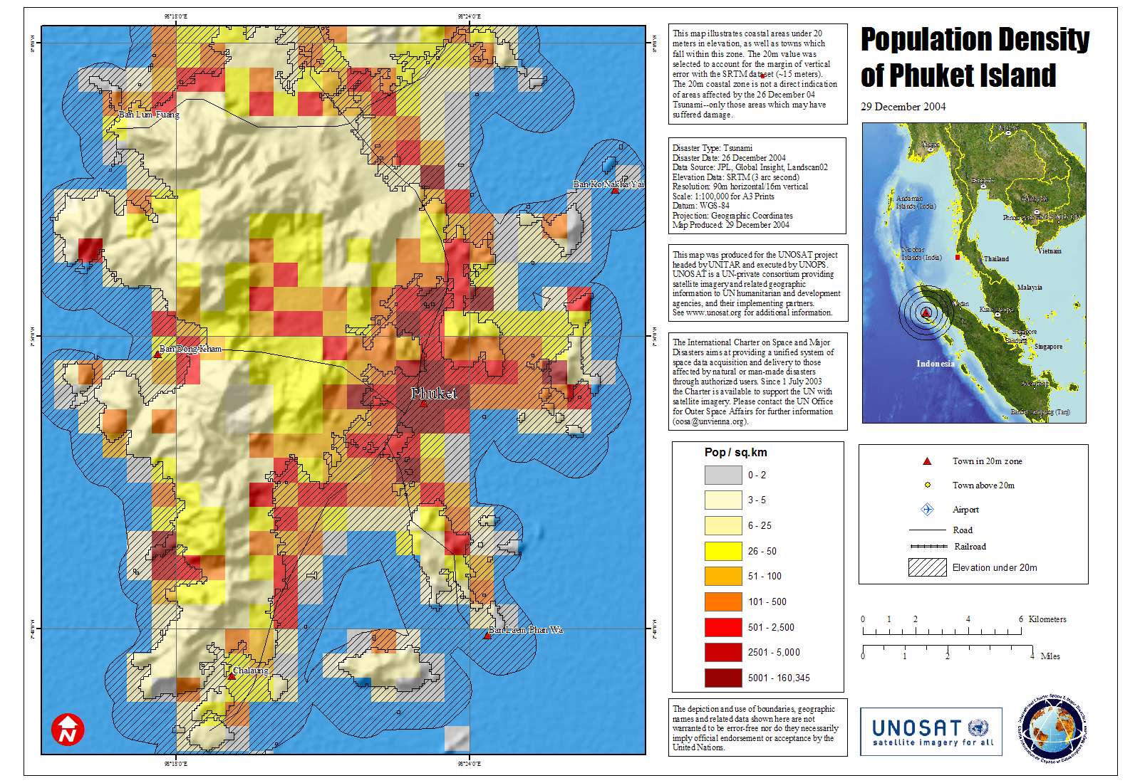
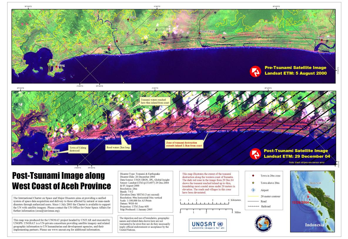
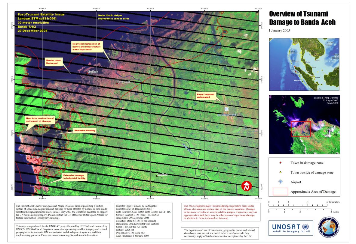
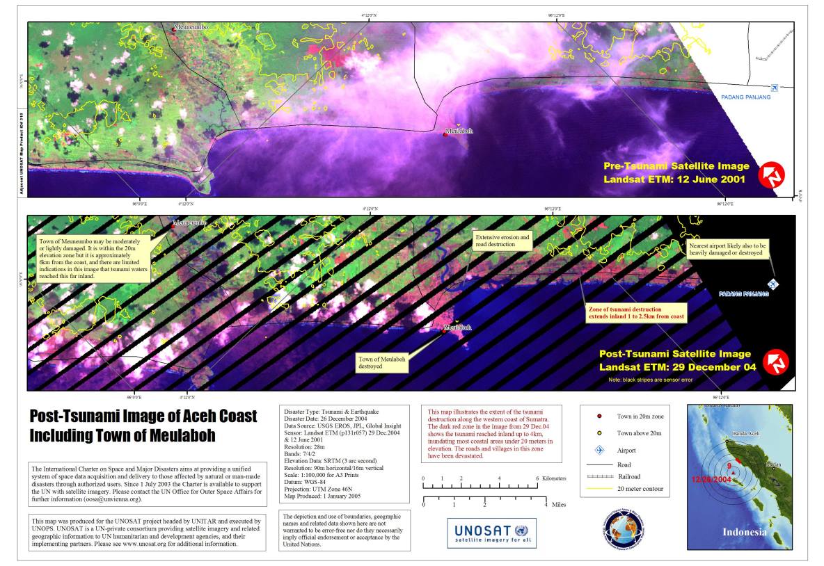
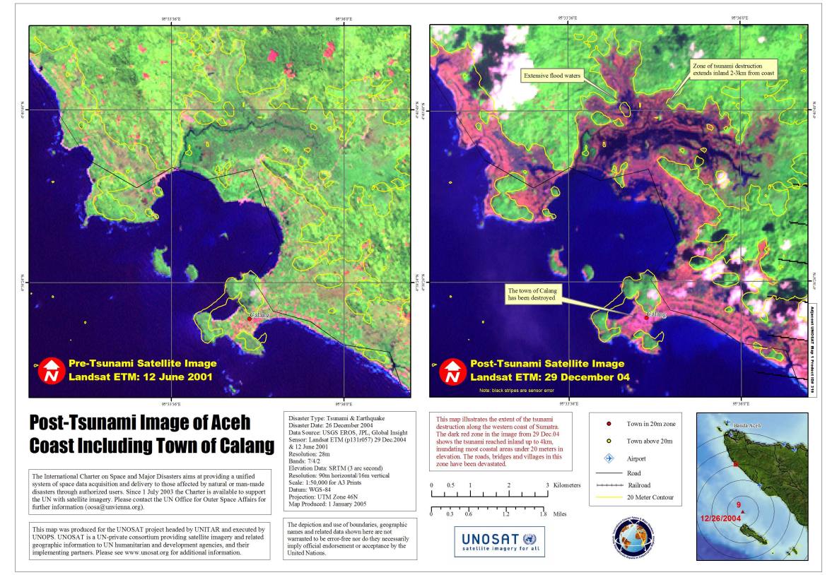
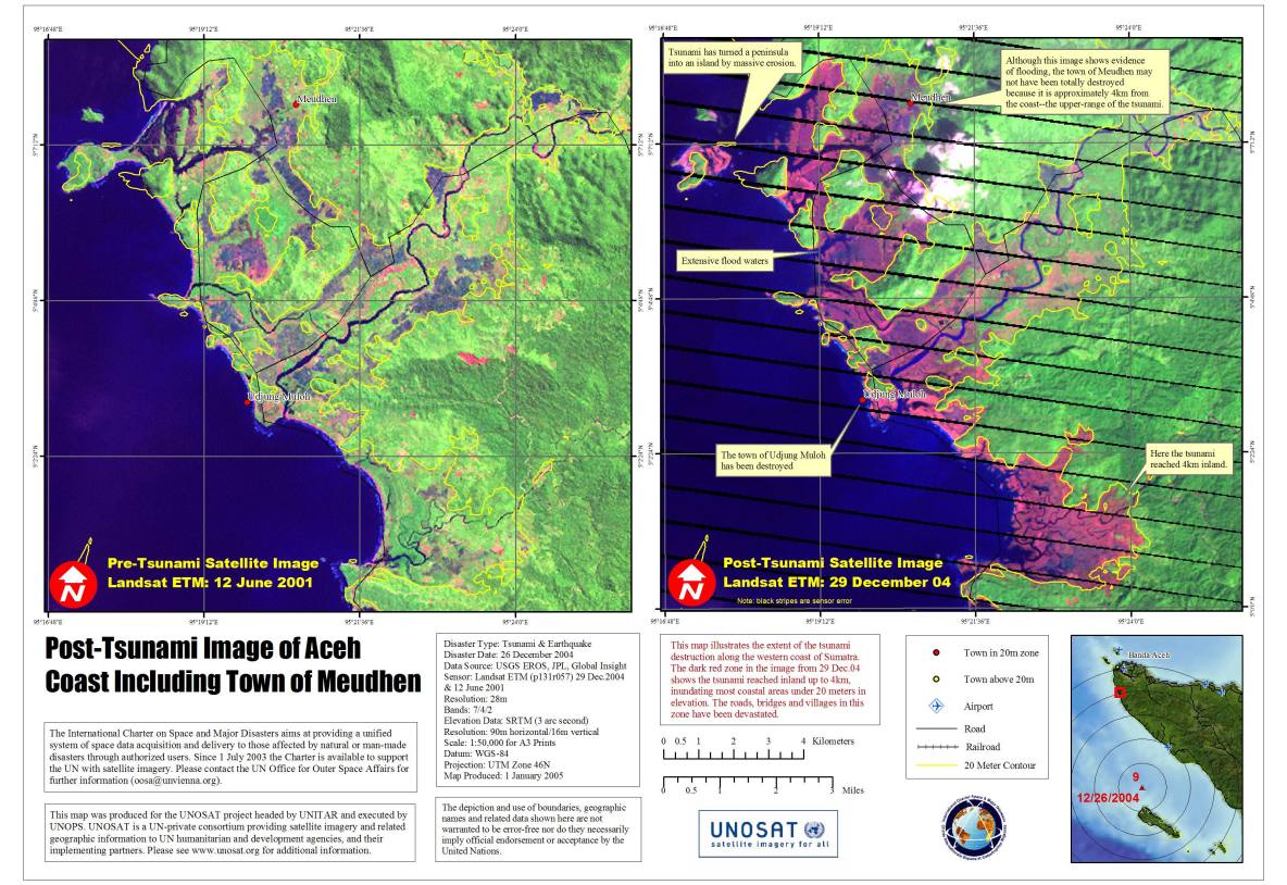
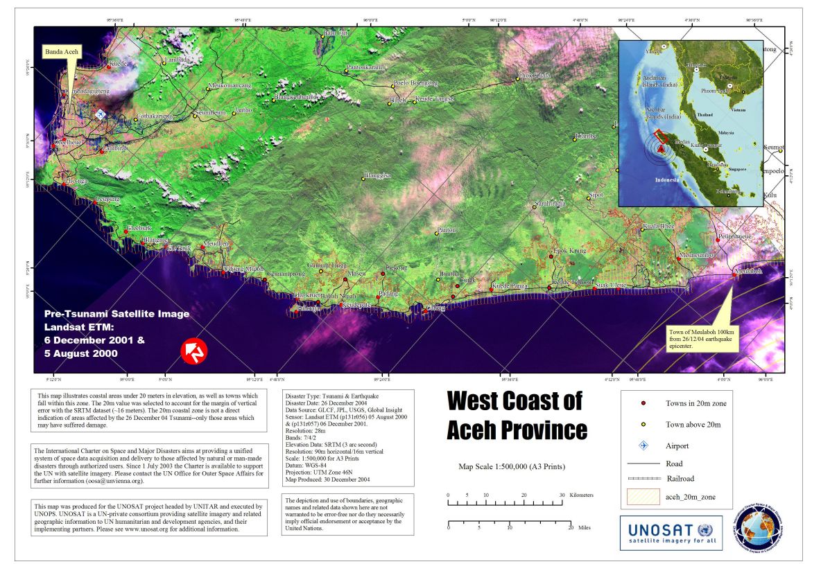
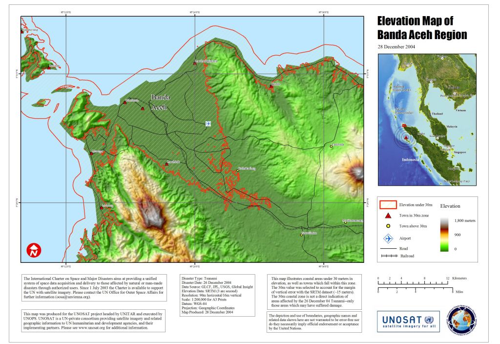
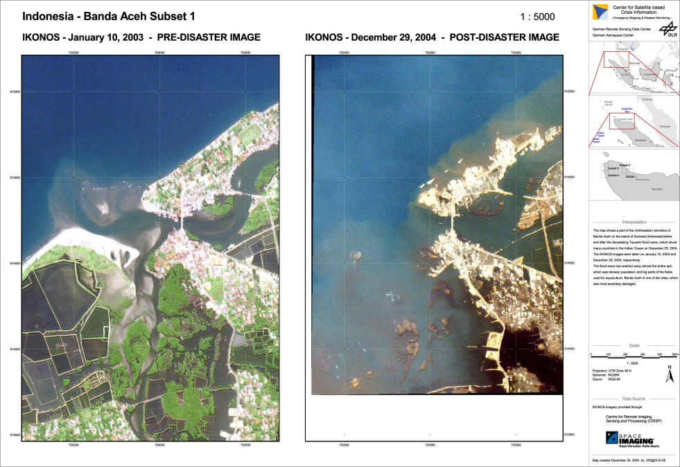
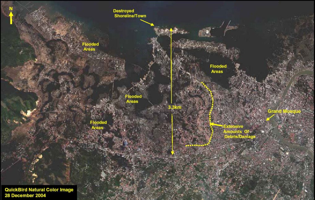
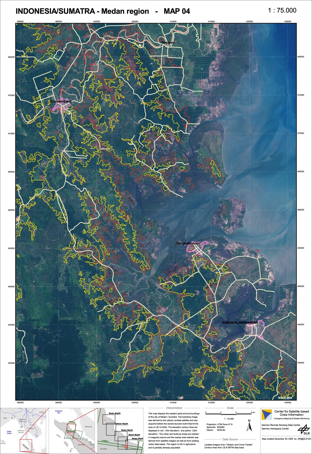
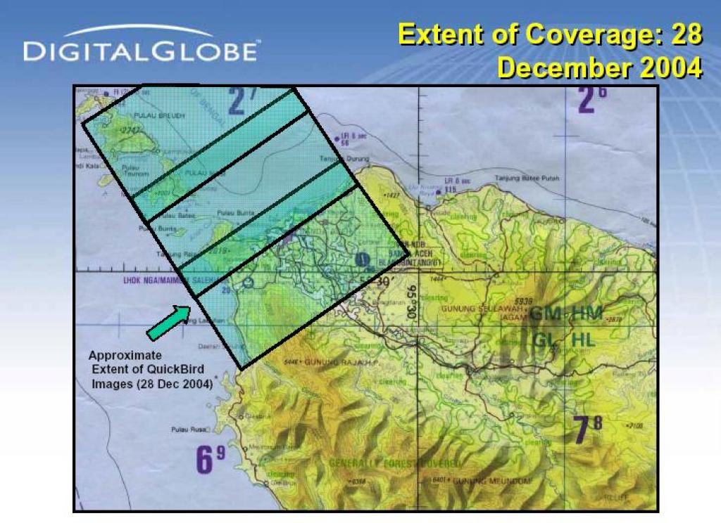
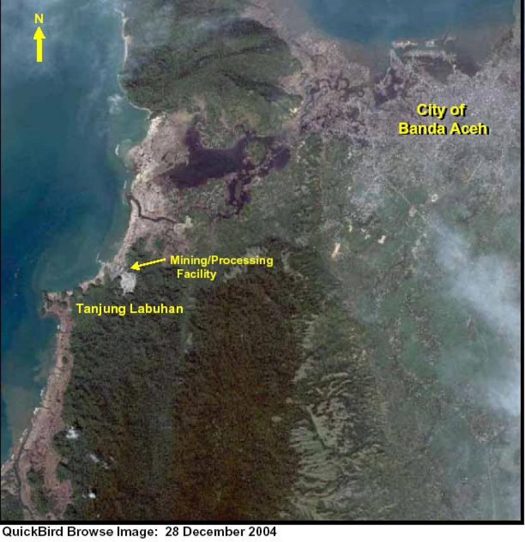
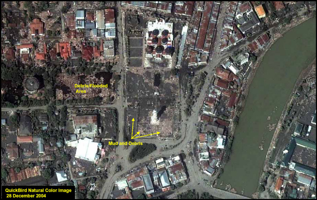
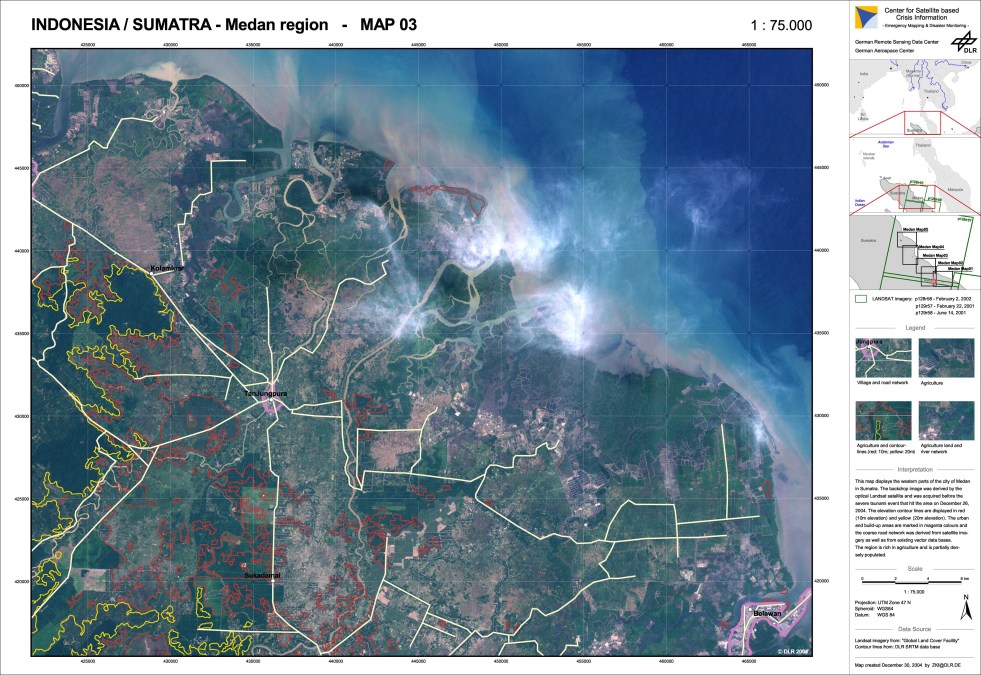
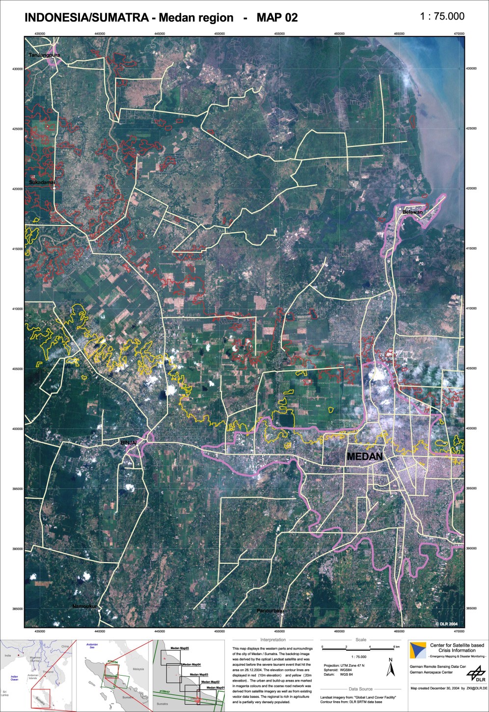
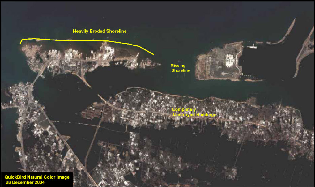
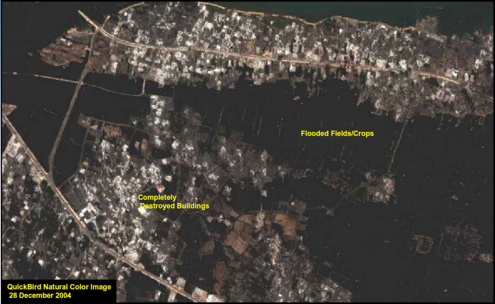
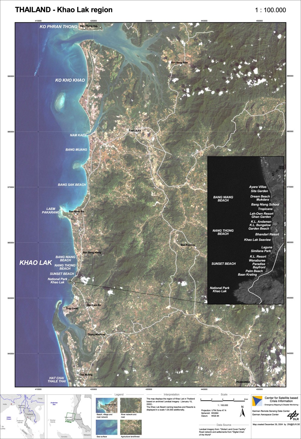
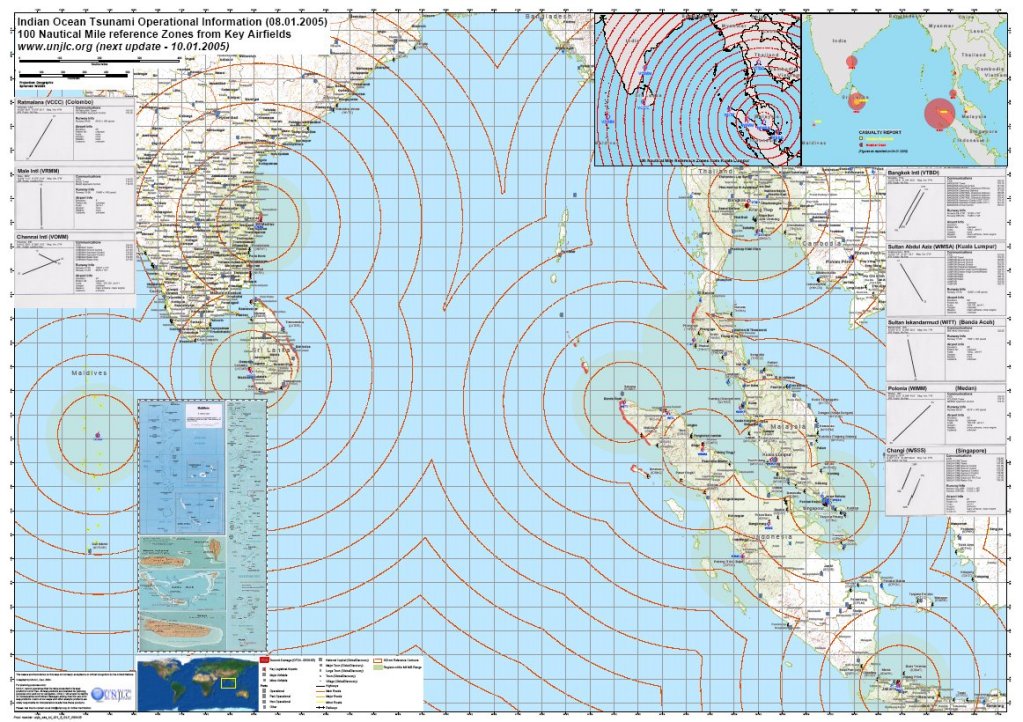
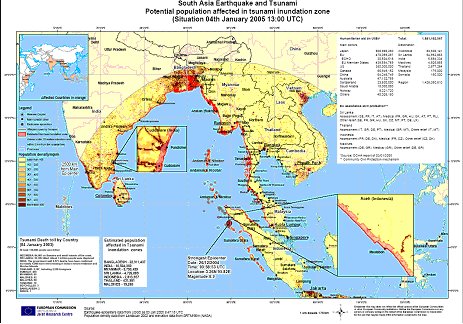
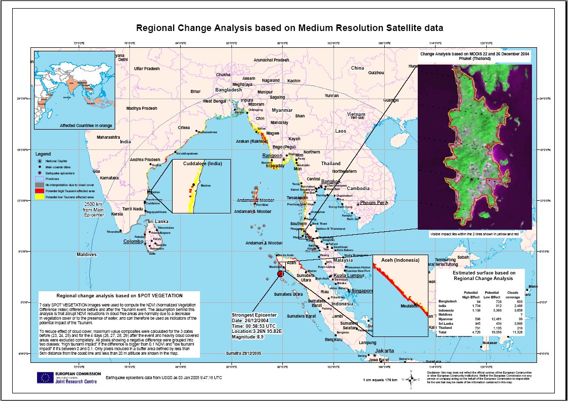
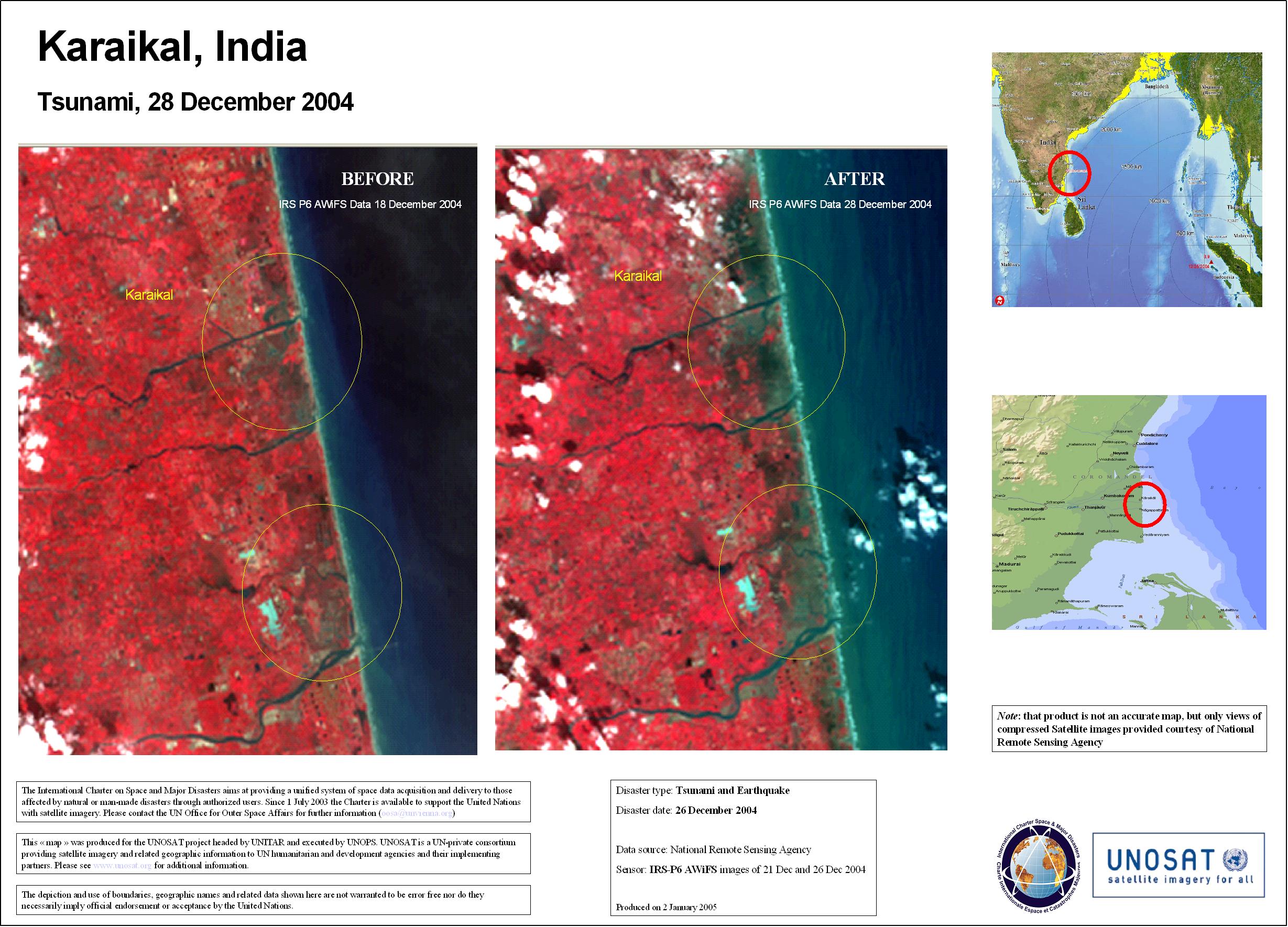
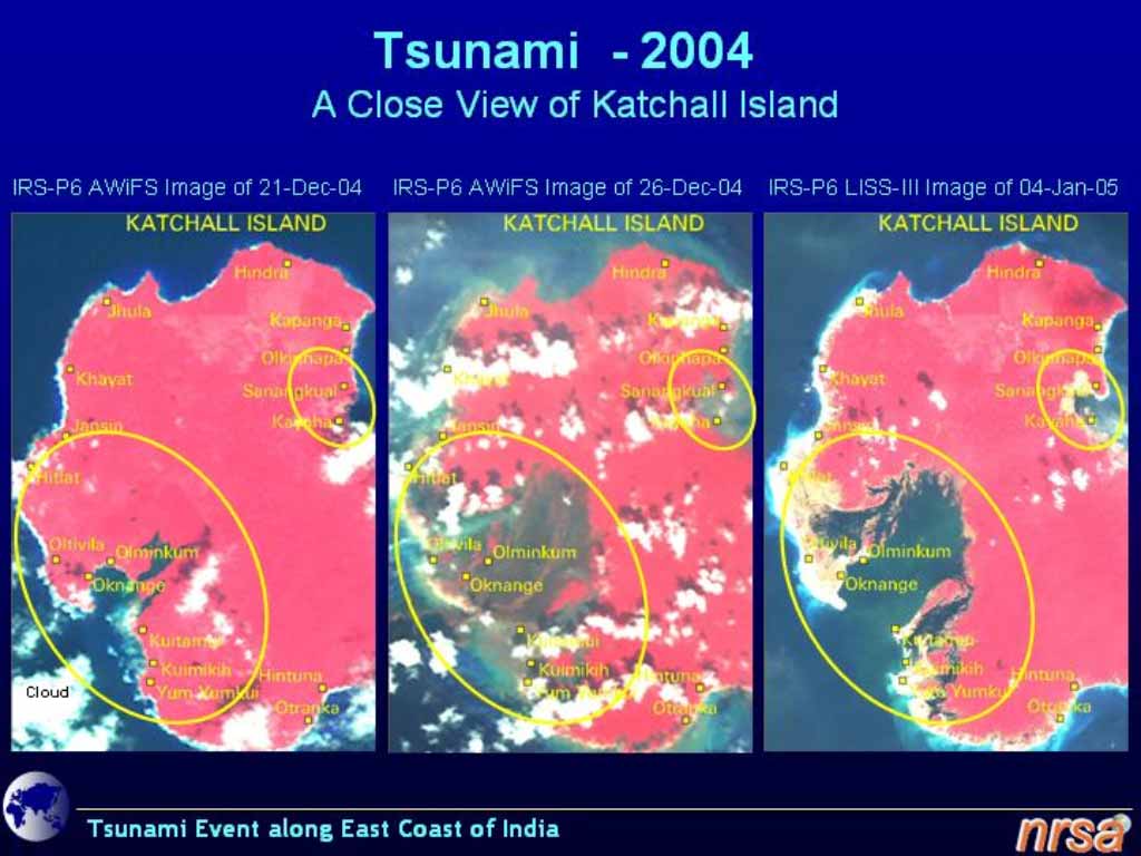
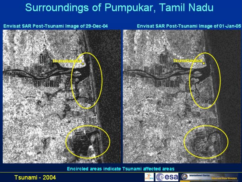
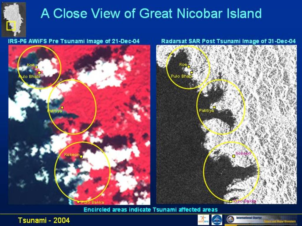
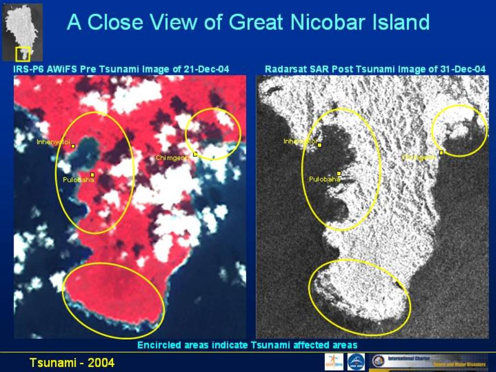
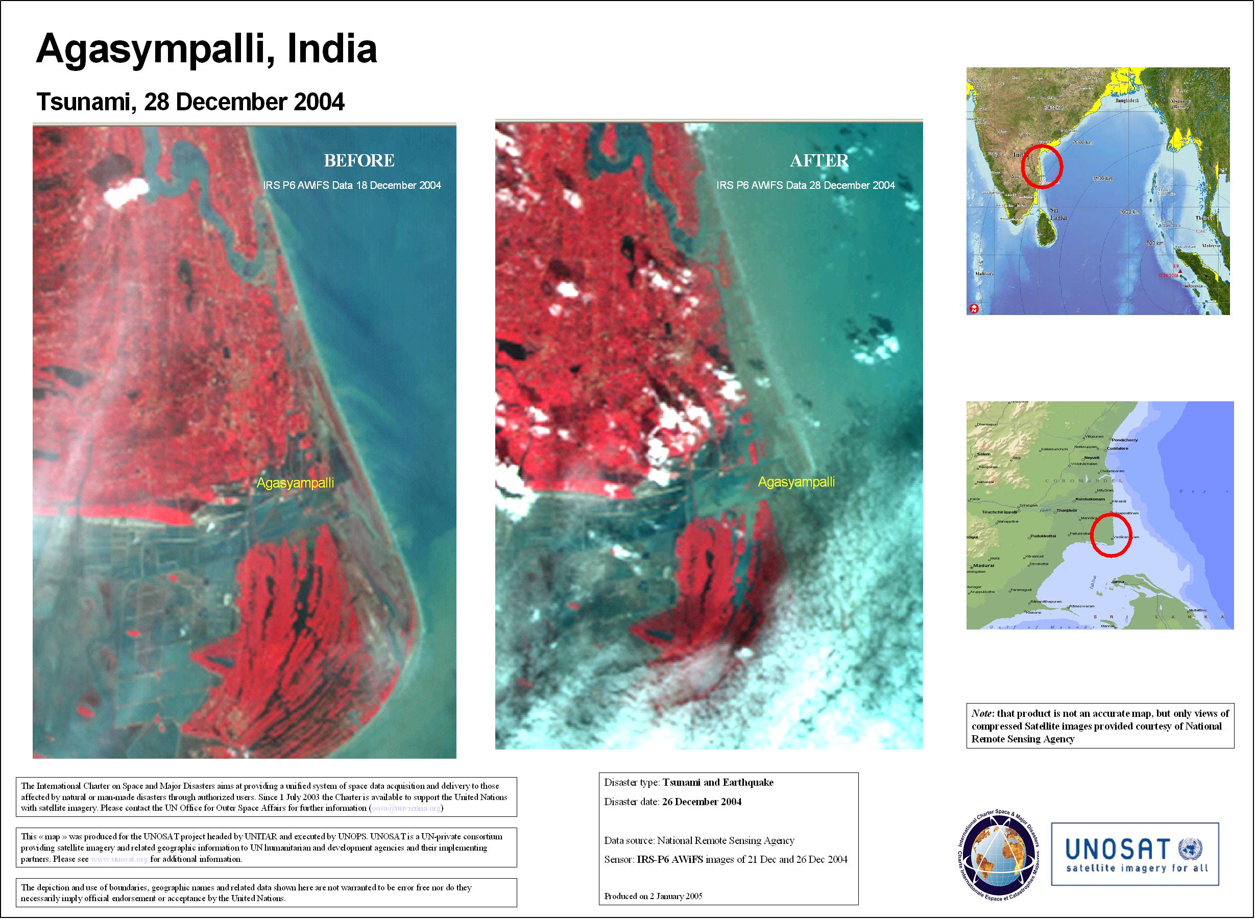
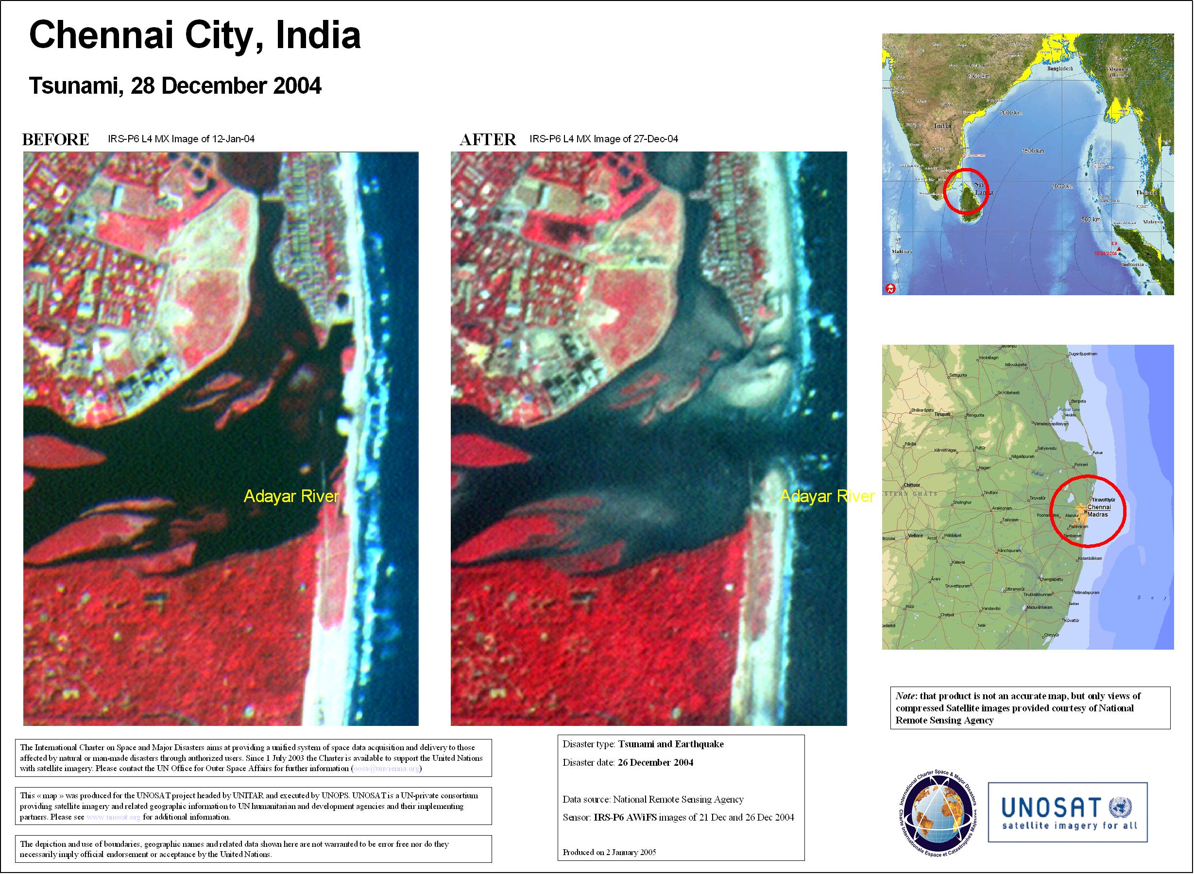
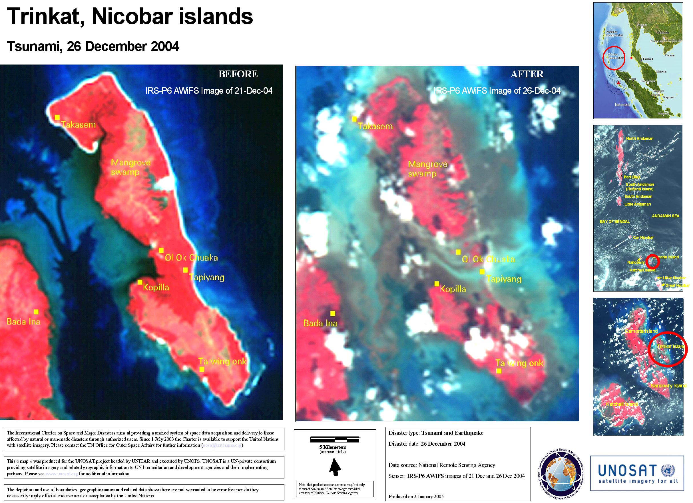
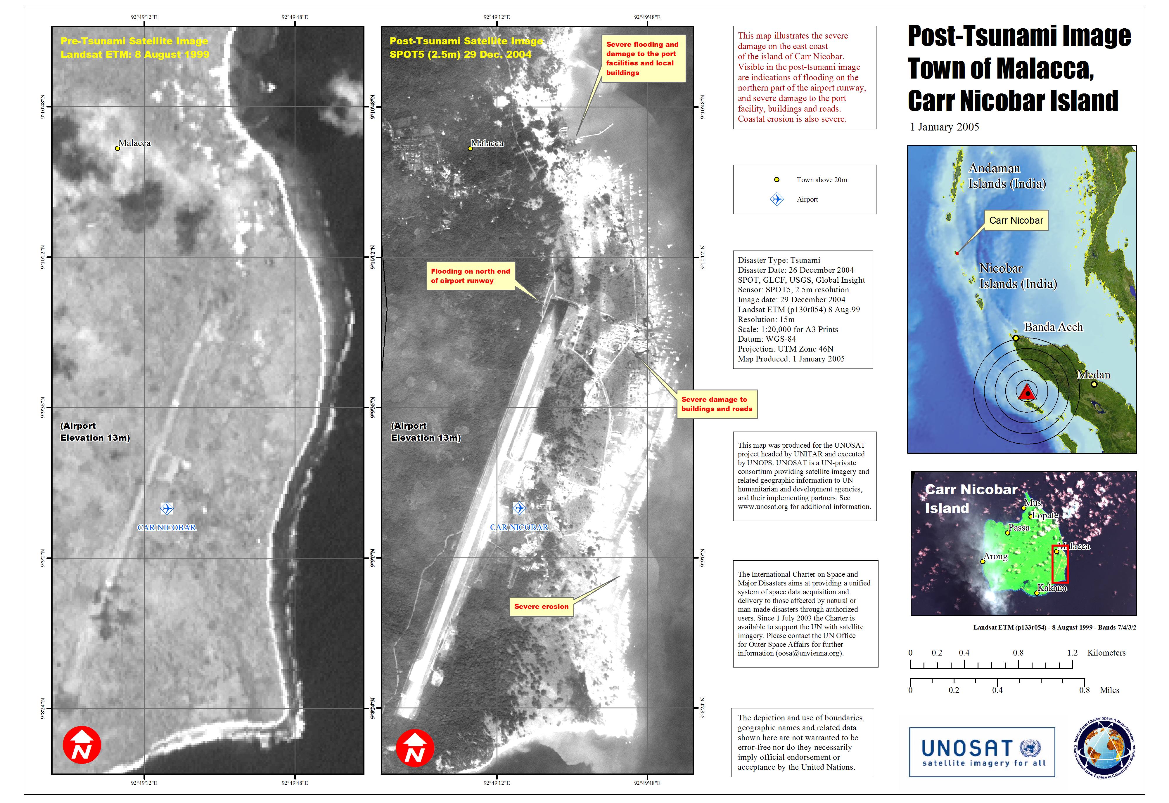
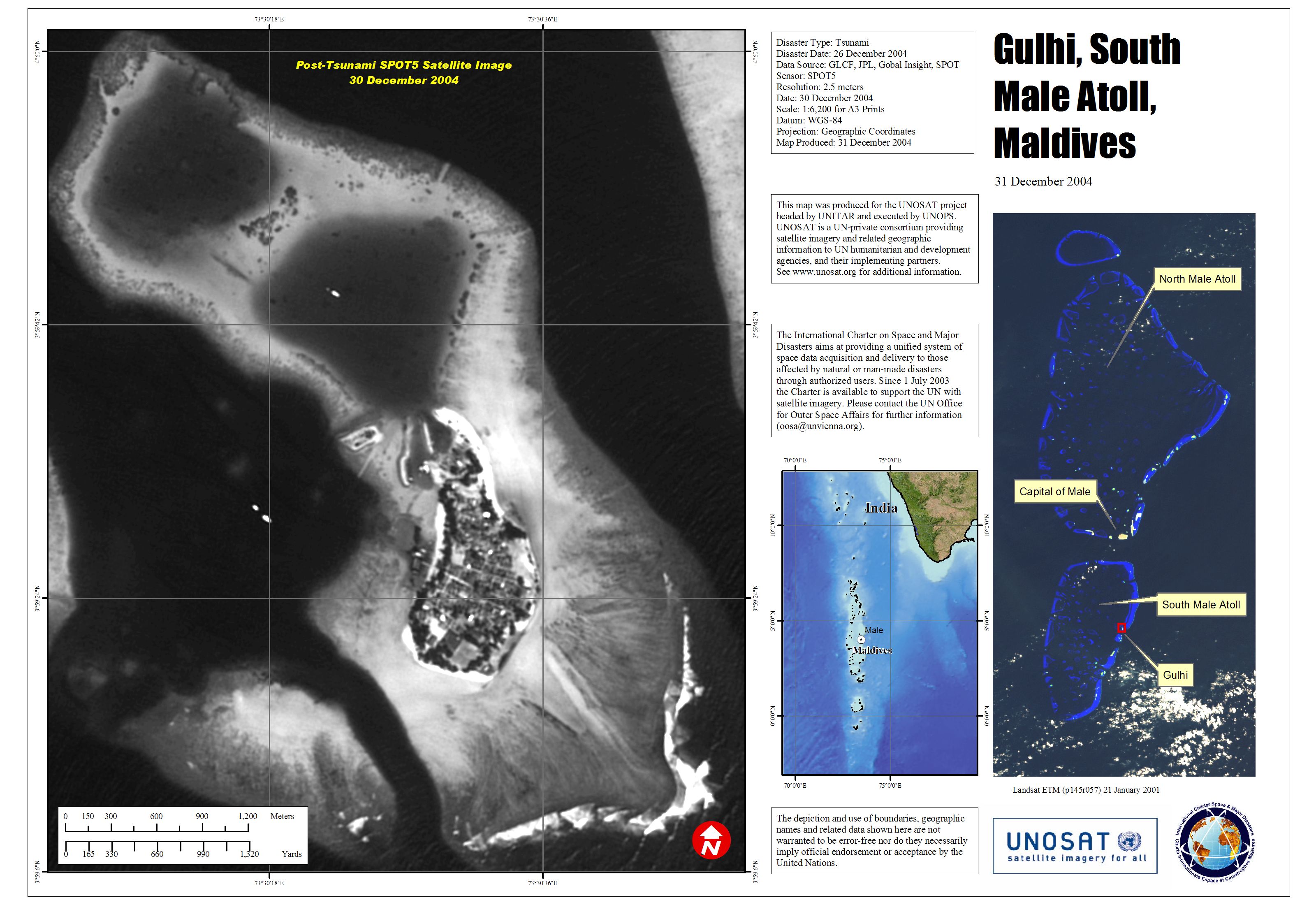
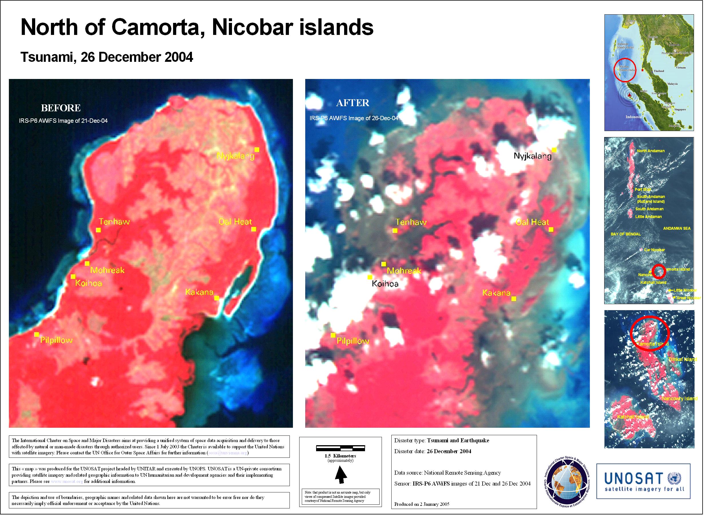
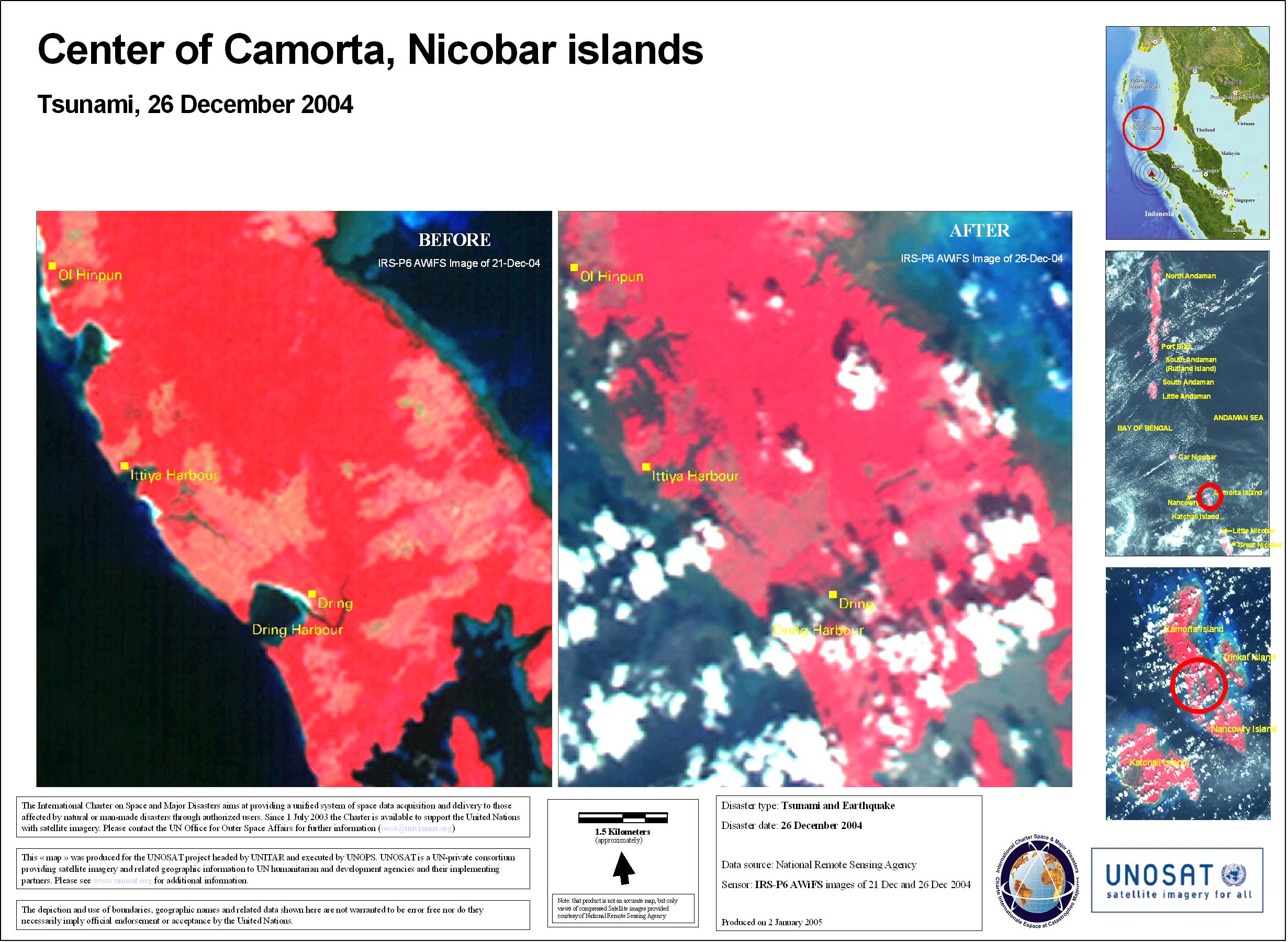
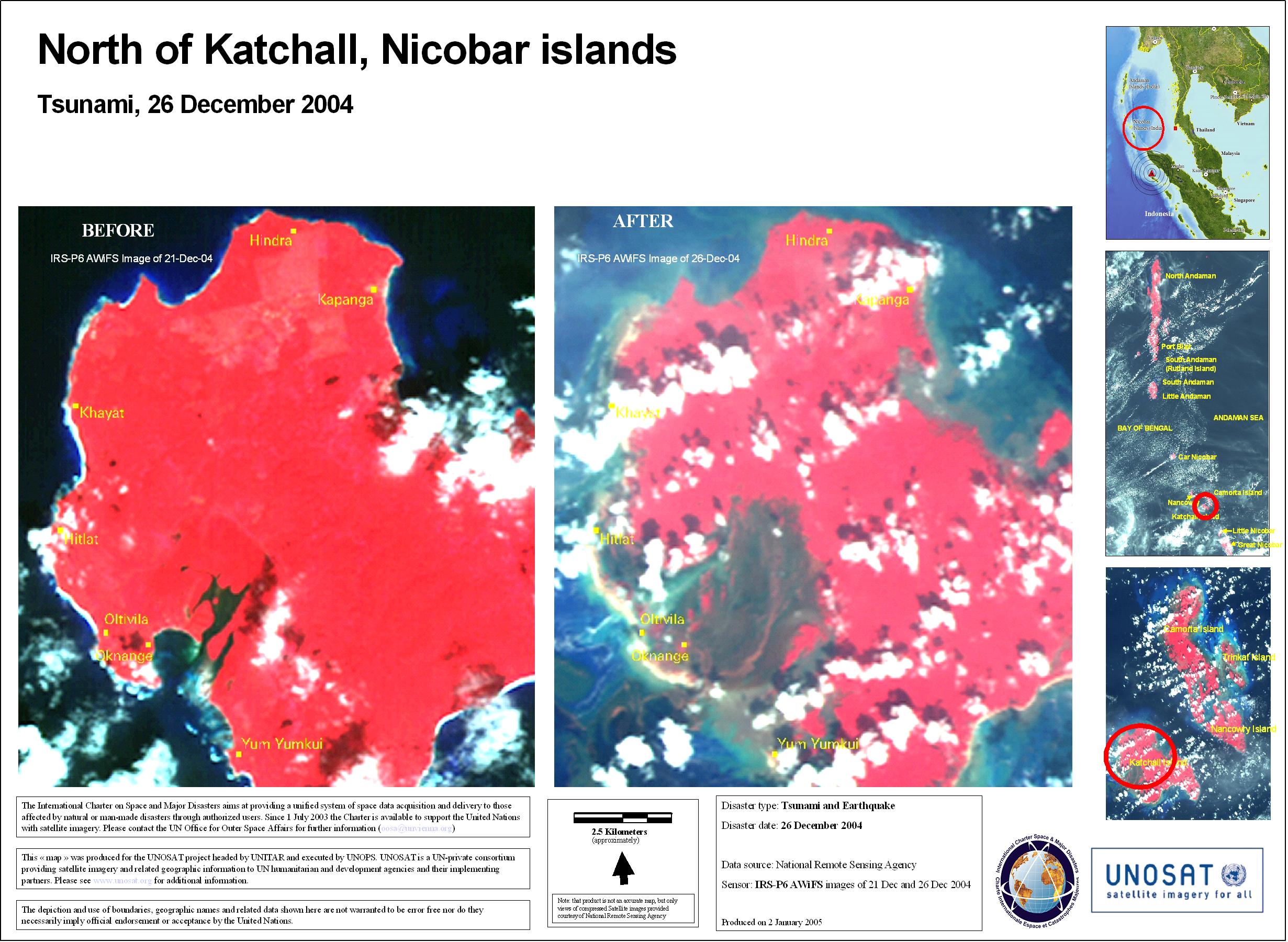
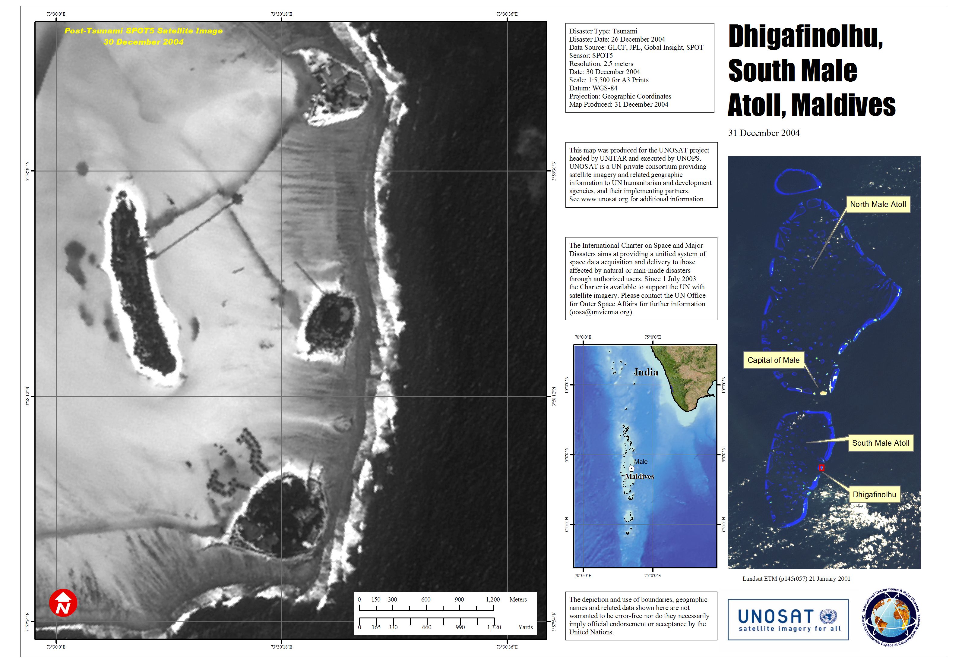
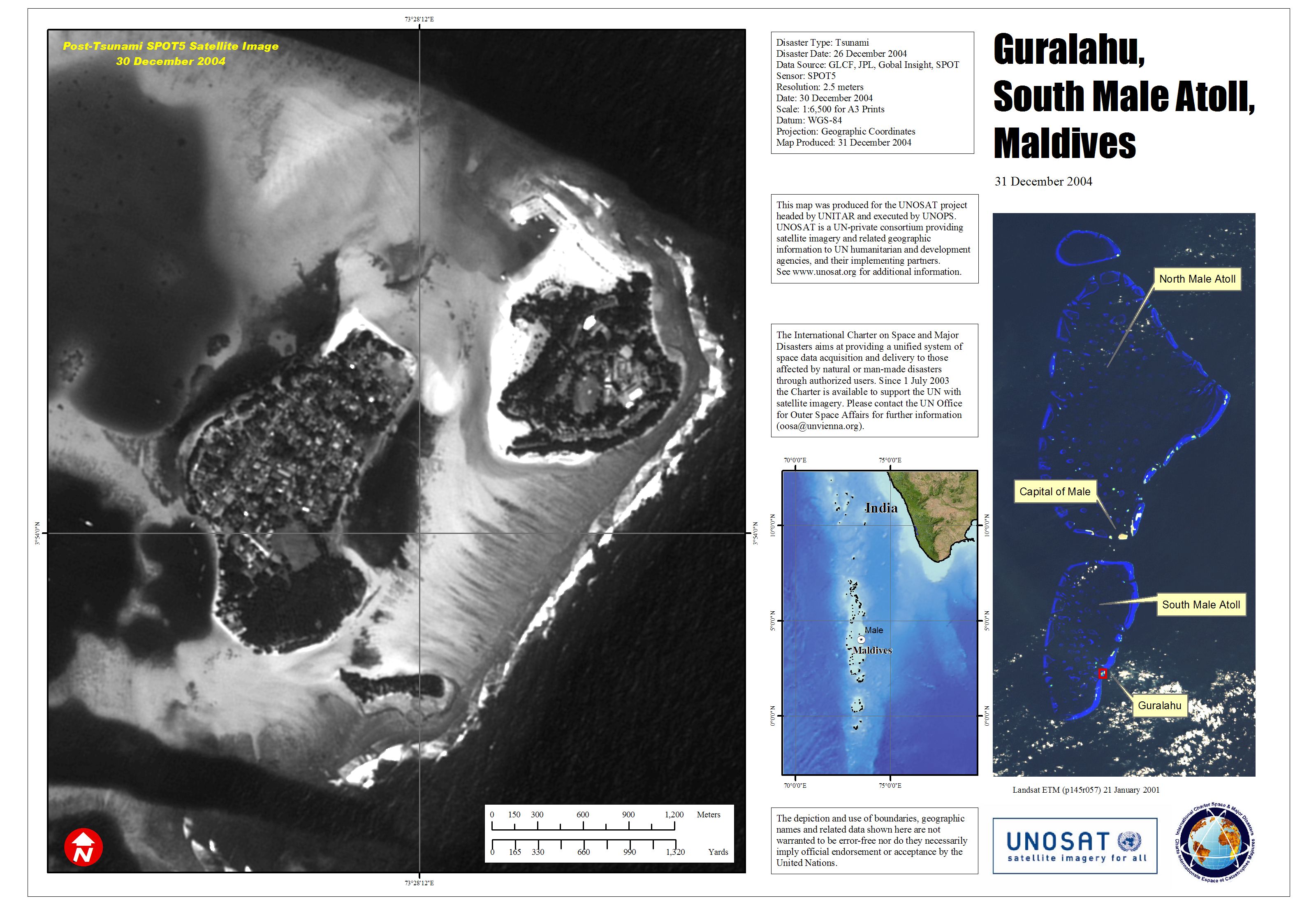
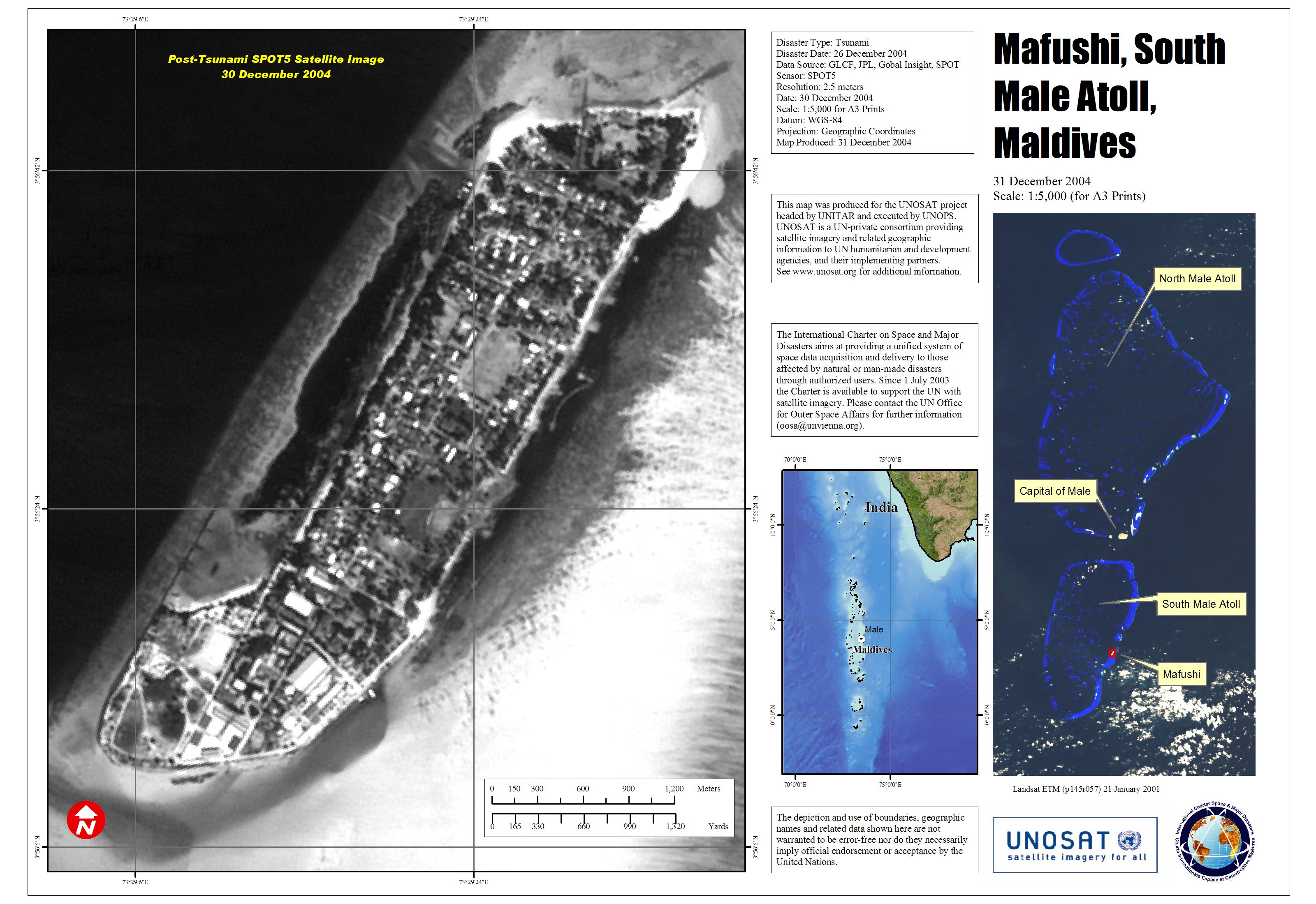
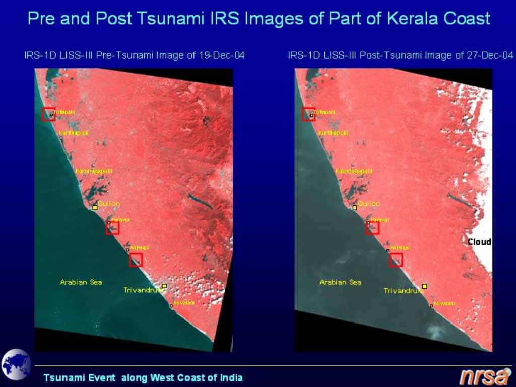
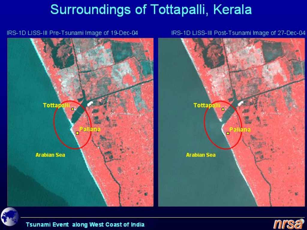
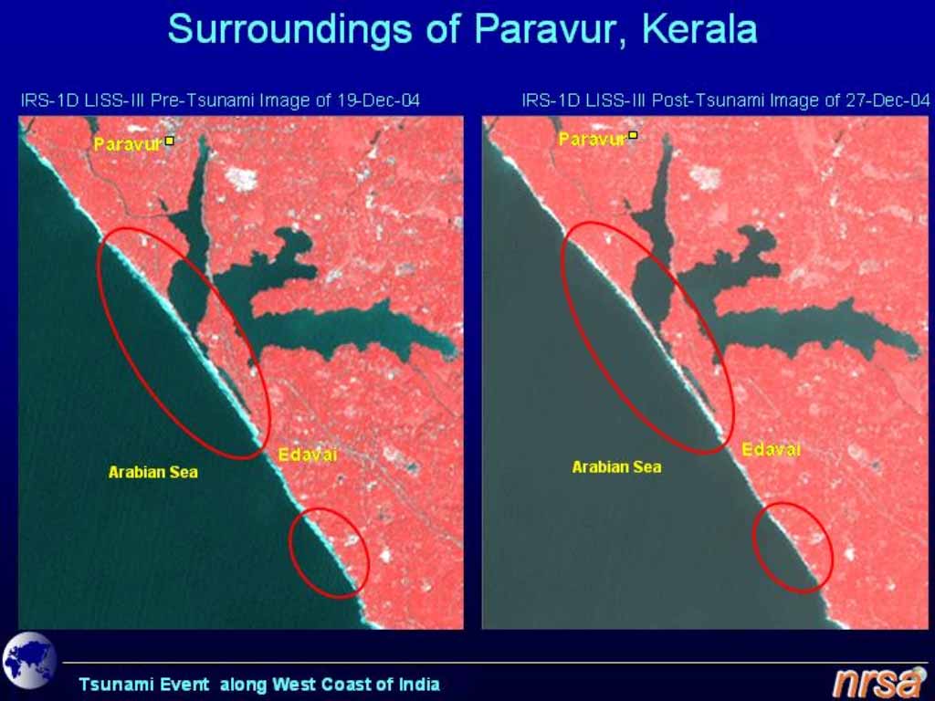
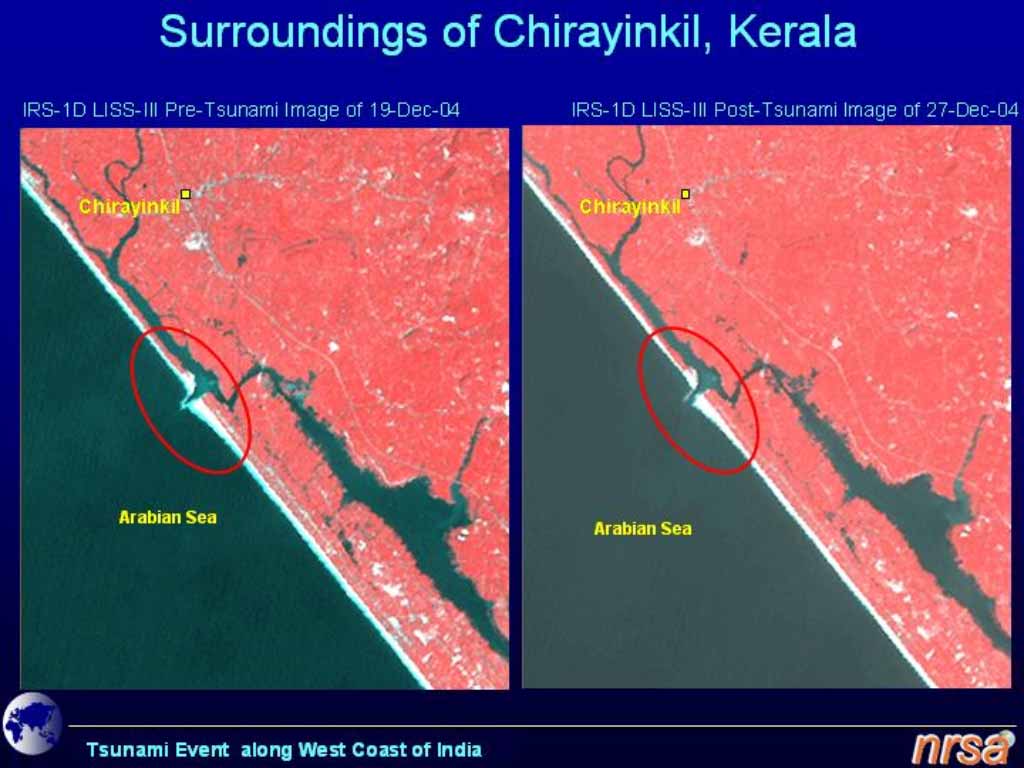
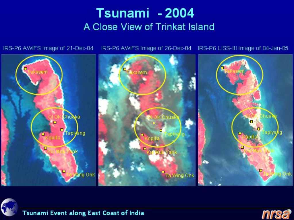
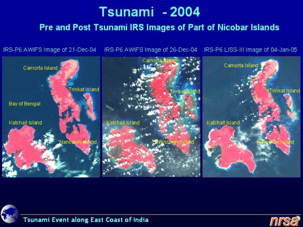
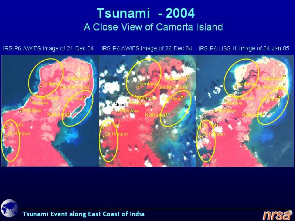
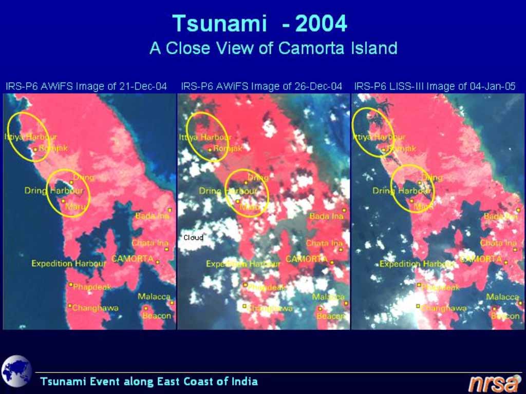
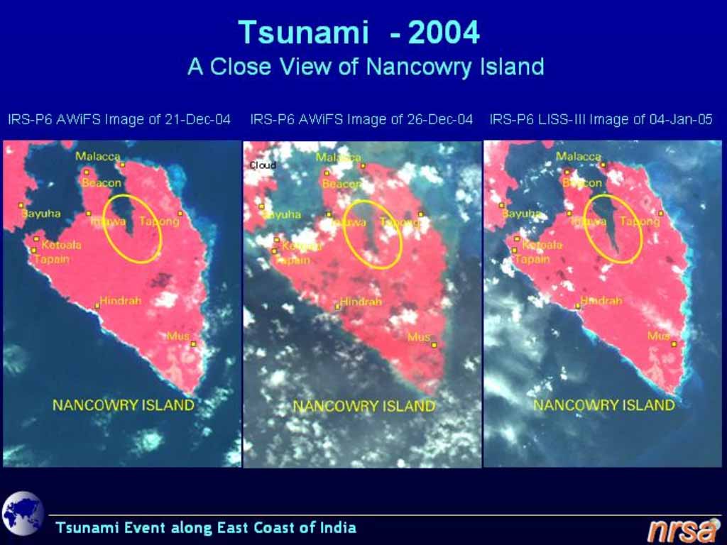
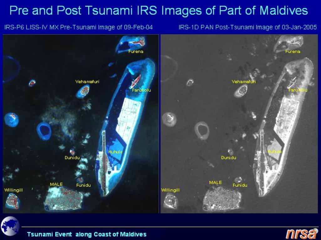
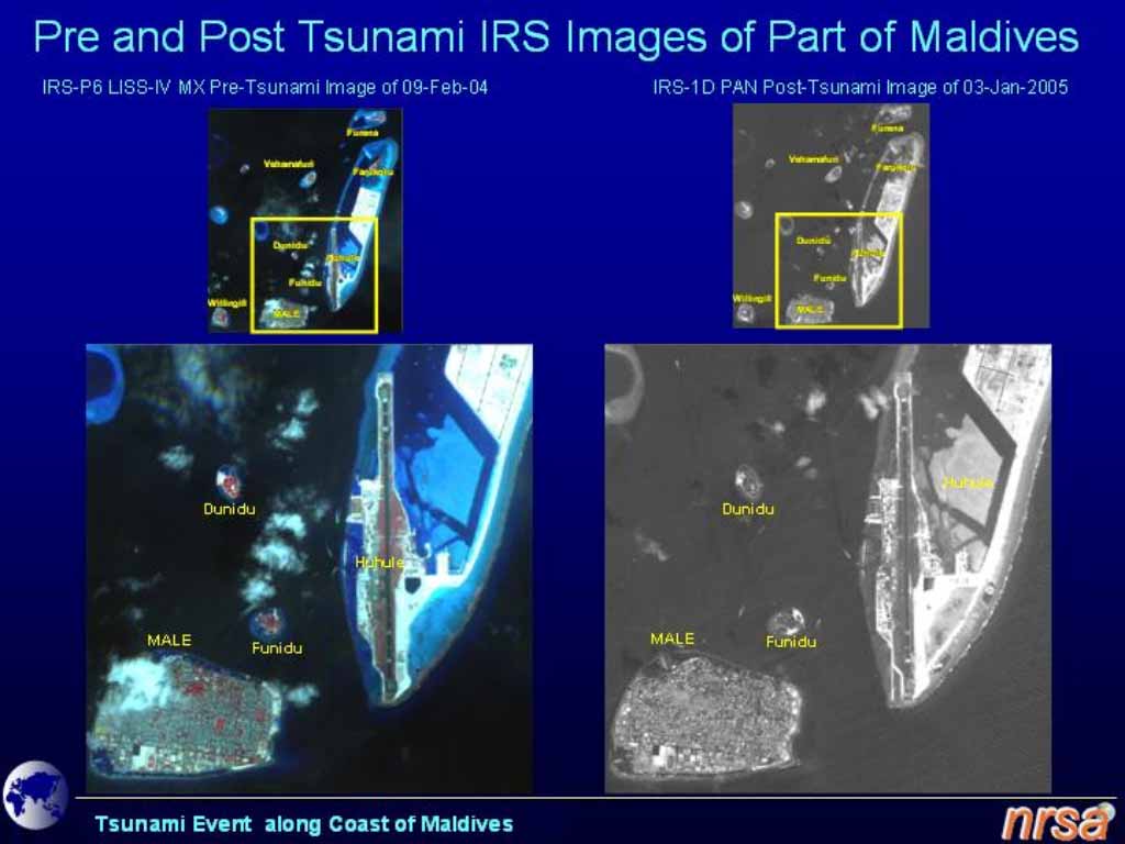
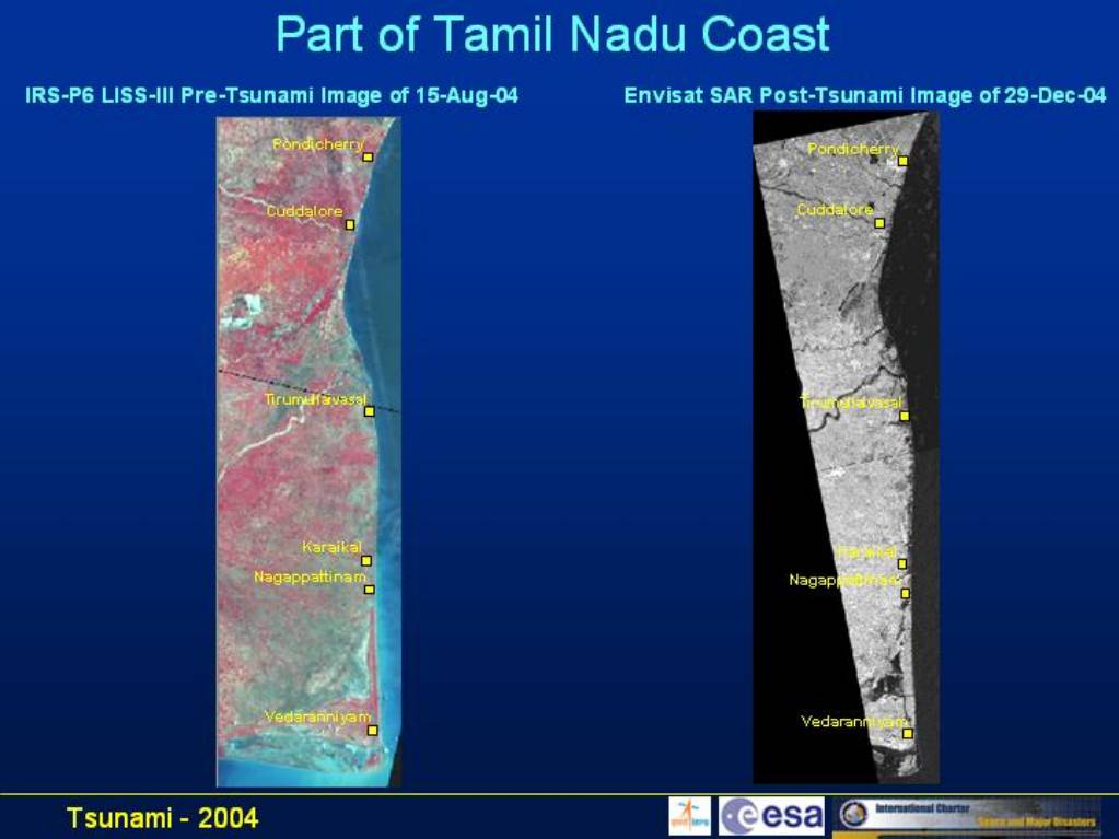
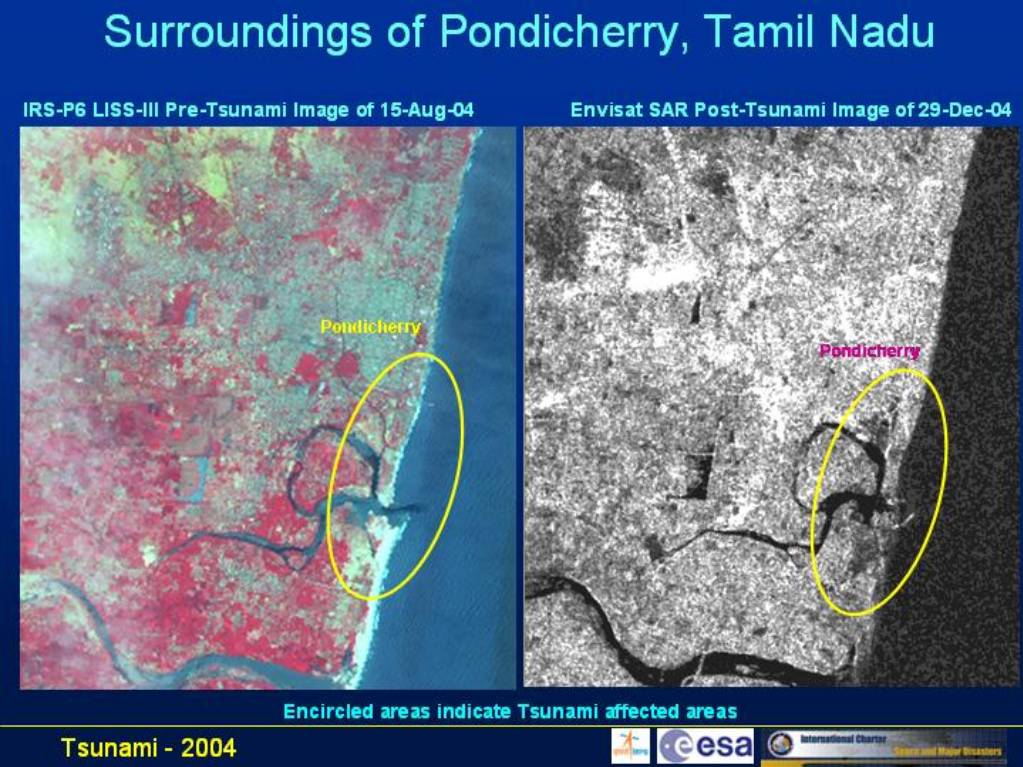
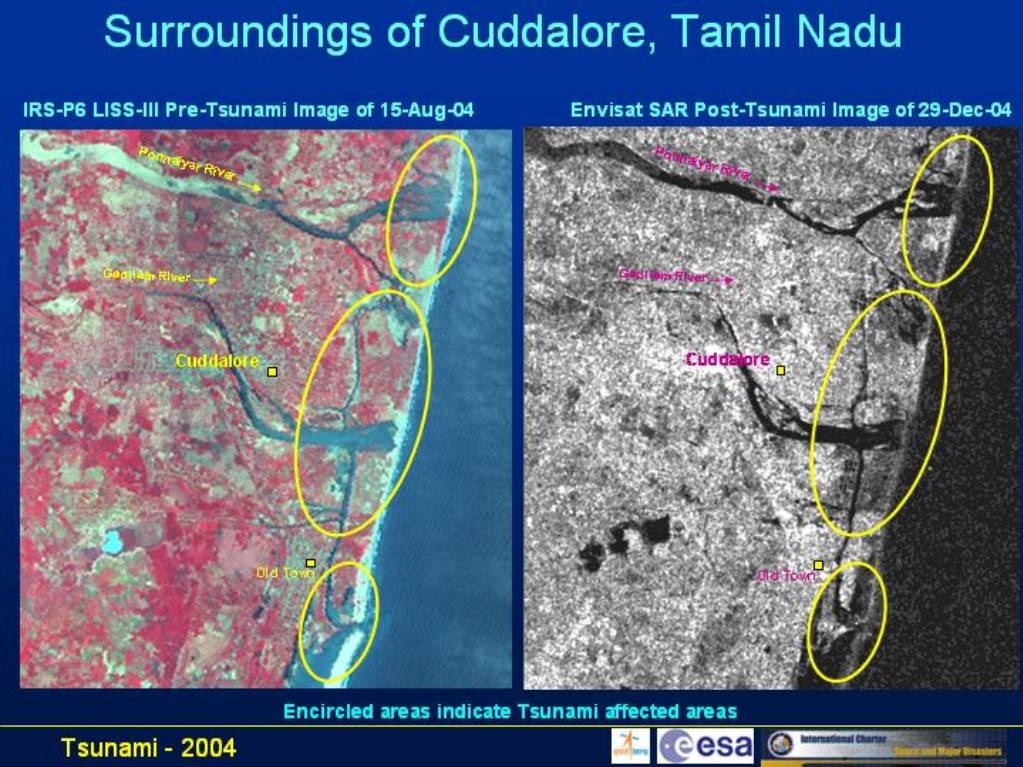
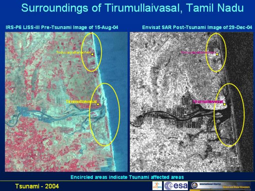
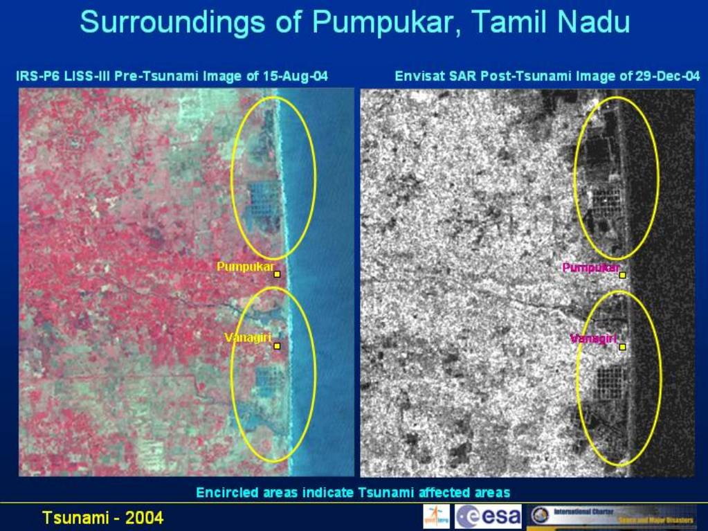
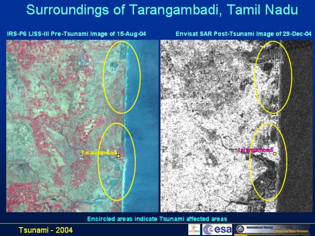
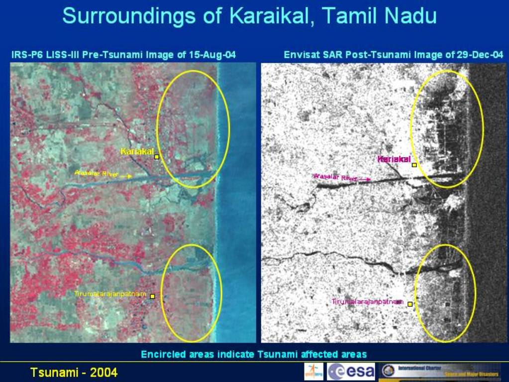
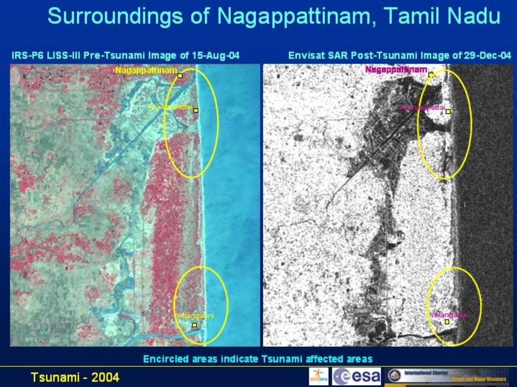
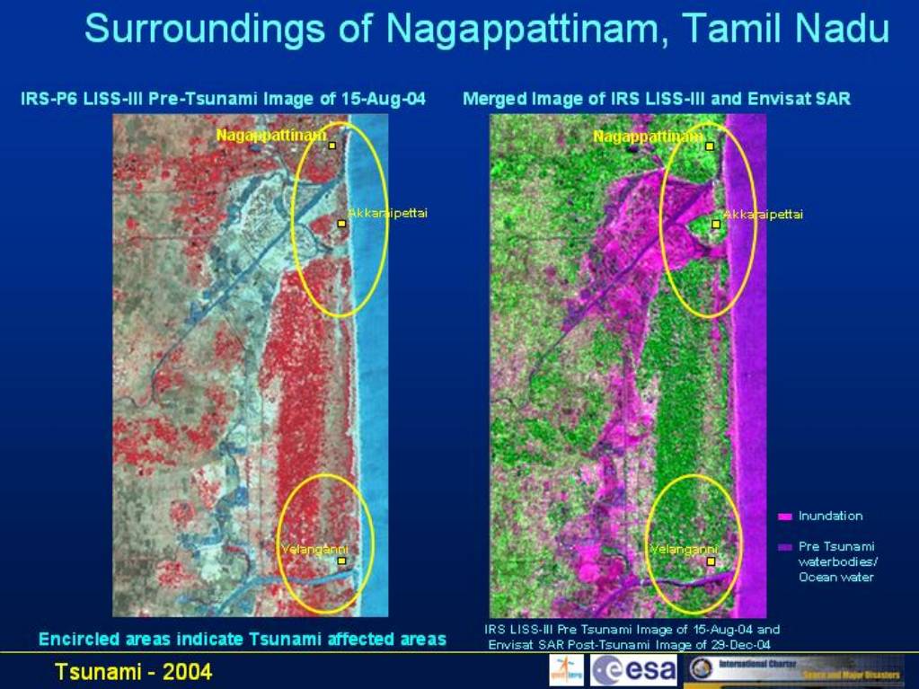
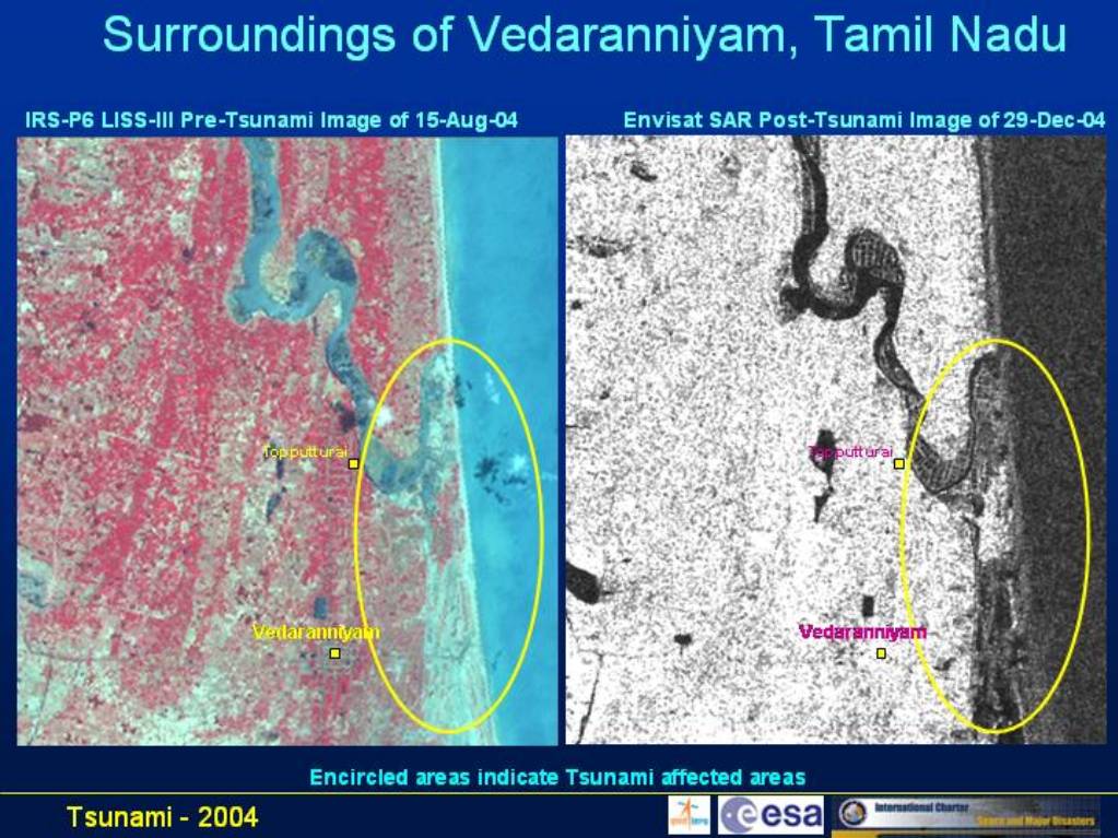
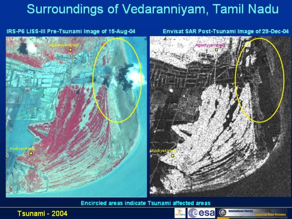
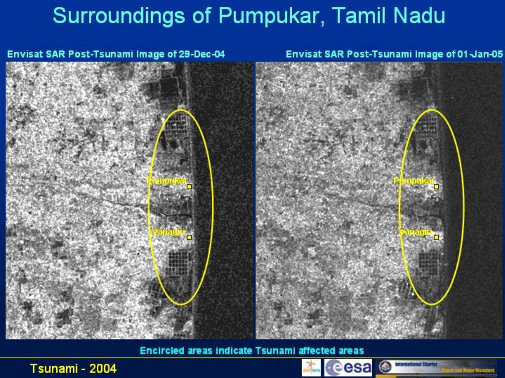
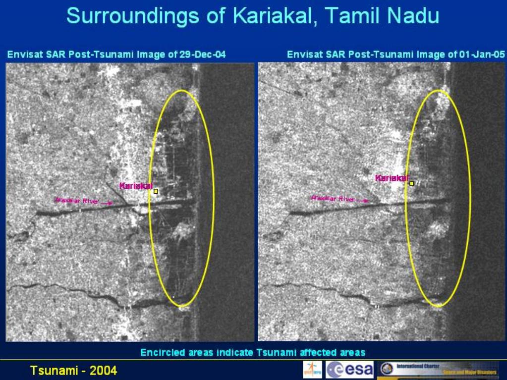
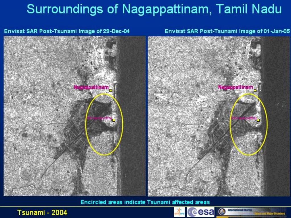
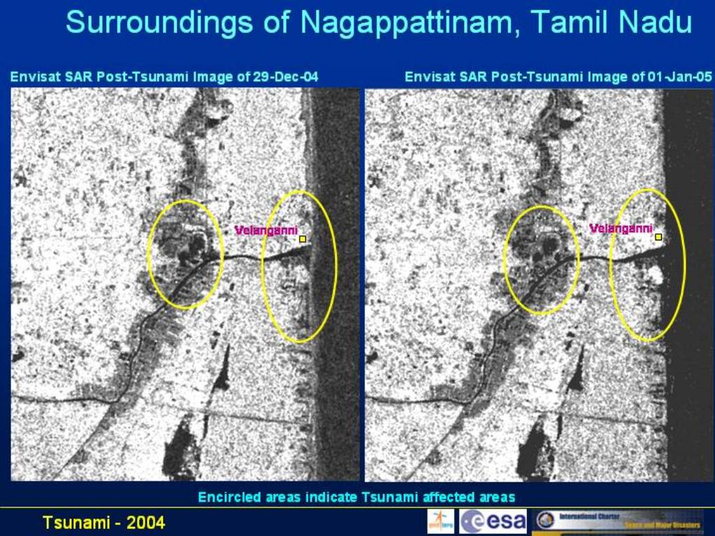
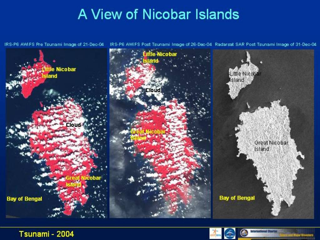
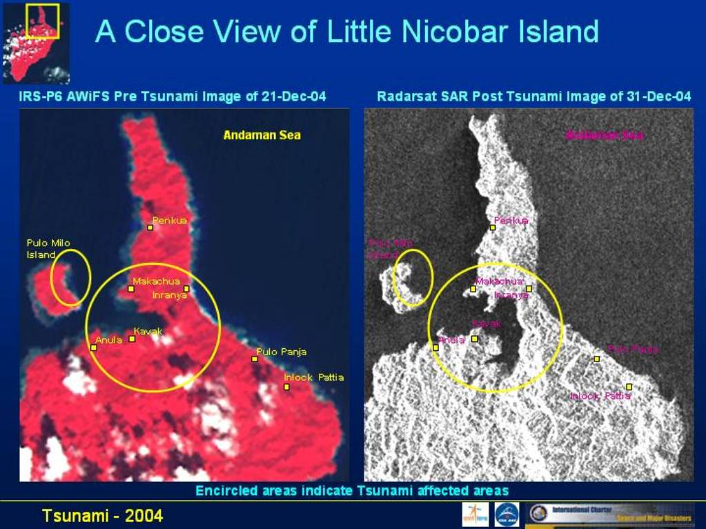
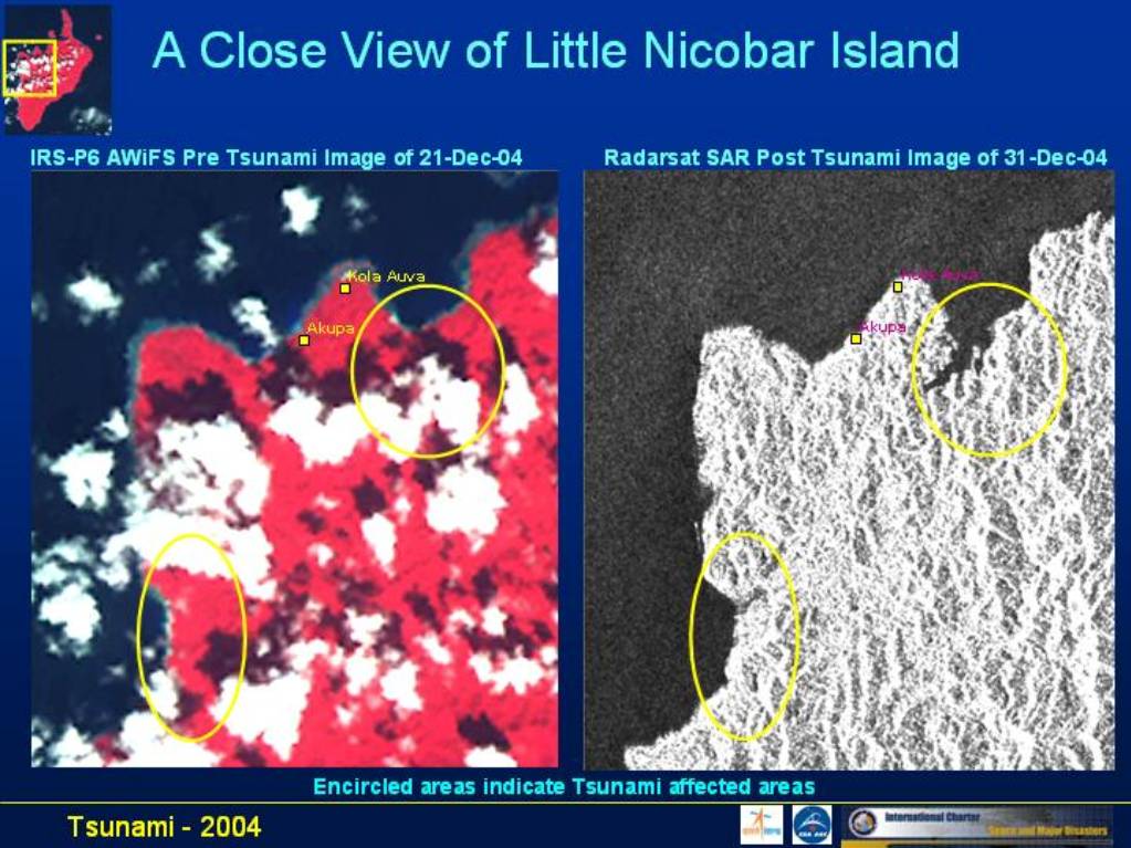
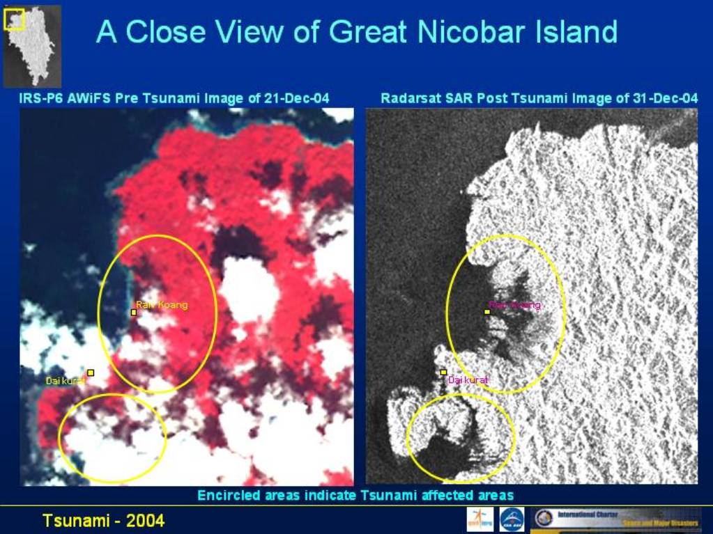
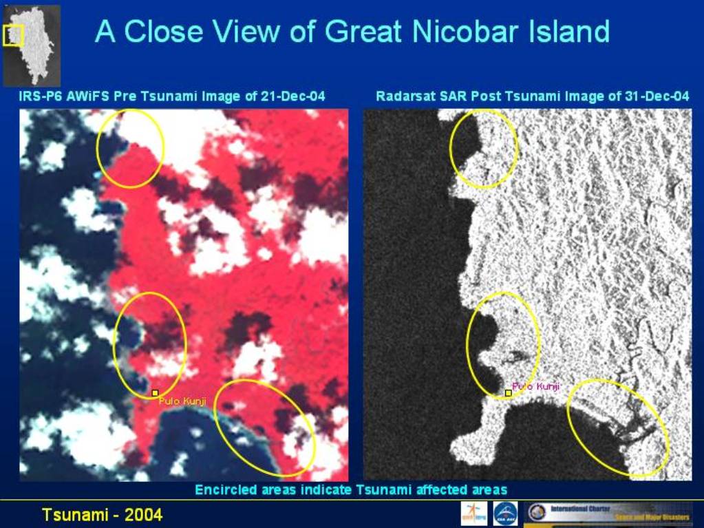
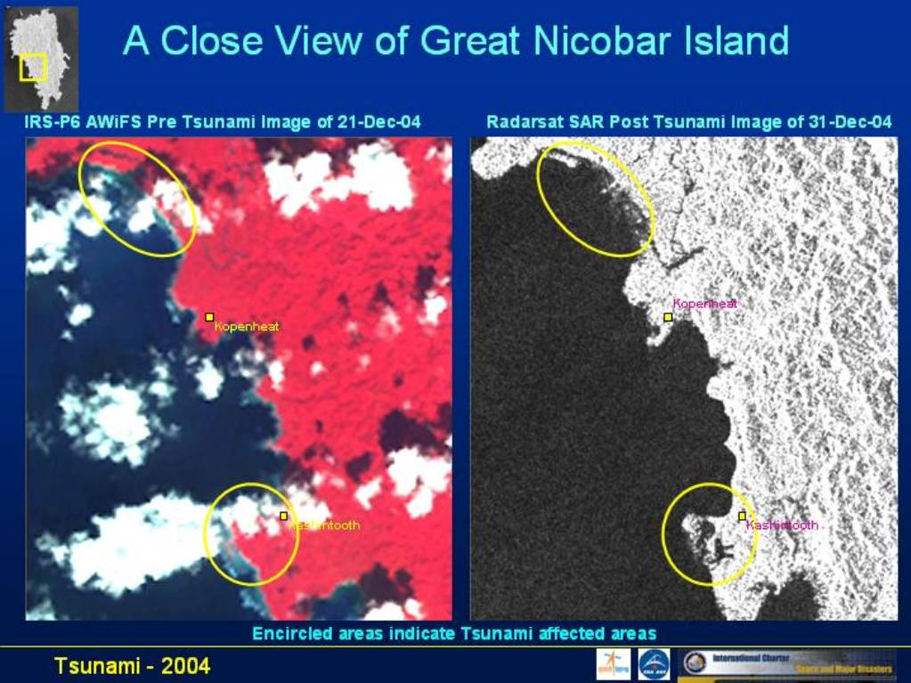
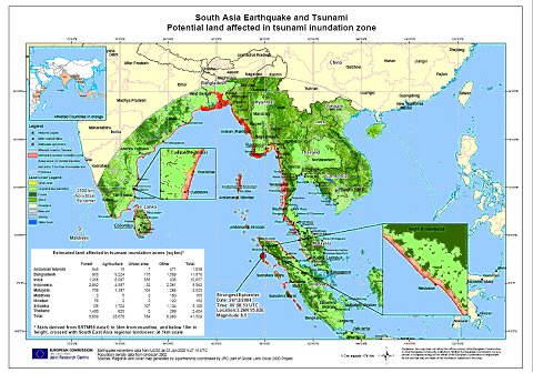
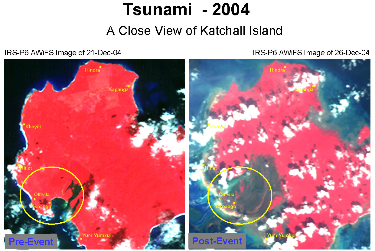
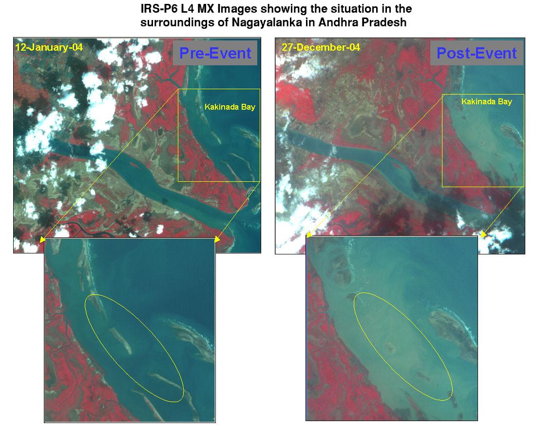
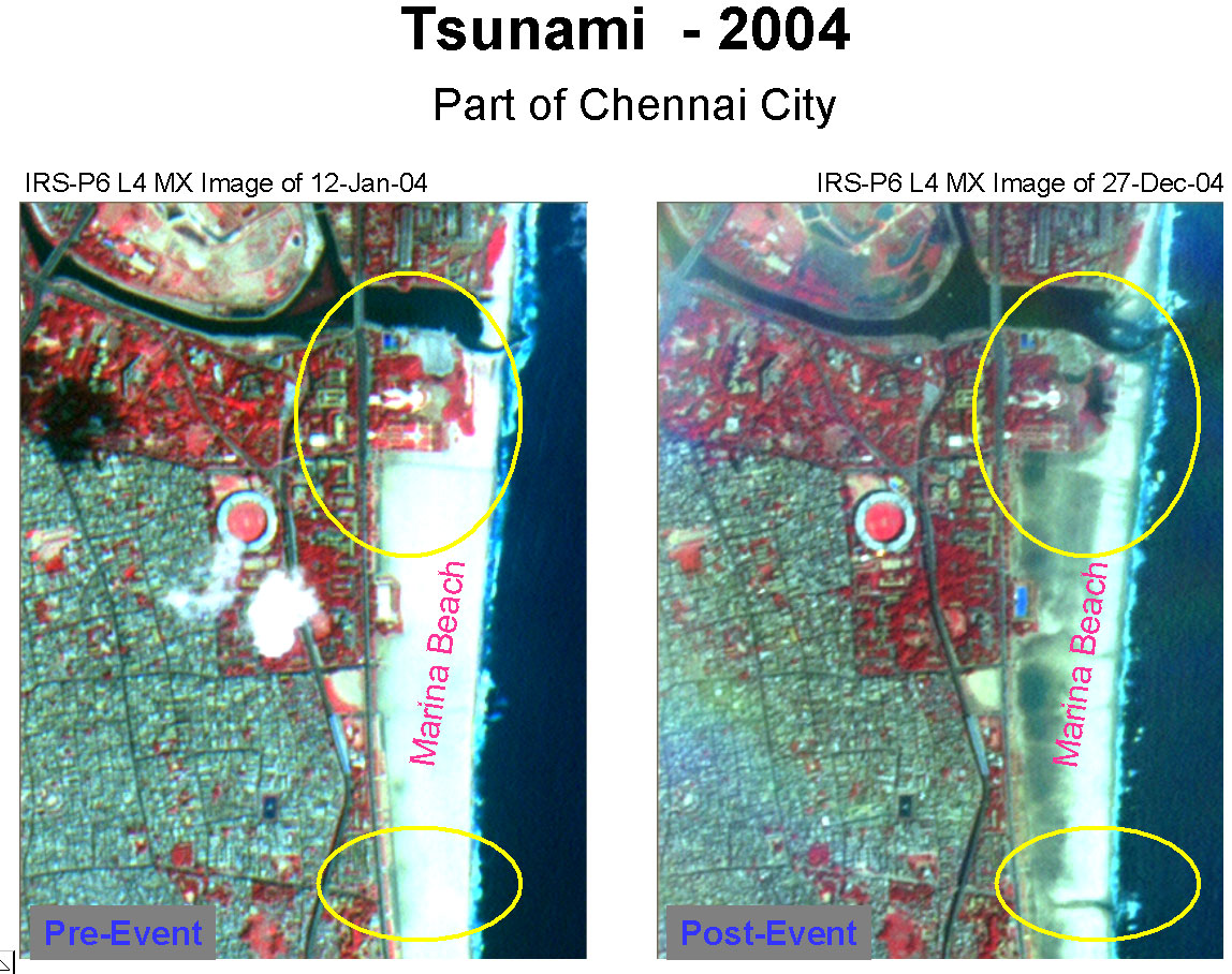
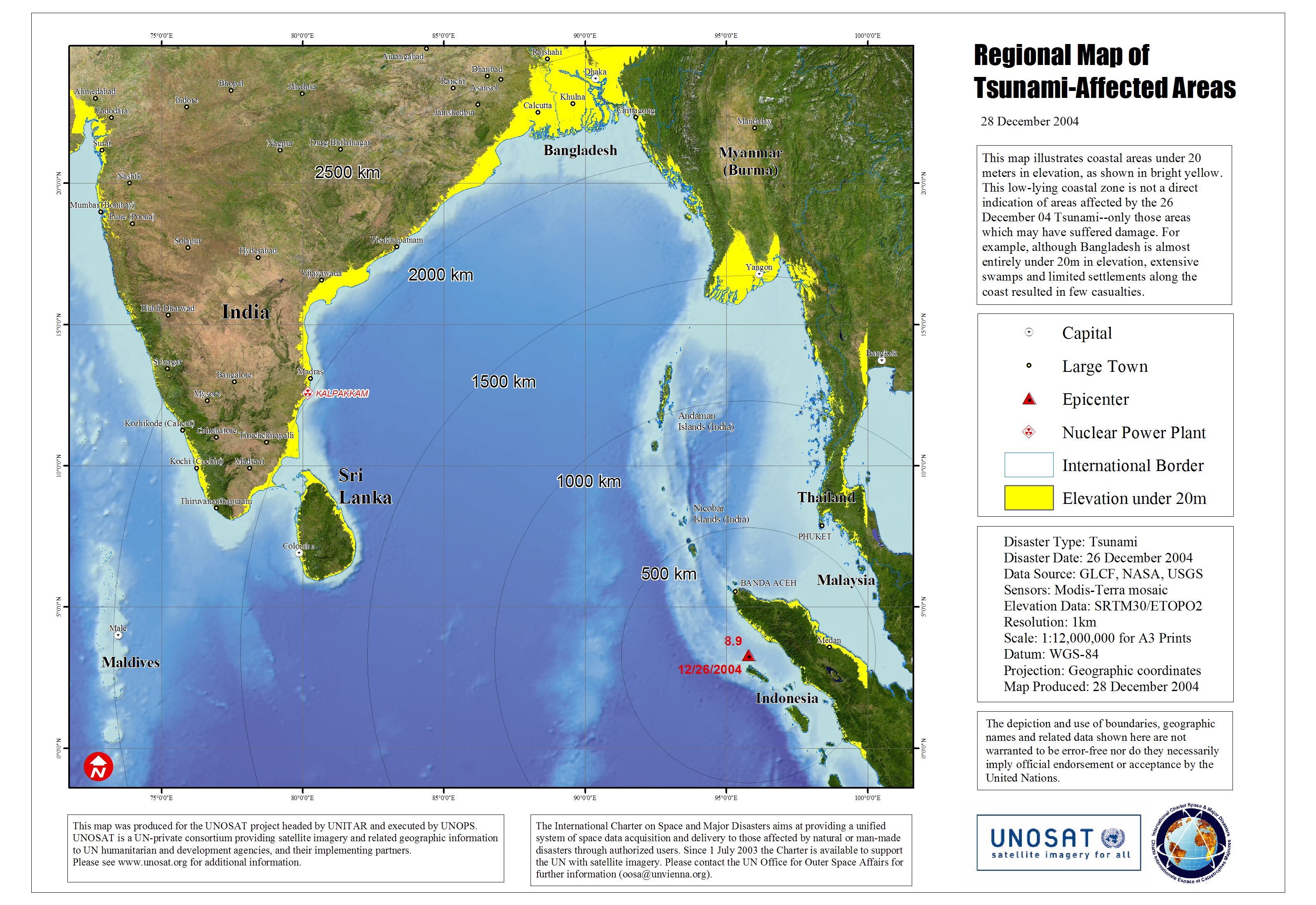
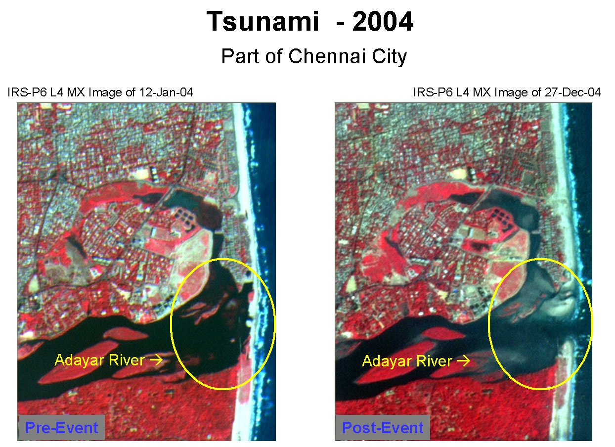
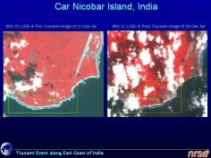
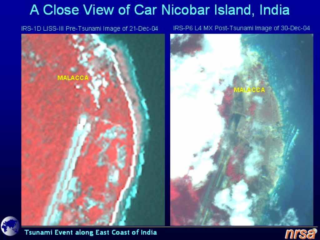
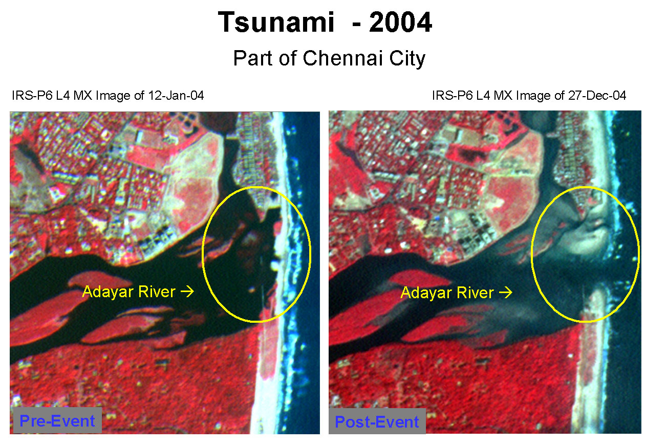
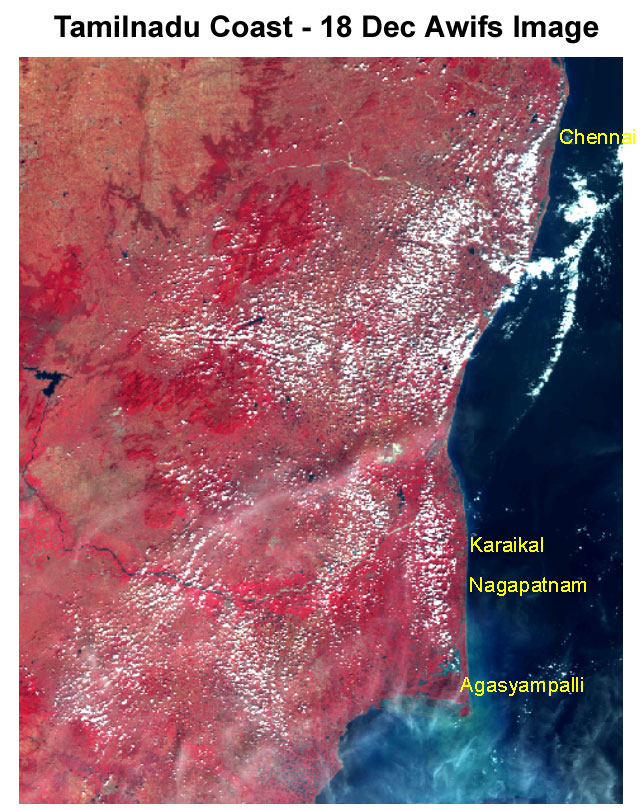
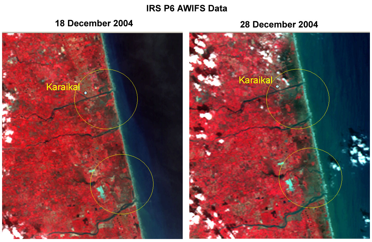
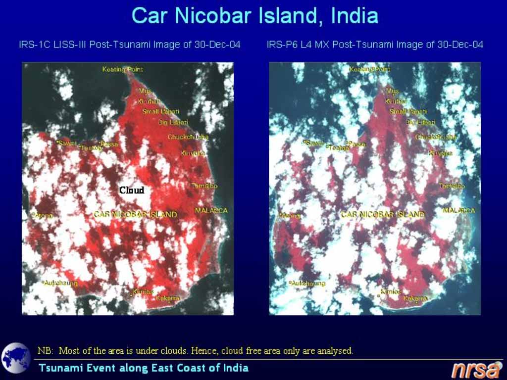
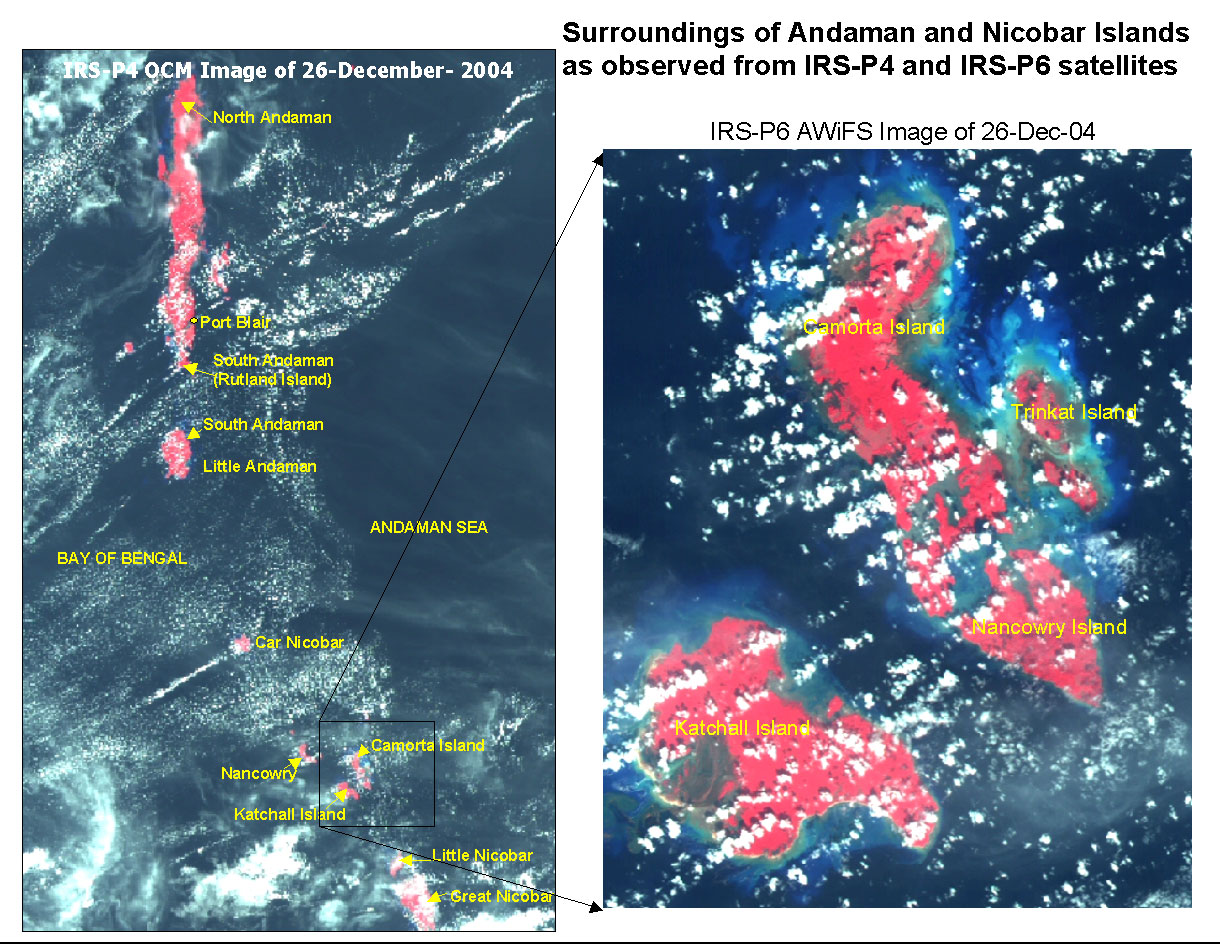
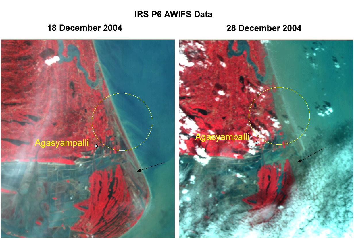
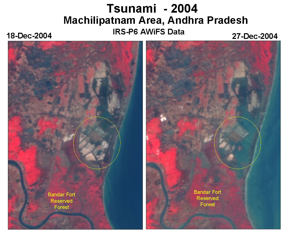
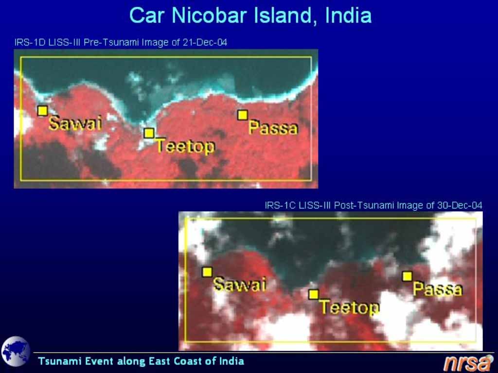
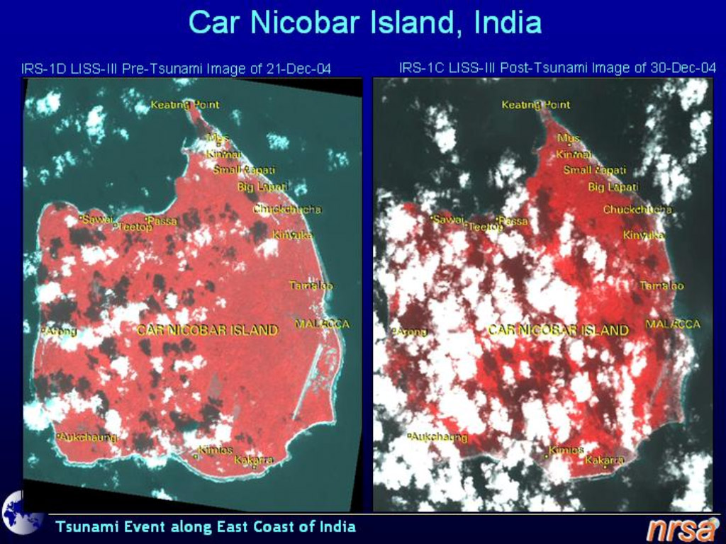
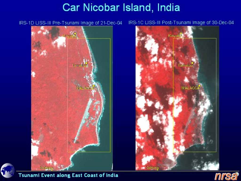
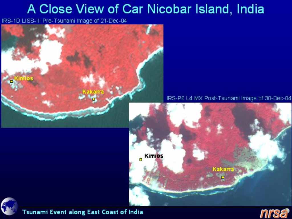
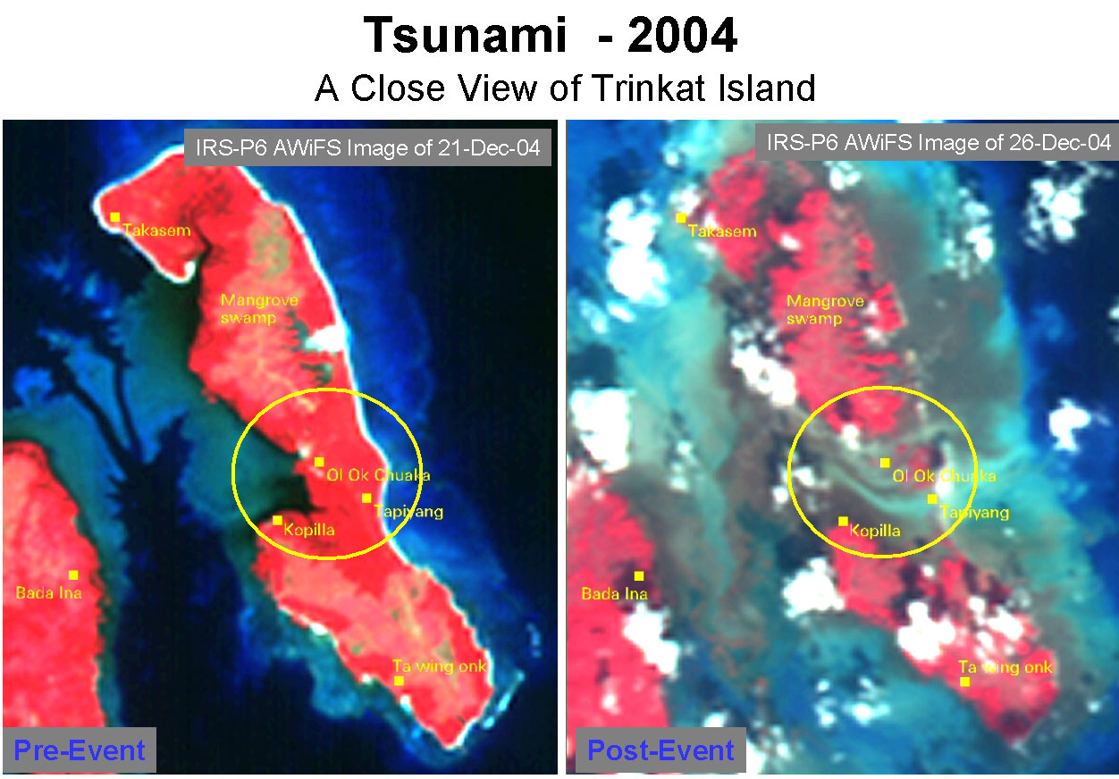
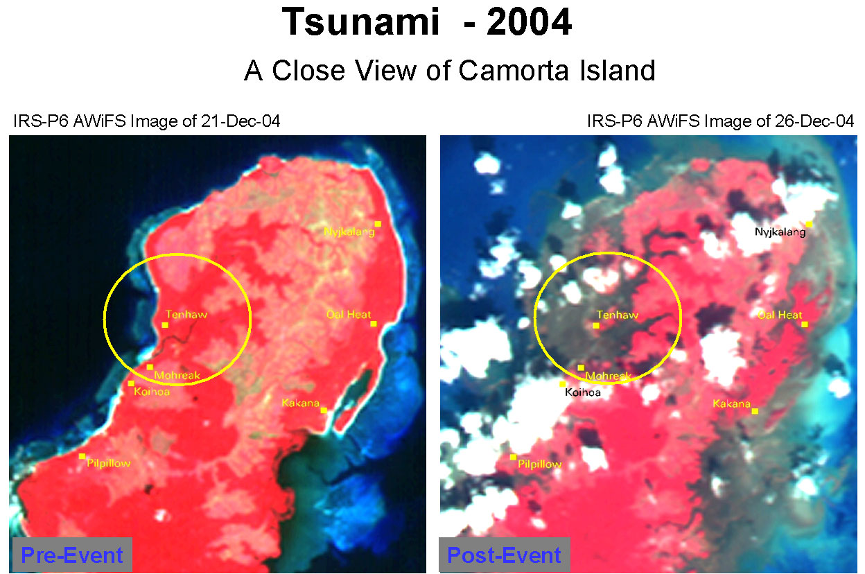
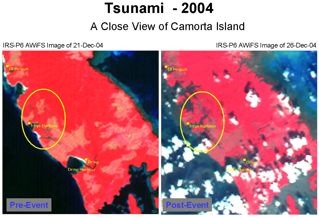
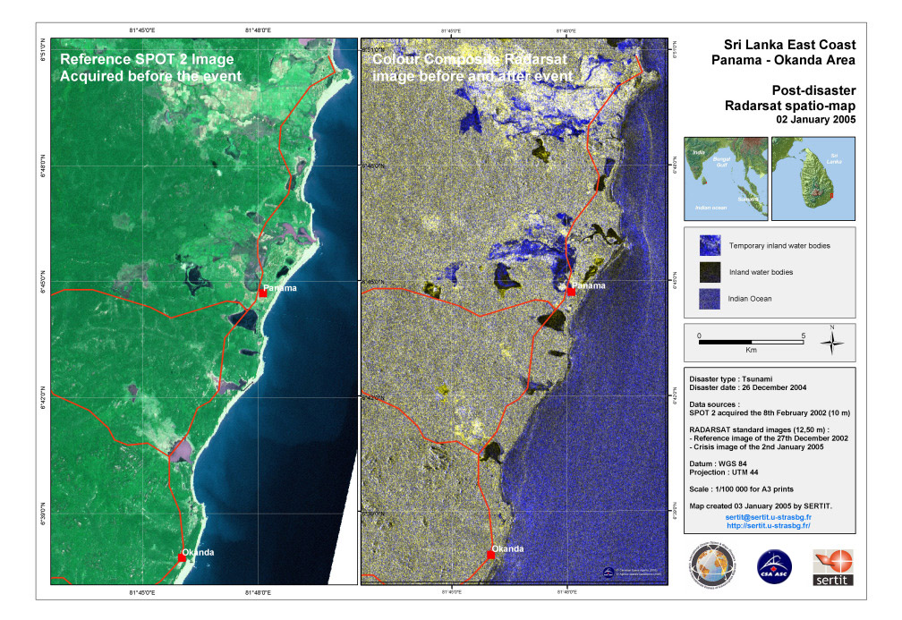
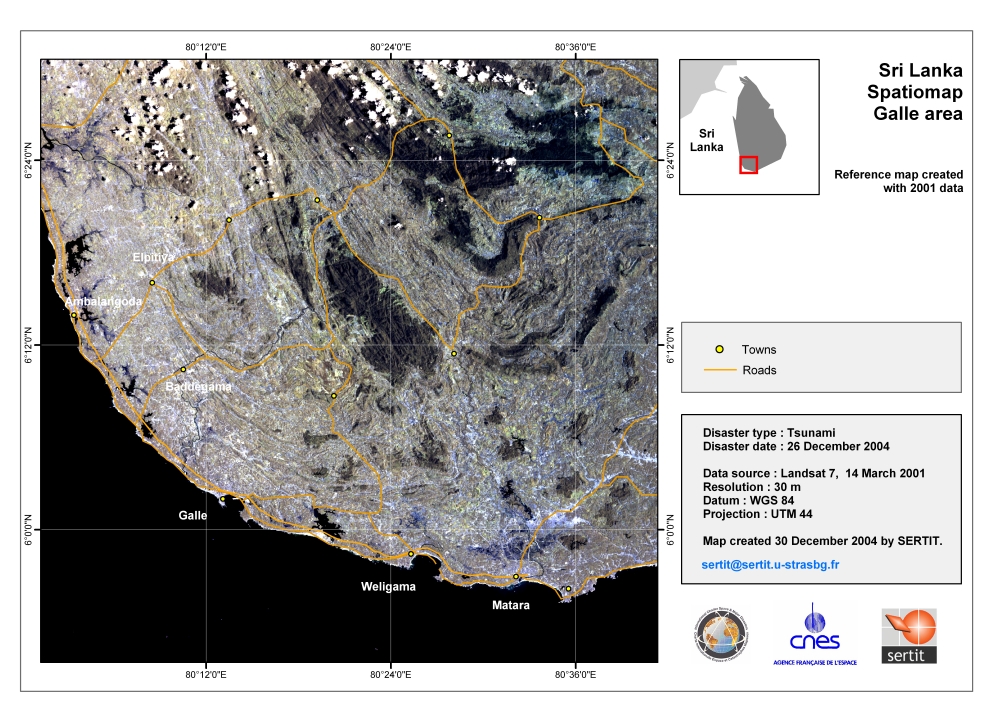
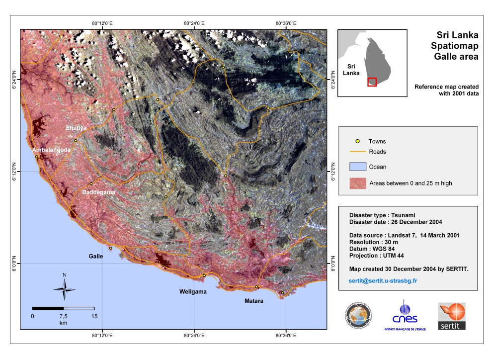
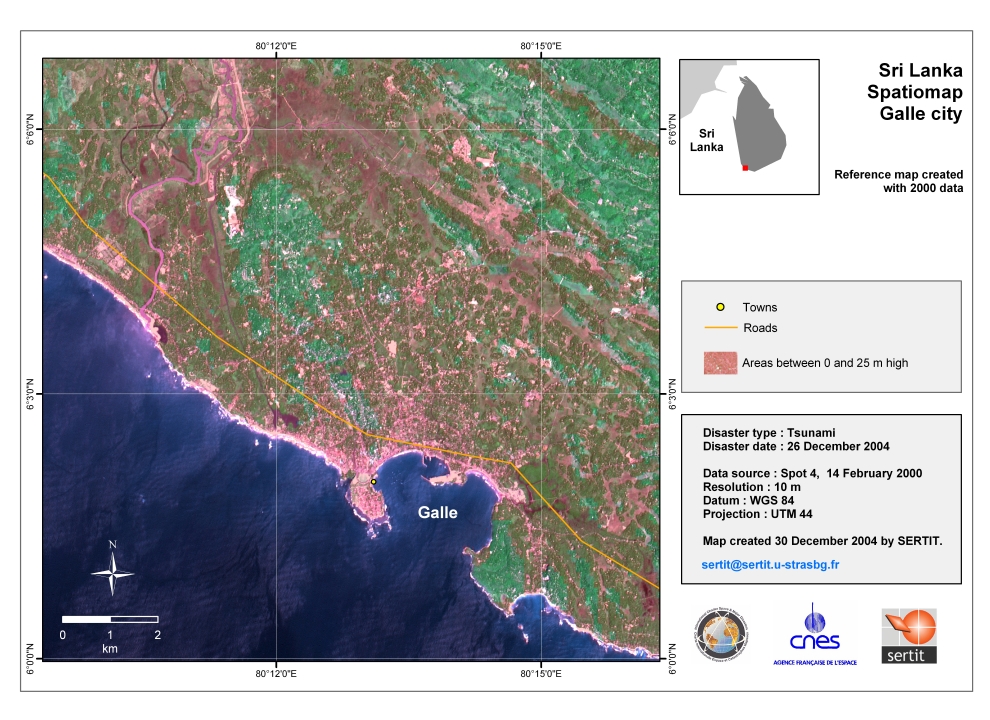
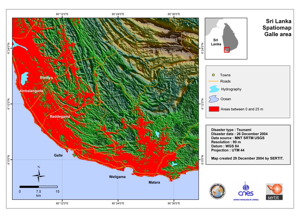
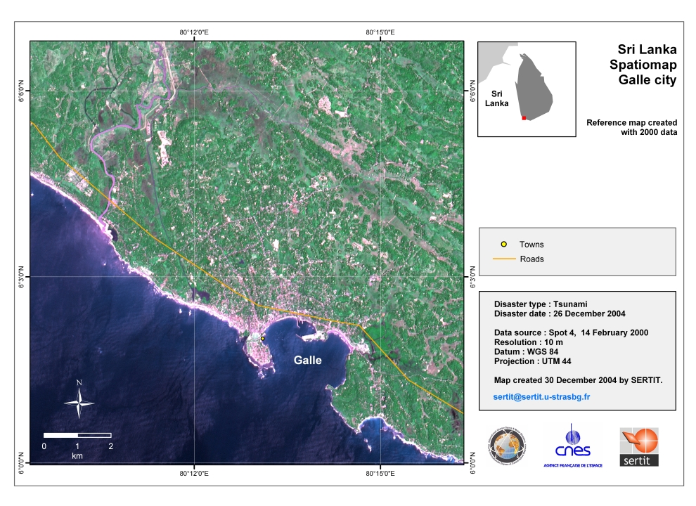
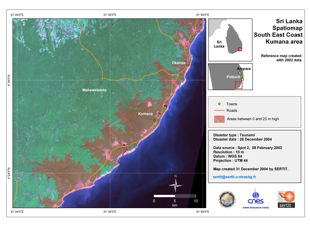
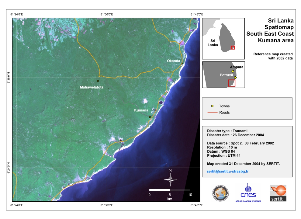
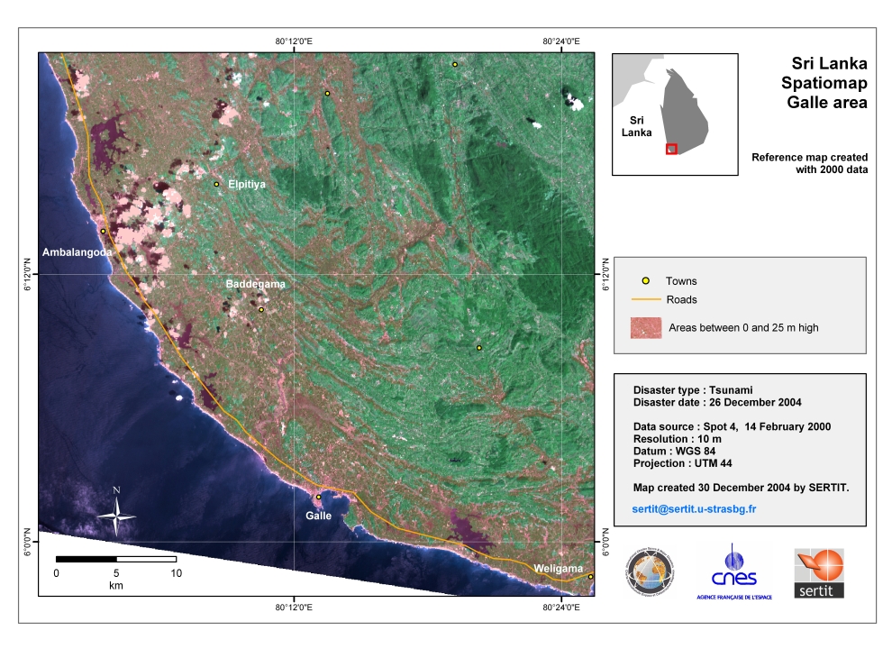
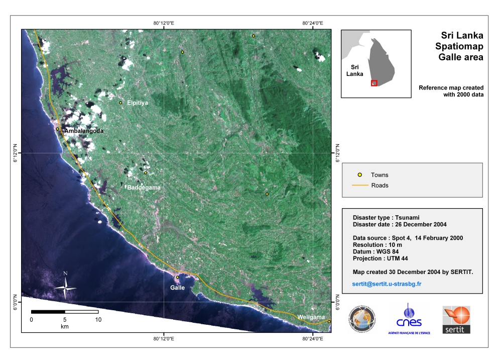
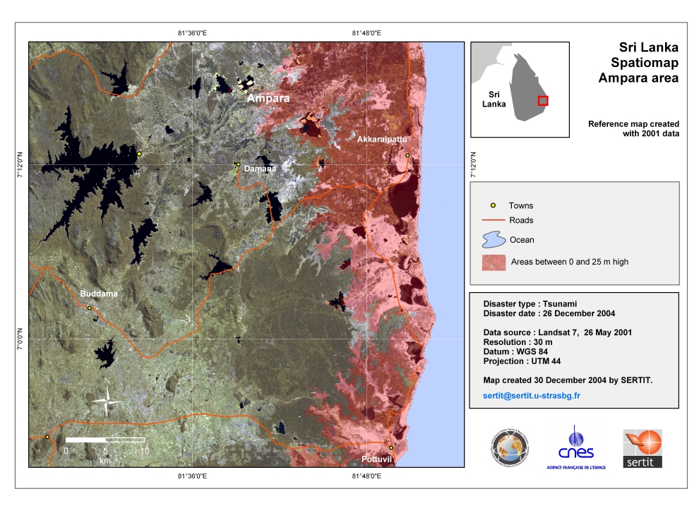
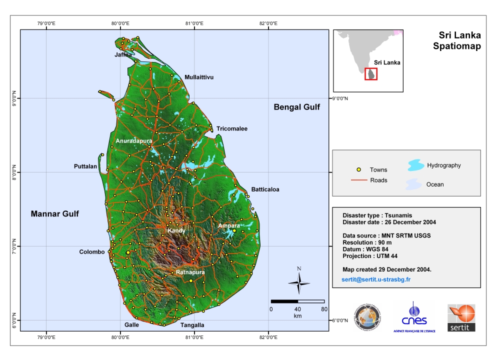
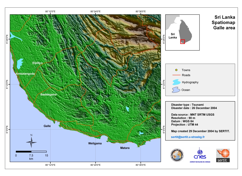
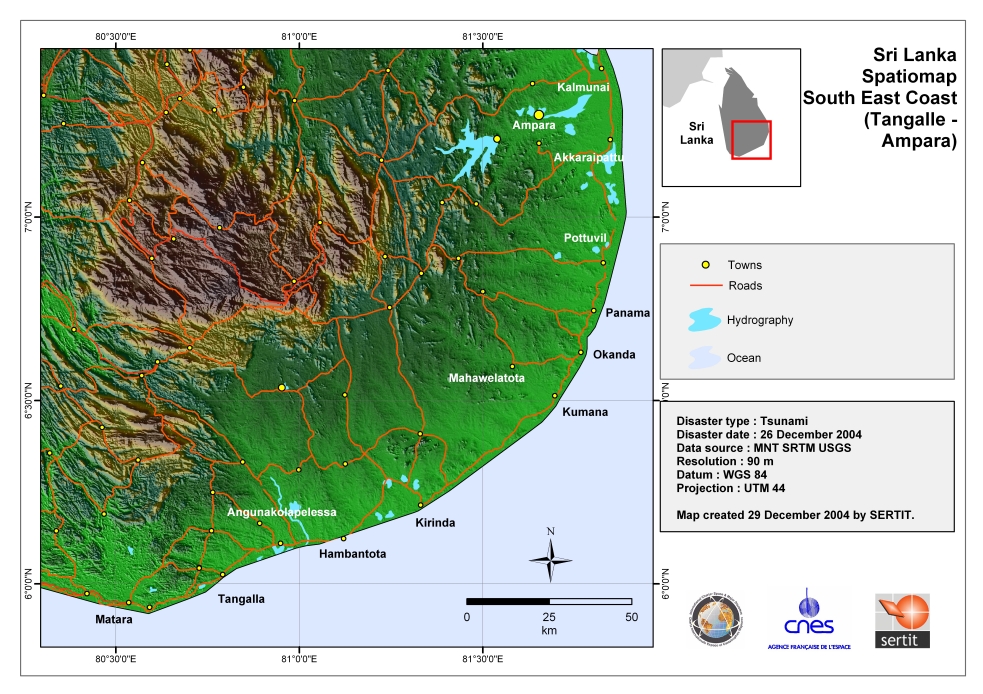
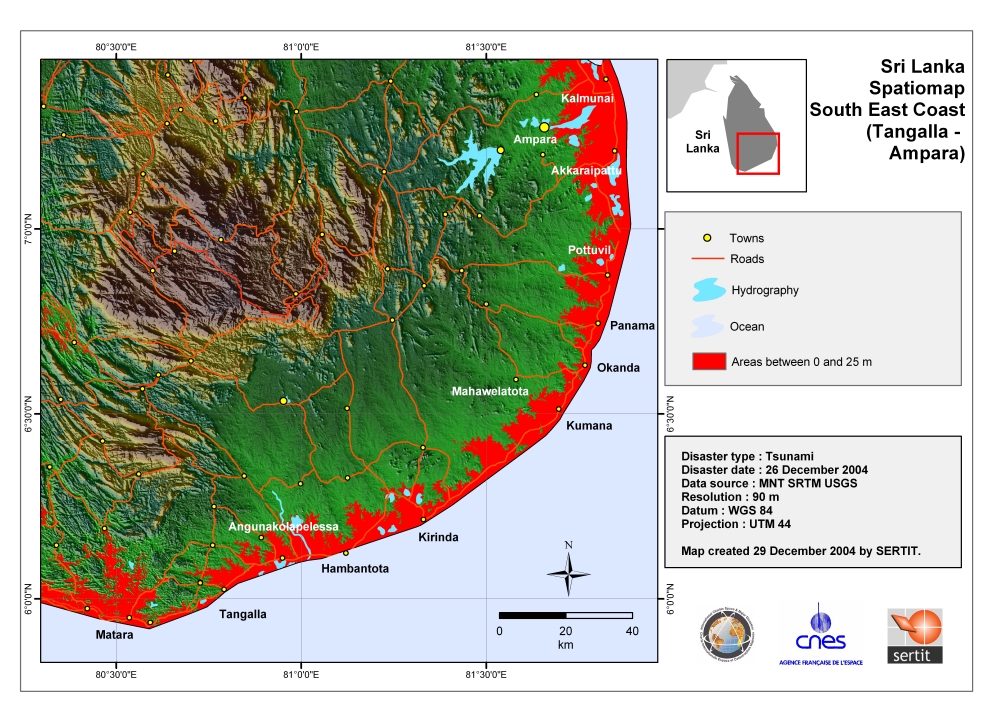
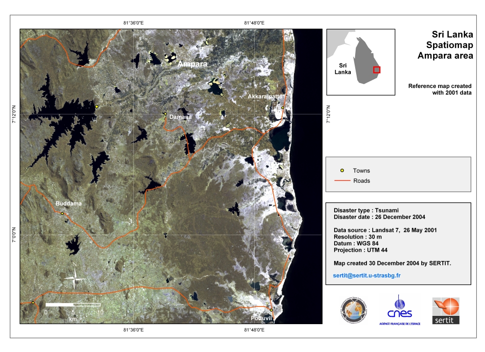
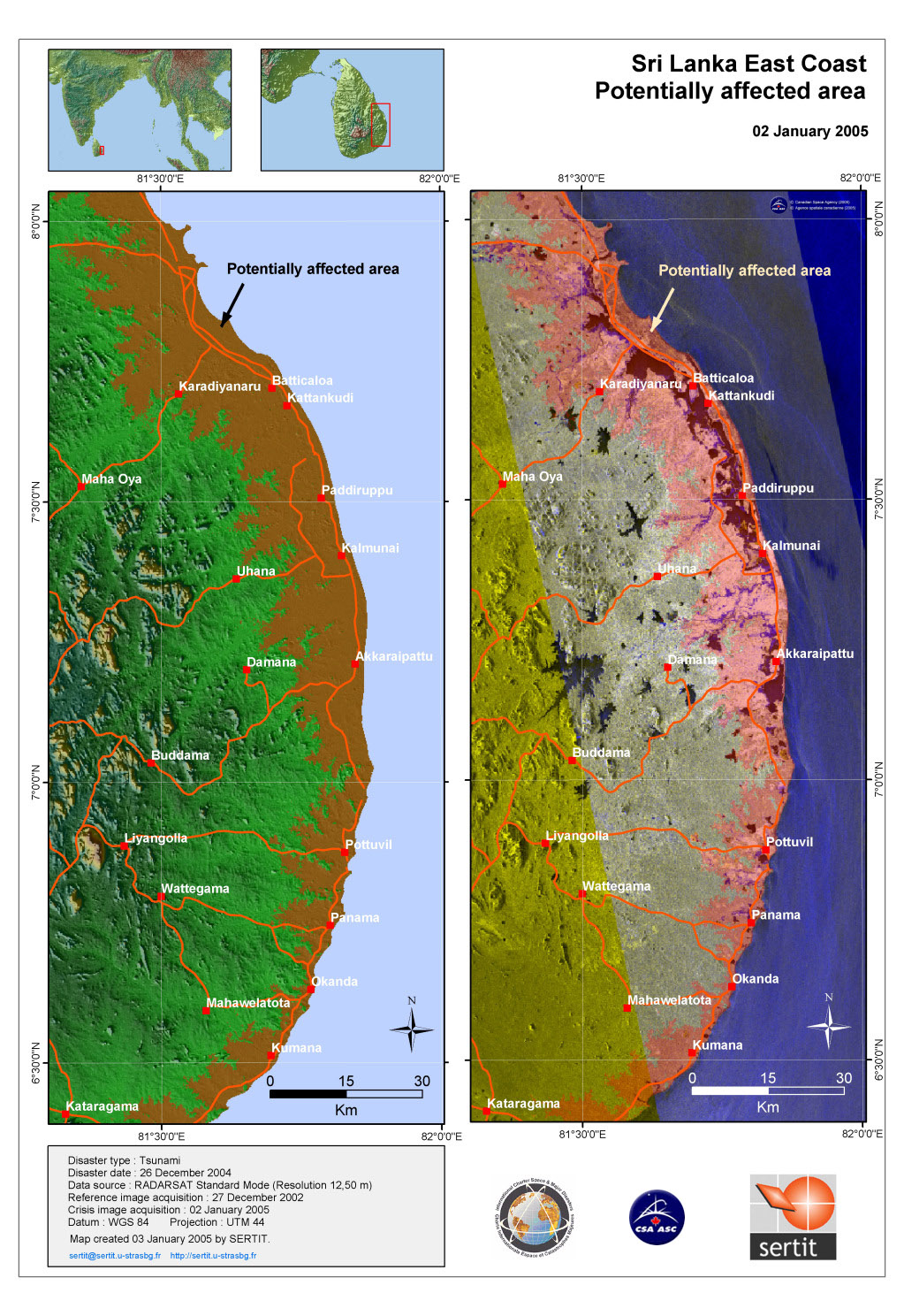
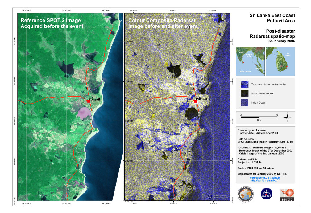
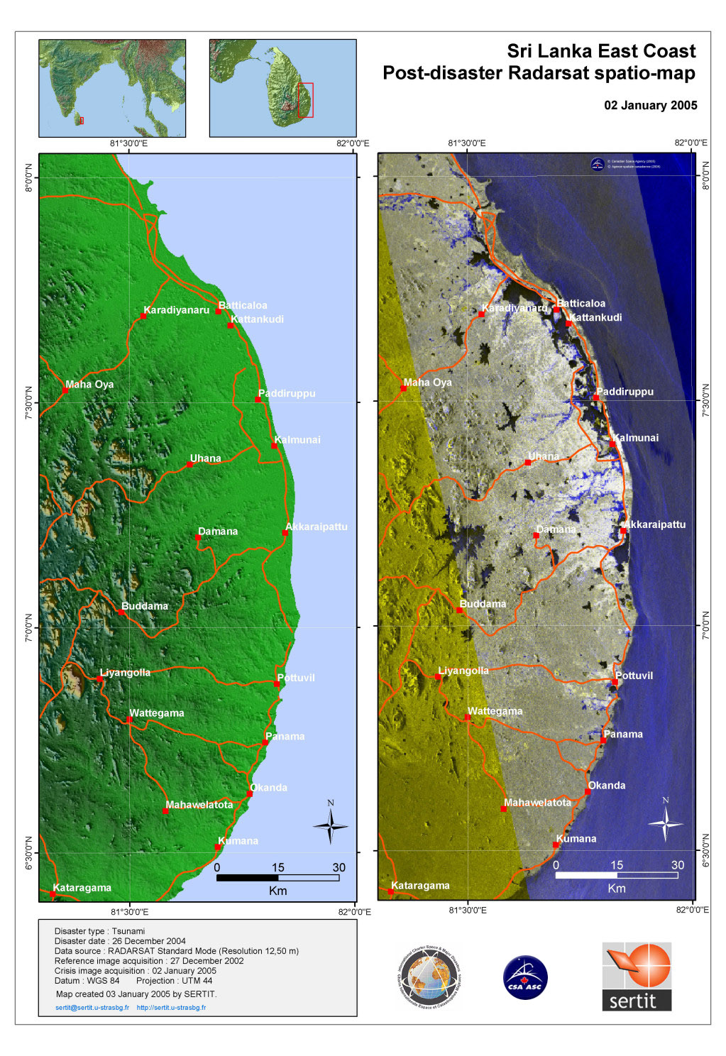
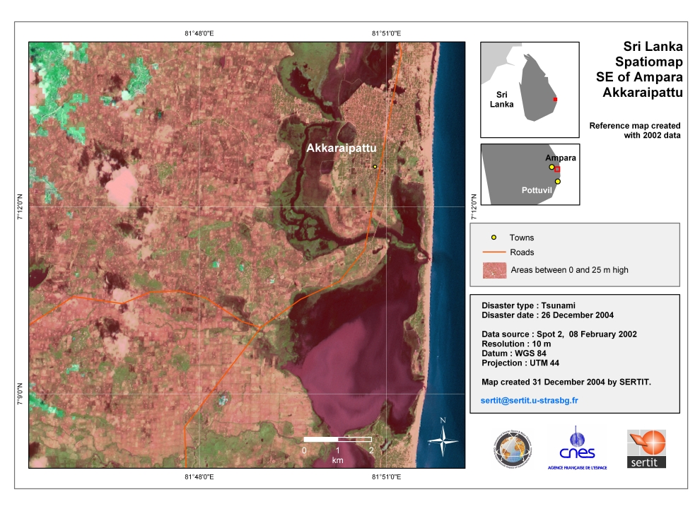
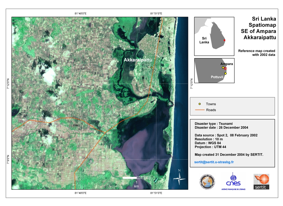
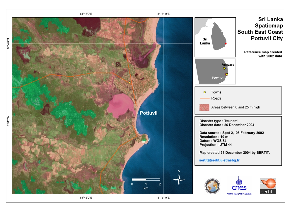
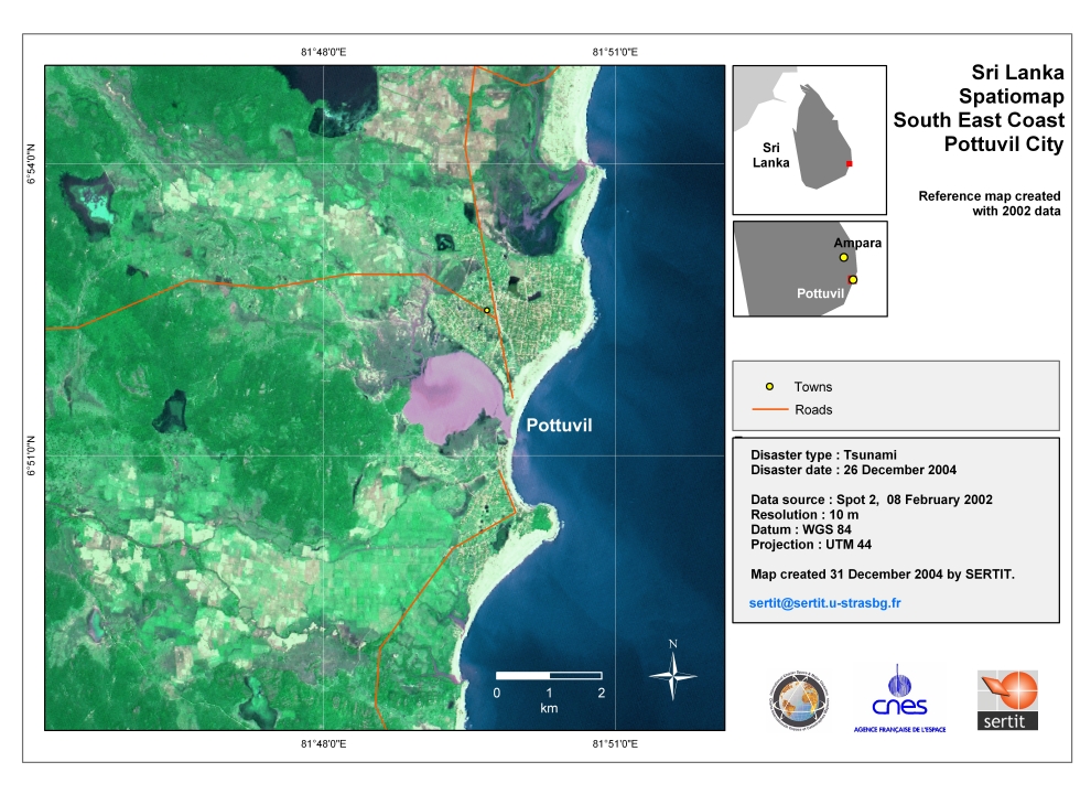
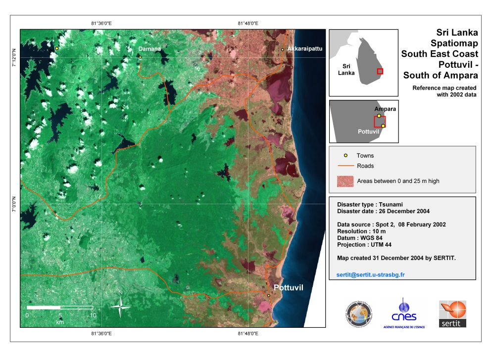
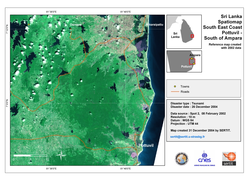
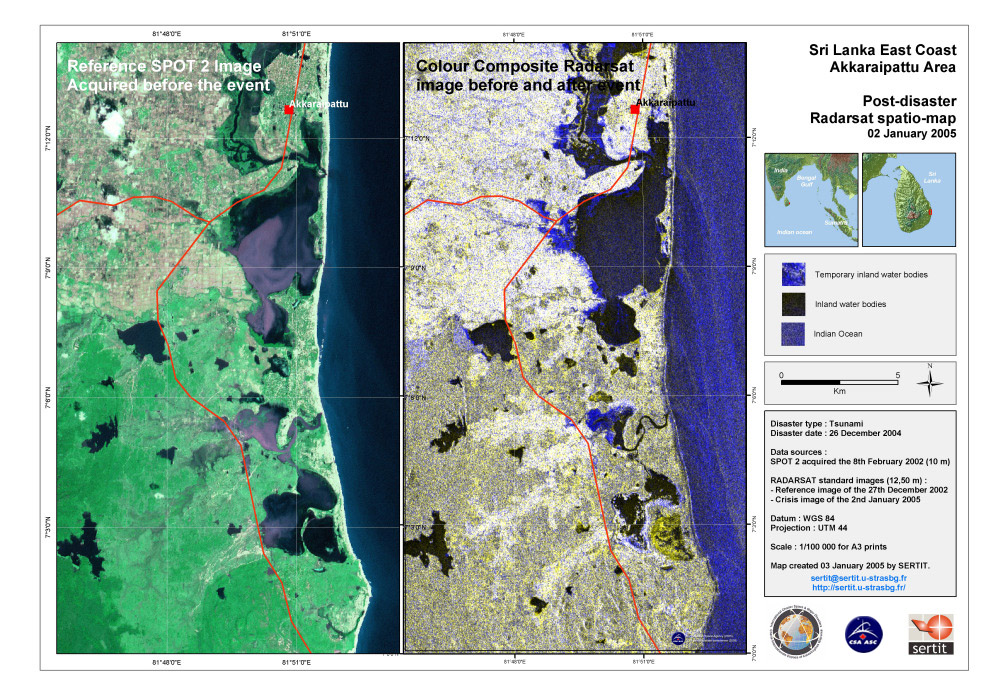
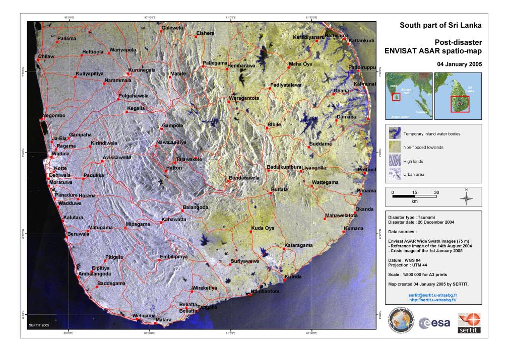
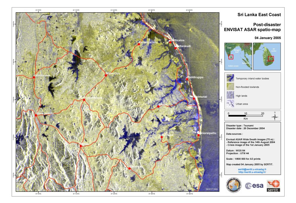
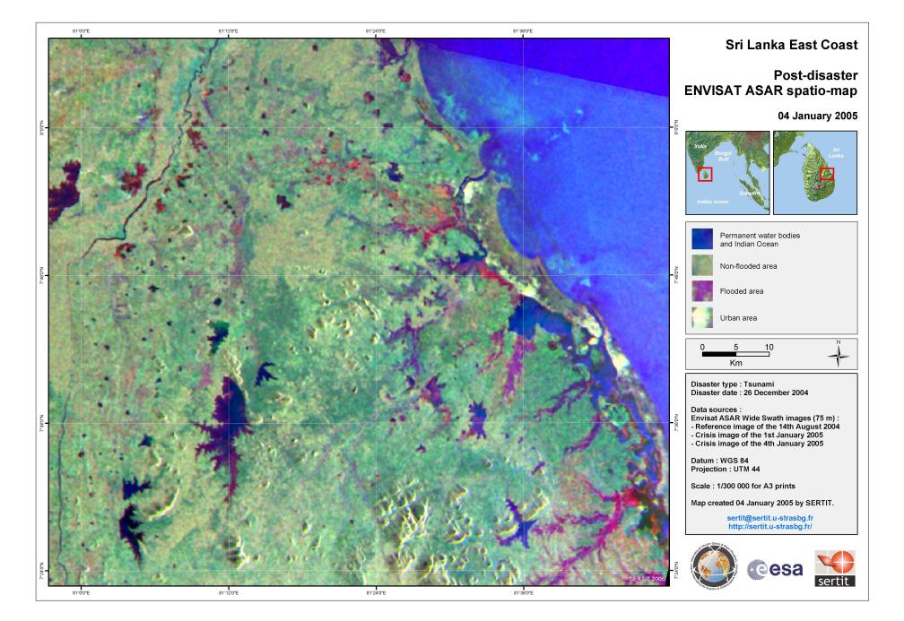
This is very much a partial list; the 500th activation of the Charter was on 1 August 2016.[12]

See also

References


  • Disaster Charter – Activation Details. Disasterscharter.org. Retrieved on 2011-03-13.

  • Disaster Charter – Recent Activations. Disasterscharter.org (2010-05-28). Retrieved on 2011-03-13.

  • "Saving lives from space". BBC News. Retrieved 8 October 2012.

  • http://www.disasterscharter.org/web/charter/activation_details?p_r_p_1415474252_assetId=ACT-482

  • /world-africa-29577175

  • "15 Years of International Cooperation on Disaster Response". International Charter Newsletter. International Charter Space and Major Disasters. 2015-12-31. p. 5. Retrieved 2016-05-07.

  • International Charter on Space and Major Disasters // International Symposium on Remote Sensing Applications to Natural Hazards, Washington, D.C. 12 September 2007, Barbara J. Ryan (Associate Director for Geography, U. S. Geological Survey)

  • http://www.disasterscharter.org/c/document_library/get_file?p_l_id=23109&folderId=172718&name=DLFE-4704.pdf

  • Roscosmos Acknowledged Full Member of International Charter on Space and Major Disasters // APRIL 23, 2014

  • Роскосмос — 15-й участник Международной хартии по космосу и крупным катастрофам (Russian space agency is 15th member of International Charter on Space and Major Disasters) // ГЕОМАТИКА. — 2013. — № 3. — С. 14-16. (GEOMATIKA 2013 №3 pages 14-16) (Russian)

  • "14th Annual Report". International Charter Space & Major Disasters. 2015-12-31. pp. 4–6. Retrieved 2016-05-07.

  • "500th activation of the International Charter" (Press release). International Charter on Space and Major Disasters. 1 August 2016. Retrieved 18 August 2016.

  • http://www.disasterscharter.org/web/charter/activation_details?p_r_p_1415474252_assetId=ACT-077

  • First Satellite Map of Haiti Earthquake, ScienceDaily

  • Spaceman: How satellites are being used in Haiti. BBC (2010-01-14). Retrieved on 2011-03-13.

  • (French) Plan Orsec – Wikipédia. Fr.wikipedia.org. Retrieved on 2011-03-13.

  • Disaster Charter – Earthquake in New Zealand. Disasterscharter.org. Retrieved on 2011-03-13.

  • Disaster Charter – Earthquake in Japan. Disasterscharter.org (2010-05-28). Retrieved on 2011-03-13.

  • "Disaster Charter - Typhoon Haiyan in the Philippines". Disasterscharter.org. Retrieved 2013-11-11.

  • "15 space organizations join hunt for missing Malaysian jet". CNET. Retrieved 11 October 2014.

  • Ebola epidemic in West Africa

  • "Global Ebola outbreak deaths exceed 4,000 - WHO". BBC News. 10 October 2014. Retrieved 11 October 2014.

  • "Latest Activation: Fire in Canada". International Charter on Space and Major Disasters. 4 May 2016. Retrieved 6 May 2016.

    1. "Flood in United States". International Charter on Space and Major Disasters. 14 August 2016. Retrieved 18 August 2016.

    External links

     This page was last modified on 8 January 2017, at 16:25.

    ###############
     
    The International Charter

    The International Charter aims at providing a unified system of space data acquisition and delivery to those affected by natural or man-made disasters through Authorized Users. Each agency member has committed resources to support the provisions of the Charter and thus is helping to mitigate the effects of disasters on human life and property.
     https://www.disasterscharter.org/web/guest/home

    Internationale Charta für Weltraum und Naturkatastrophen

    Die Internationale Charta für Weltraum und Naturkatastrophen (englisch Charter On Cooperation To Achieve The Coordinated Use Of Space Facilities In The Event Of Natural Or Technological Disasters), kurz Charter ‘Space and Major Disasters’ (Charter) ist eine Übereinkunft zwischen partizipierenden Raumfahrtagenturen, weltraumgestützte Daten und Informationen zur Unterstützung von Hilfsmaßnahmen in Katastrophenfällen zur Verfügung zu stellen.
    Die Charter ist einzigartig durch ihre Fähigkeit, Agenturen weltweit mit ihrem Knowhow und ihren Satelliten zu mobilisieren, und zwar kostenlos für den jeweiligen Nutzer. Dazu steht ein zentraler Zugriffspunkt an sieben Tagen die Woche rund um die Uhr zur Verfügung.
    Seit ihrer erfolgreichen Implementierung im November 2000 stellt die Charter immer wieder weltraumgestützte Daten nach plötzlichen Naturkatastrophen, wie Überschwemmungen, Wirbelstürmen, Tsunamis, Erdbeben, Erdrutschen, Waldbränden und Vulkanausbrüchen zur Verfügung, sowie auch nach industriellen Großunfällen oder großen Ölverschmutzungen.

    Geschichte

    Im Anschluss an die UNISPACE III Konferenz in Wien im Juli 1999, initiierten die Europäische und die Französische Weltraumagentur (ESA und CNES) die International Charter ‚Space and Major Disaster‘. Die Kanadische Weltraumagentur (CSA) schloss sich ihnen bald darauf an. Bis Herbst 2013 ist die Charter auf eine Gruppe von 15 Mitgliedern angewachsen, und Satellitendaten wurden zur Beobachtung von mehr als 400 Katastrophenereignissen seit dem Jahr 2000 eingesetzt. Die Anzahl der durch die Charter jährlich abgedeckten Katastrophen lag zuletzt bei mehr als 40 (Durchschnitt der Jahre 2007 bis 2013). Weitere Details und viele aus Satellitendaten abgeleitete Produkte und Karten können im "Activations Archive" auf der Website der Charter eingesehen werden.[1]

    Mitglieder

    Die folgenden 15 Raumfahrtagenturen sind derzeit Mitglieder der Charter und stellen im Rahmen von Charter-Aktivierungen Daten ihrer Erdbeobachtungs-Satelliten zur Verfügung:

    Organisation und Arbeitsweise

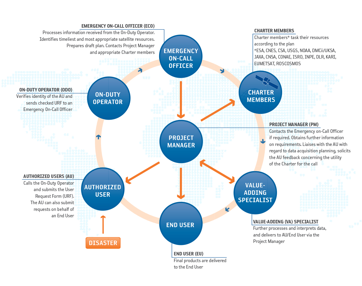
    Für jeden Katastrophentyp hat die Charter jeweils die für die Katastrophenhilfe nützlichsten Satellitensensoren und Aufnahmeoptionen identifiziert, die dann im konkreten Fall einer Charter-Aktivierung schnellstmöglich angefordert werden. Das Mandat der Charter beschränkt sich dabei auf die schnelle und kostenlose Bereitstellung von Satellitenaufnahmen, jedoch werden oft auch daraus abgeleitete Informationsprodukte wie Karten und Schadensbewertungen zur Verfügung gestellt. Neben neugewonnenen Daten werden auch Archivbilder so schnell wie möglich bereitgestellt, um Schäden im Vergleich der Satellitenbilder von vor und nach der Katastrophe zu visualisieren. Solche Informationen erlauben einen wertvollen Überblick über Gebiete, die am Boden nur schwer zugänglich sind, und helfen somit dabei, zerstörte Infrastruktur zu identifizieren und Gebiete ausfindig zu machen, in denen Hilfe besonders dringend benötigt wird. Die Charter wird von „autorisierten Nutzern“ - in der Regel nationale Katastrophenschutzbehörden - ausgelöst. Für jede Aktivierung der Charter wird ein Projekt Manager benannt, der die Bereitstellung hilfreicher Informationen an den Nutzer koordiniert.

    „Universal Access“-Initiative

    Mit dem Ziel, den Zugang zur Charter für Nutzer weltweit weiter zu erleichtern, haben sich die Mitgliedsagenturen auf das Prinzip des „Universal Access“ verständigt. Dies bedeutet, dass grundsätzlich jede nationale Katastrophenschutzbehörde weltweit in die Lage versetzt werden soll, ein Hilfegesuch an die Charter zu übermitteln. Dabei müssen festgelegte Abläufe befolgt werden, aber es spielt keine Rolle, ob der Notruf aus dem Land eines Charter-Mitglieds oder aus einem anderen Land kommt. Nationale Behörden können zum „autorisierten Nutzer“ der Charter werden, indem sie sich bei der Charter registrieren und an einem Training teilnehmen.

    Literatur

    Weblinks

    ACTIVATING THE CHARTER

    Activating the Charter

    There are several mechanisms to activate the Charter. It is based on a pre-defined list of appointed users, known as 'Authorized Users' (AUs). Until now AUs are typically disaster management authorities, from countries of Charter member agencies, able to request Charter support for emergencies in their own country, or in a country with which they cooperate for disaster relief.
    Since its inception, the Charter has demonstrated a strong commitment to expanding its number of users. Initiatives include collaboration with UNITAR/UNOSAT and UN OOSA, active in many countries and who can submit requests to support in-country UN relief agencies, and Sentinel Asia, a regional network for Earth observation-based Emergency Response in 32 countries.

    Universal Access

    Building on a decade of success in making satellite data available for disaster response, the International Charter is now opening its doors even wider. The Charter Members have adopted the principle of Universal Access to further strengthen the Charter's contribution to disaster management worldwide. Any national disaster management authority will be able to submit requests to the Charter for emergency response. Proper procedures will have to be followed, but the affected country will not have to be a Charter member.
    Universal Access benefits national disaster management authorities in countries beyond those of the Charter members, previously unable to make direct requests to the Charter.
    A registration process is in place for national authorities interested in participating in the Charter as an "Authorized User". This process will validate the ability of national authorities to access and use Charter assets for disaster response, in accordance with Charter operational procedures. Steps and applicable conditions are explained in the Charter's Universal Access Information Brochure available together with its Registration form.

    charter access
    Map showing countries (in dark blue) with direct access to the Charter in July 2016. Universal Access allows national users from new countries to directly submit emergency requests as Authorized Users. In addition the Charter collaborates with Sentinel Asia, a regional network for Earth observation-based Emergency response in 26 countries (87 national organisations) and 15 International Organizations, and with UNITAR/UNOSAT and UNOOSA, active in many countries and who can submit requests to support in-country relief agencies of the United Nations. All countries of the world can benefit from the Charter by any of the ways described above. Since 2000 there have been 499 disasters covered in 118 countries worldwide.

    Sequence of Events

    The following illustration depicts the sequence of events that occur once the Charter is activated. Beginning with the authorized user (bottom left), follow the sequence with your mouse for a brief description of each step, and click on any of the steps for more in-depth information.
    An Authorized User can call a single number to request the mobilization of the space and associated ground resources associated with Charter members in order to obtain data and information on a disaster occurrence.
    A 24-hour on-duty operator receives the call, checks the identity of the requestor and verifies that the User Request form, sent by the Authorized User, is correctly completed.
    The operator passes the information to an Emergency On-Call Officer who analyzes the request and the scope of the disaster with the Authorized User, and prepares an archive and acquisition plan using available satellite resources.
    Data acquisition and delivery takes place on an emergency basis, and a Project Manager, who is qualified in data ordering, handling and application, assists the user throughout the process.

    Charter Operational Loop

    charter loop


    Authorized Users (AU)

    Authorized User (AU)
    • They are the bodies authorized to request the services of the Charter
    • Typically they are national civil protection, rescue, defense and security bodies
    • They are recognized to be the Charter Associated Bodies
    • They receive the single (ODO) phone number
     
    Exceptionally, the Board may allow certain organizations with which the Charter Parties and Partner Agencies have an interest to cooperate, or 'Cooperating Bodies', to request the Charter data.
     

    On-Duty Operator (ODO)

    On-Duty Operator (ODO)
    • Available 24h/day, 7 days/week
    • Receives calls requesting space data images and information
    • Identifies the caller as being an AU
    • Obtains and confirms with the AU the information required
    • Transmits the information to the ECO (AU coordinates)
    • Contacts the ECO within an hour
     

    Emergency On-Call Officer (ECO)

    Emergency On-Call Officer (ECO)

    • Available 24h/day, 7 days/week
    • Processes the information received from the ODO
    • Verifies the validity of the disaster relief data request
    • Identifies the most timely and appropriate satellite resource and prepares a draft plan
    • Gets the Space Agency user's approval
    • AAP (Archives / Acquisition plan)
    • Tasks the appropriate Space Agency
    • Submits request for new images or archives
    • Gathers all relevant information in the dossier
    • Transfers dossier to the Project Manager
    • Informs Space Agencies of the status of their space resources

    Members (Space Agencies)

    Members (Space Agencies)
    • Plan acquisitions according to request submitted by ECO
    • Resolve any conflicts and suggest alternate acquisitions if necessary
    • Program their respective space resources (satellites) to acquire the requested data over the area affected by the disaster
    • Not all of the space resources can provide relevant data for all types of disasters.
    • Hence, not all of the space resources are necessarily tasked for each Charter request

    Value Added Reseller

    Space Resources (Satellites)
    • Once the data is acquired, it is processed into images
    • VA further processes and interprets the data acquired over the area affected by the disaster and delivers the images to the End User

    Project Manager (PM)

    Project Manager (PM)
    • Identified by Executive Secretariat when Charter is activated
    • Available during normal working hours
    • Ensures data is sent to the end user
    • Confirms accuracy of data sent to user
    • Ability to interpret data
    • Coordinates, when required, the delivery of value-added products and information
    • Completes dossier with a report submitted to the International Charter Executive Secretariat

    Mechanisms to activate the Charter

    There are several mechanisms for a user organisation to submit a request to activate the Charter:

    Direct activation

    A pre-defined list of appointed users, known as 'Authorized Users' (AUs), can submit a request for a disaster occurring in their country. The only bodies authorised to directly request the Charter to be activated are the AUs (typically civil protection agencies, governmental relief organisations, or other authorities with a mandate related to disaster management).

    Activation via an Authorised User on behalf of a user from a non-member country ('sponsor Authorised User')

    Authorised Users can access the Charter to request support for a disaster in a country with which they cooperate for relief purposes.

    Activation via the UN for UN users

    The Charter has an agreement with UN OOSA (Vienna) and UNITAR/UNOSAT (Geneva) to provide support to UN agencies. UN OOSA and UNITAR/UNOSAT may submit requests on behalf of users from the United Nations.

    Activation for Asia Pacific users via Sentinel Asia's partner, the Asian Disaster Reduction Centre

    Sentinel Asia is a regional collaboration for Earth observation based emergency response in 31 Asia Pacific countries.
    Since 2009 the Charter has granted the Asian Disaster Reduction Centre the right to submit activation requests on behalf of national users of Sentinel Asia.

    Further actions to improve Charter access with GEO

    In response to a request from the Group on Earth Observation (GEO) to improve access to the Charter during emergencies, collaboration has started with primary focus on users from African countries that do not have a direct access to the Charter. In 2009, the Charter initiated a formal user consultation to address the improvement of Charter access in African countries.

    Universal Access Information Brochure & User Registration Form

    Emergency related enquiries

    New users without direct access to the Charter should address emergency related enquiries to:
    executivesecretariat@disasterscharter.org

    General information enquiries

    General enquiries concerning the Charter operations and provisions should be addressed to:
    webmaster@disasterscharter.org

    CHARTER MEMBERS

    Charter Members
     

    Member

    Space Resources

    European Space Agency (ESA) ERS, Envisat, Sentinel-1A / B, Sentinel-2A, Proba-V
    Centre national d'études spatiales (CNES)
    Airbus Defence and Space SPOT, Pléiades
    Canadian Space Agency (CSA) RADARSAT
    Indian Space Research Organisation (ISRO) IRS
    National Oceanic and Atmospheric Administration (NOAA) POES, GOES
    Argentina's Comisión Nacional de Actividades Espaciales (CONAE) SAC-C
    Japan Aerospace Exploration Agency (JAXA) ALOS
    United States Geological Survey (USGS) Landsat
    Digital Globe Quickbird
    GeoEye GeoEye-1
    UK Space Agency & DMC International Imaging (DMCii) UK-DMC
    Centre National des Techniques Spatiales (Algeria) ALSAT-1
    National Space Research and Development (Nigeria) NigeriaSat
    Tübitak-BILTEN (Turkey) BILSAT-1
    China National Space Administration (CNSA) FY, SJ, ZY satellite series
    German Aerospace Center (DLR) TerraSAR-X, TanDEM-X
    Korea Aerospace Research Institute (KARI) KOMPSAT-2, KOMPSAT-3, KOMPSAT-5
    National Institute For Space Research (INPE) CBERS
    European Organisation for the Exploitation of Meteorological Satellites (EUMETSAT) Meteosat and Metop satellite series
    The State Space Corporation Roscosmos (Roscosmos) RESURS-DK1, RESURS-P, METEOR-М №1, KANOPUS-V
    Agencia Bolivariana Para Actividades Espaciales (ABAE) VRSS-1

    CHARTER ACTIVATIONS


    Tsunami, Indonesia and Thailand

     https://www.disasterscharter.org/web/guest/-/tsunami-indonesia-and-thail-45

    Tuesday, 28 December 2004

     Type of Event:
    Tsunami, Earthquake
    Location of Event:
    Indonesia and Thailand
    Date of Charter Activation:
    27/12/2004
    Charter Requestor:
    UNOOSA on behalf of UNOPS
    Project Management:
    UNOSAT

    Description of the event

    On December 26, 2004, an earthquake of magnitude 9.0 struck off the west coast of Sumatra in the Indonesian Archipelago. This earthquake triggered a devastating tsunami and caused tremors that killed over 104,000 people in Indonesia and over 5,000 in Thailand.
    Indonesia was the worst affected followed by Sri Lanka, India, Thailand, Somalia, Maldives, Malaysia and Myanmar.


    QuickBird Image, 23 June 2004

    Source: --
    Acquired: --

    Copyright: --

    Other info: --

    Satellite map of Banda Aceh Damage.

    Source: GLCF, JPL, Global Insight; SPOT 5.
    Acquired: --

    Copyright: Map produced 30/12/2004 by UNOSAT.

    QuickBird Image, 28 December 2004

    Source: --
    Acquired: --

    Copyright: --

    Other info: --

    QuickBird Image, 6 June 2004

    Source: --
    Acquired: --

    Copyright: ---

    Other info: --

    QuickBird Image, 23 June 2004

    Source: --
    Acquired: --

    Copyright: --

    Other info: --

    QuickBird Image, 28 December 2004

    Source: --
    Acquired: --

    Copyright: --

    Other info: --

    Thailand Khao Lak north

    Source: Ikonos images, 30/01/2003 and 29/12/2004, before and after the devastating tsunami.
    Acquired: 30/01/2003 and 29/12/2004

    Copyright: Remote Sensing Data Centre, DLR - German Aerospace Center Ikonos imagery provided through Center for Remote Imaging, Sensing and Processing, Space Imaging.
    Scale 1:12.500 Map created 30 December 2004 by zki@dlr.de

    Other info: --

    Thailand Phuket

    Source: Scale 1:75,000 Landsat imagery, 15/01/2002.
    Acquired: 15/01/2002.

    Copyright: German Remote Sensing Data Centre, DLR - German Aerospace Center
    Map created 30 December 2004 by zki@dlr.de

    Indonesia, Medan, Scale 1:75,000

    Source: Landsat images, 02/02/2002, 22/02/2001, and 14/05/2001.
    Acquired: 02/02/2002, 22/02/2001, and 14/05/2001.

    Copyright: German Remote Sensing Data Centre, DLR - German Aerospace Center
    Map created 30 December 2004 by zki@dlr.de

    Indonesia Aceh, Scale 1:5000

    Source: Ikonos images, 30/01/2003 and 29/12/2004, before and after the devastating tsunami.
    Acquired: 30/01/2003 and 29/12/2004

    Copyright: German Remote Sensing Data Centre, DLR - German Aerospace Center Ikonos imagery provided through Center for Remote Imaging, Sensing and Processing, Space Imaging.
    Scale 1:12.500 Map created 30 December 2004 by zki@dlr.de

    Indonesia aceh, Scale 1:75,000

    Source: Landsat imagery, 08/05/2000
    Acquired: 08/05/2000

    Copyright: German Remote Sensing Data Centre, DLR - German Aerospace Center
    Map created 30 December 2004 by zki@dlr.de

    Satellite map of Banda Aceh region, scale: 1:200,000.

    Source: GLCF, JPL, Global Insight.
    Acquired: 8 Mai 2000

    Copyright: Landsat ETM data acquired 8 May 2000, bands 7/4/2, 28 m resolution Elevation data: SRTM (3 arc seconds). Shows coastal areas under 30 meters elevation.

    Elevation map of Phuket Island, scale: 1:100,000.

    Source: GLCF, JPL, USGS, Global Insight. Elevation data: SRTM (3 arc seconds). Shows coastal areas under 20 meters elevation.
    Acquired: --

    Copyright: Map produced 29/12/2004 by UNOSAT.

    Other info: --

    Population density map of Banda Aceh region, scale: 1:200,000.

    Source: GLCF, JPL, Global Insight. Elevation data: SRTM (3 arc seconds). Population data: LandScan 2002. Shows coastal areas under 30 meters elevation.
    Acquired: --

    Copyright: Map produced 28/12/2004 by UNOSAT.

    Other info: --

    Satellite map of Aceh Etm.

    Source: GLCF, JPL, Global Insight; Landsat.
    Acquired: --

    Copyright: Map produced 01/01/2005 by UNOSAT.

    Satellite map of Banda Aceh Damage.

    Source: GLCF, JPL, Global Insight; SPOT 5.
    Acquired: --

    Copyright: Map produced 01/01/2005 by UNOSAT.

    Satellite map of Banda Aceh Damage.

    Source: GLCF, JPL, Global Insight; SPOT 5.
    Acquired: --

    Copyright: Map produced 30/12/2004 by UNOSAT.

    Satellite map of Phuket Envisat MERIS RGB Overview.

    Source: ESA; Envisat MERIS.
    Acquired: 27 December 2004

    Copyright: Map produced 04/01/2005 by UNOSAT.

    Dendron Poster: Sumatra.

    Source: --
    Acquired: --

    Copyright: --

    Dendron Poster: Banda Aceh.

    Source: --
    Acquired: --

    Copyright: --

    Satellite map of Aceh Coast Landsat ETM.

    Source: GLCF, JPL, Global Insight; Landsat.
    Acquired: --

    Copyright: Map produced 01/01/2005 by UNOSAT

    Satellite map of Aceh Coast Landsat ETM.

    Source: GLCF, JPL, Global Insight; Landsat.
    Acquired: --

    Copyright: Map produced 01/01/2005 by UNOSAT.

    Satellite map of Phuket Island, scale: 1:100,000.

    Source: GLCF, JPL, Global Insight. Landsat ETM data acquired 8 Jan 2002, bands 7/4/2, 28 m resolution Elevation data: SRTM (3 arc seconds). Shows coastal areas under 20 meters elevation.
    Acquired: 8 Jan 2002

    Copyright: Map produced 29/12/2004 by UNOSAT.

    Other info: --

    Population density map of Island, scale: 1:100,000.

    Source: GLCF, JPL, Global Insight. Elevation data: SRTM (3 arc seconds). Population data: LandScan 2002. Shows coastal areas under 20 meters elevation.
    Acquired: --

    Copyright: Map produced 29/12/2004 by UNOSAT.

    Other info: --

    Satellite map of Aceh Coast Landsat ETM.

    Source: GLCF, JPL, Global Insight; Landsat.
    Acquired: --

    Copyright: Map produced 01/01/2005 by UNOSAT

    Other info: --

    Satellite map of Banda-aceh ETM

    Source: GLCF, JPL, Global Insight; Landsat.
    Acquired: --

    Copyright: Map produced 01/01/2005 by UNOSAT

    Satellite map of Aceh Coast Landsat ETM.

    Source: GLCF, JPL, Global Insight; Landsat.
    Acquired: --

    Copyright: Map produced 01/01/2005 by UNOSAT

    Satellite map of Aceh Coast Landsat ETM

    Source: GLCF, JPL, Global Insight; Landsat.
    Acquired: --

    Copyright: Map produced 01/01/2005 by UNOSAT.

    Satellite map of Aceh Coast Landsat ETM.

    Source: GLCF, JPL, Global Insight; Landsat.
    Acquired: --

    Copyright: Map produced 01/01/2005 by UNOSAT.

    Satellite map of Aceh Coast.

    Source: GLCF, JPL, Global Insight; Landsat.
    Acquired: --

    Copyright: Map produced 01/01/2005 by UNOSAT.

    Satellite map of Aceh Elevation at 200 dpi.

    Source: GLCF, JPL, Global Insight; Landsat.
    Acquired: --

    Copyright: Map produced 01/01/2005 by UNOSAT.

    Indonesia Aceh

    Source: Scale 1:5000 Ikonos images, 30/01/2003 and 29/12/2004, before and after the devastating tsunami. Scale 1:12.500
    Acquired: 30/01/2003 and 29/12/2004

    Copyright: German Remote Sensing Data Centre, DLR - German Aerospace Center Ikonos imagery provided through Center for Remote Imaging, Sensing and Processing, Space Imaging.
    Map created 30 December 2004 by zki@dlr.de

    QuickBird Image, 28 December 2004

    Source: --
    Acquired: --

    Copyright: --

    Other info: --

    Indonesia Aceh, Scale 1:5000, before and after the devastating tsunami.

    Source: Ikonos
    Acquired: 30/01/2003 and 29/12/2004

    Copyright: Map created 30 December 2004 by zki@dlr.de German Remote Sensing Data Centre, DLR - German Aerospace Center Ikonos imagery provided through Center for Remote Imaging, Sensing and Processing, Space Imaging.

    Medan, Scale 1:75,000

    Source: Landsat imagery, archived data.
    Copyright: German Remote Sensing Data Centre, DLR - German Aerospace Center
    Map created 30 December 2004 by zki@dlr.de

    QuickBird Coverage, 28 December 2004

    Source: --
    Acquired: --

    Copyright: --

    Other info: --

    QuickBird Image, 28 December 2004

    Source: --
    Acquired: --

    Copyright: --

    Other info: --

    QuickBird Image, 28 December 2004

    Source: --
    Acquired: --

    Copyright: --

    Other info: --

    Medan, Scale 1:75,000

    Source: Ikonos images, 30/01/2003 and 29/12/2004, before and after the devastating tsunami.
    Acquired: 30/01/2003 and 29/12/2004

    Copyright: German Remote Sensing Data Centre, DLR - German Aerospace Center Ikonos imagery provided through Center for Remote Imaging, Sensing and Processing, Space Imaging.
    Scale 1:12.500 Map created 30 December 2004 by zki@dlr.de

    Medan Region, Scale 1:75,000

    Source: Landsat imagery, DLR SRTM elevation data.
    Copyright: German Remote Sensing Data Centre, DLR - German Aerospace Center
    Map created 30 December 2004 by zki@dlr.de

    QuickBird Image, 28 December 2004

    Source: --
    Acquired: --

    Copyright: --

    Other info: --

    QuickBird Image, 23 June 2004

    Source: --
    Acquired: --

    Copyright: --

    Other info: --

    QuickBird Image, 28 December 2004

    Source: --
    Acquired: --

    Copyright: --

    Other info: --

    Elevation map of Banda Aceh region, scale: 1:200,000.

    Source: GLCF, JPL, Global Insight. Elevation data: SRTM (3 arc seconds). Shows coastal areas under 30 meters elevation.
    Acquired: --

    Copyright: Map produced 28/12/2004 by UNOSAT.

    Thailand Khao Lak

    Source: Scale 1:100,000 Landsat imagery, 15/01/2002.
    Acquired: 15/01/2002.

    Copyright: German Remote Sensing Data Centre, DLR - German Aerospace Center
    Map created 30 December 2004 by zki@dlr.de

    Medan, Scale 1:75,000

    Source: Landsat
    Acquired: 02/02/2002, 22/02/2001, 14/05/2001

    Copyright: Map created 30 December 2004 by zki@dlr.de German Remote Sensing Data Centre, DLR - German Aerospace Center

    High resolution AVI sequences: (Indeo codec required)

    ##############

    Earthquake, Tsunami in Southern Asia

     https://www.disasterscharter.org/web/guest/-/earthquake-tsunami-in-southern-as-6

     Sunday, 26 December 2004

    Type of Event:
    Earthquake, tsunami
    Location of Event:
    India; Sri Lanka, Thailand, Indonesia, Maldives, Malaysia, Myanmar (Burma)
    Date of Charter Activation:
    26/12/2004
    Charter Requestor:
    Project Management:
    ISRO, NRSA; UNOOSA, CNES

    Description of the event

    A high-magnitude earthquake, 9.0 on the Richter scale, struck southern Asia at 00:58 UTC, 6:58 AM local time. The epicentre was 320 km west of Medan, just off the west coast of the Indonesian island of Sumatra. The earthquake was followed by tsunamis that killed nearly a quarter of a million people, mostly in Indonesia, Sri Lanka, and India. The coastal regions of India, Sri Lanka, Thailand, Indonesia, Maldives, Malaysia, and Myanmar were all severely affected. Bangladesh, the Seychelles, Somalia, Kenya, and Tanzania also suffered damage and loss of life.
    Before and after tsunami satellite images, Tarangambadi Surroundings Tamil Nadu

    Source: Envisat SAR data, 29/12/04 and 01/01/05
    Acquired: 01/01/05

    Copyright: Courtesy National Remote Sensing Agency, Govt. of India

    Regional Topographic map, with affected areas, population density and digital elevation model.

    Source: UNJLC
    Topographic map of Sumatra, with affected areas, population density and digital elevation model.

    Source: UNJLC.
    Carte topographique régionale, montrant des zones touchées, densité de la population et modèle numérique du terrain.

    Source: Centre de logistique des Nations Unies.
    Potential population affected by Tsunami over the whole area.

    Source: European Commission, Joint Research Institute.
    Copyright: Population density data from Landscan 2002 Elevation data from SRTM (NASA)

    Regional map of countries most affected by the Tsunami. Show zones under 30 meters elevation.

    Source: UNOSAT, USGS, NASA (SRTM30/ETOPO2/MODIS), Global Insight.
    Post-tsunami satellite map, IRS Before After Tsunami Karaikal India

    Source: IRS-P6 AWiFS data
    Acquired: 02/01/2005

    Copyright: Map produced 02/01/2005 by UNOSAT

    Before and after tsunami satellite images, Katchall

    Source: IRS-P6 AWiFS data, 21/12/04, 26/12/04, and IRS-P6 LISS-III data, 04/01/05
    Acquired: 21/12/04, 26/12/04, 04/01/05

    Copyright: Courtesy National Remote Sensing Agency, Govt. of India

    Before and after tsunami satellite images, Pumpukar Surroundings Tamil Nadu

    Source: Envisat SAR data, 29/12/04 and 01/01/05
    Acquired: 01/01/05

    Copyright: Courtesy National Remote Sensing Agency, Govt. of India

    Before and after tsunami satellite images, Great Nicobar Patitiya Nicobar Islands

    Source: IRS-P6 AWiFS data, 21/12/04, and Radarsat SAR data, 31/12/04
    Acquired: 21/12/04, 31/12/04

    Copyright: Courtesy National Remote Sensing Agency, Govt. of India

    Before and after tsunami satellite images, Great Nicobar Pulobaha Nicobar Islands

    Source: IRS-P6 AWiFS data, 21/12/04, and Radarsat SAR data, 31/12/04
    Acquired: 21/12/04, 31/12/04

    Copyright: Courtesy National Remote Sensing Agency, Govt. of India

    Post-tsunami satellite map, IRS Before After Tsunami Agasympalli India

    Source: IRS-P6 AWiFS data
    Acquired: 02/01/2005

    Copyright: Map produced 02/01/2005 by UNOSAT

    Post-tsunami satellite map, IRS Before After Tsunami Chennai Indiar

    Source: IRS-P6 AWiFS data
    Acquired: 02/01/2005

    Copyright: Map produced 02/01/2005 by UNOSAT

    Post-tsunami satellite map, IRS Before After Tsunami Trinkat Nicobar

    Source: IRS-P6 AWiFS data
    Acquired: 02/01/2005

    Copyright: Map produced 02/01/2005 by UNOSAT

    Post-tsunami satellite map, Malacca Nicobar

    Source: Landsat ETM, 08/08/1999 and SPOT 5 data, 2.5 m resolution, 29/12/2004
    Acquired: 01/01/2005

    Copyright: Map produced 01/01/2005 by UNOSAT

    Post-tsunami satellite map, Maldives Gulhi

    Source: SPOT 5 data, 2.5 m resolution.
    Acquired: 31/12/2004

    Copyright: Map produced 31/12/2004 by UNOSAT

    Post-tsunami satellite map, IRS Before After Tsunami North Camorta Nicobar

    Source: IRS-P6 AWiFS data
    Acquired: 02/01/2005

    Copyright: Map produced 02/01/2005 by UNOSAT

    Post-tsunami satellite map, IRS Before After Tsunami North Center Nicobar

    Source: IRS-P6 AWiFS data
    Acquired: 02/01/2005

    Copyright: Map produced 02/01/2005 by UNOSAT

    Post-tsunami satellite map, IRS Before After Tsunami North Katchall Nicobar

    Source: IRS-P6 AWiFS data
    Acquired: 02/01/2005

    Copyright: Map produced 02/01/2005 by UNOSAT

    Post-tsunami satellite map, Maldives Dhigafinolhu

    Source: SPOT 5 data, 2.5 m resolution.
    Acquired: 31/12/2004

    Copyright: Map produced 31/12/2004 by UNOSAT

    Post-tsunami satellite map, Maldives Guralahu

    Source: SPOT 5 data, 2.5 m resolution.
    Acquired: 31/12/2004

    Copyright: Map produced 31/12/2004 by UNOSAT

    Post-tsunami satellite map, Maldives Mafushi

    Source: SPOT 5 data, 2.5 m resolution.
    Acquired: 31/12/2004

    Copyright: Map produced 31/12/2004 by UNOSAT

    Before and after tsunami satellite images, Kerala

    Source: IRS-1D LISS data, 19/12/04 and 27/12/04
    Acquired: 27/12/04

    Copyright: Courtesy National Remote Sensing Agency, Govt. of India

    Before and after tsunami satellite images, Tottapalli, Kerala

    Source: IRS-1D LISS data, 19/12/04 and 27/12/04
    Acquired: 27/12/04

    Copyright: Courtesy National Remote Sensing Agency, Govt. of India

    Before and after tsunami satellite images, Paravur, Kerala

    Source: IRS-1D LISS data, 19/12/04 and 27/12/04
    Acquired: 27/12/04

    Copyright: Courtesy National Remote Sensing Agency, Govt. of India

    Before and after tsunami satellite images, Chirayinkil, Kerala

    Source: IRS-1D LISS data, 19/12/04 and 27/12/04
    Acquired: 27/12/04

    Copyright: Courtesy National Remote Sensing Agency, Govt. of India

    Before and after tsunami satellite images, Trinkat

    Source: IRS-P6 AWiFS data, 21/12/04, 26/12/04, and IRS-P6 LISS-III data, 04/01/05
    Acquired: 21/12/04, 26/12/04, 04/01/05

    Copyright: Courtesy National Remote Sensing Agency, Govt. of India

    Before and after tsunami satellite images, Nicobar

    Source: IRS-P6 AWiFS data, 21/12/04, 26/12/04, and IRS-P6 LISS-III data, 04/01/05
    Acquired: 21/12/04, 26/12/04, 04/01/05

    Copyright: Courtesy National Remote Sensing Agency, Govt. of India

    Before and after tsunami satellite images, Camorta

    Source: IRS-P6 AWiFS data, 21/12/04, 26/12/04, and IRS-P6 LISS-III data, 04/01/05
    Acquired: 21/12/04, 26/12/04, 04/01/05

    Copyright: Courtesy National Remote Sensing Agency, Govt. of India

    Before and after tsunami satellite images, Camorta

    Source: IRS-P6 AWiFS data, 21/12/04, 26/12/04, and IRS-P6 LISS-III data, 04/01/05
    Acquired: 21/12/04, 26/12/04, 04/01/05

    Copyright: Courtesy National Remote Sensing Agency, Govt. of India

    Before and after tsunami satellite images, Nancowry

    Source: IRS-P6 AWiFS data, 21/12/04, 26/12/04, and IRS-P6 LISS-III data, 04/01/05
    Acquired: 21/12/04, 26/12/04, 04/01/05

    Copyright: Courtesy National Remote Sensing Agency, Govt. of India

    Before and after tsunami satellite images, Male, Maldives

    Source: IRS-P6 LISS-IV MX data, 09/02/04, IRS 1D PAN, 03/01/05
    Acquired: 03/01/05

    Copyright: Courtesy National Remote Sensing Agency, Govt. of India

    Before and after tsunami satellite images, Huhule, Maldives

    Source: IRS-P6 LISS-IV MX data, 09/02/04, IRS 1D PAN, 03/01/05
    Acquired: 03/01/05

    Copyright: Courtesy National Remote Sensing Agency, Govt. of India

    Before and after tsunami satellite images, Tamil Nadu Coast Tamil Nadu

    Source: IRS-P6 LISS-III data, 15/08/04 and Envisat SAR data, 29/12/04
    Acquired: 29/12/04

    Copyright: Courtesy National Remote Sensing Agency, Govt. of India

    Before and after tsunami satellite images, Pondicherry Tamil Nadu

    Source: IRS-P6 LISS-III data, 15/08/04 and Envisat SAR data, 29/12/04
    Acquired: 29/12/04

    Copyright: Courtesy National Remote Sensing Agency, Govt. of India

    Before and after tsunami satellite images, Cuddalore Tamil Nadu

    Source: IRS-P6 LISS-III data, 15/08/04 and Envisat SAR data, 29/12/04
    Acquired: 29/12/04

    Copyright: Courtesy National Remote Sensing Agency, Govt. of India

    Before and after tsunami satellite images, Tirumullaivasal Tamil Nadu

    Source: IRS-P6 LISS-III data, 15/08/04 and Envisat SAR data, 29/12/04
    Acquired: 29/12/04

    Copyright: Courtesy National Remote Sensing Agency, Govt. of India

    Before and after tsunami satellite images, Pumpukar Tamil Nadu

    Source: IRS-P6 LISS-III data, 15/08/04 and Envisat SAR data, 29/12/04
    Acquired: 29/12/04

    Copyright: Courtesy National Remote Sensing Agency, Govt. of India

    Before and after tsunami satellite images, Tarangambadi Tamil Nadu

    Source: IRS-P6 LISS-III data, 15/08/04 and Envisat SAR data, 29/12/04
    Acquired: 29/12/04

    Copyright: Courtesy National Remote Sensing Agency, Govt. of India

    Before and after tsunami satellite images, Karaikal Tamil Nadu

    Source: IRS-P6 LISS-III data, 15/08/04 and Envisat SAR data, 29/12/04
    Acquired: 29/12/04

    Copyright: Courtesy National Remote Sensing Agency, Govt. of India

    Before and after tsunami satellite images, Nagappattinam Tamil Nadu

    Source: IRS-P6 LISS-III data, 15/08/04 and Envisat SAR data, 29/12/04
    Acquired: 29/12/04

    Copyright: Courtesy National Remote Sensing Agency, Govt. of India

    Before and after tsunami satellite images, Nagappattinam Surroundings Tamil Nadu

    Source: IRS-P6 LISS-III data, 15/08/04 and merged image IRS LISS-III, 15/08/04 and Envisat SAR data, 29/12/04
    Acquired: 29/12/04

    Copyright: Courtesy National Remote Sensing Agency, Govt. of India

    Before and after tsunami satellite images, Vedaranniyam Tamil Nadu

    Source: IRS-P6 LISS-III data, 15/08/04 and Envisat SAR data, 29/12/04
    Acquired: 29/12/04

    Copyright: Courtesy National Remote Sensing Agency, Govt. of India

    Before and after tsunami satellite images, Vedaranniyam Surroundings Tamil Nadu

    Source: IRS-P6 LISS-III data, 15/08/04 and Envisat SAR data, 29/12/04
    Acquired: 29/12/04

    Copyright: Courtesy National Remote Sensing Agency, Govt. of India

    Before and after tsunami satellite images, Pumpukar Surroundings Tamil Nadu

    Source: Envisat SAR data, 29/12/04 and 01/01/05
    Acquired: 01/01/05

    Copyright: Courtesy National Remote Sensing Agency, Govt. of India

    Before and after tsunami satellite images, Karaikal Surroundings Tamil Nadu

    Source: Envisat SAR data, 29/12/04 and 01/01/05
    Acquired: 01/01/05

    Copyright: Courtesy National Remote Sensing Agency, Govt. of India

    Before and after tsunami satellite images, Nagappattinam Surroundings Tamil Nadu

    Source: Envisat SAR data, 29/12/04 and 01/01/05
    Acquired: 01/01/05

    Copyright: Courtesy National Remote Sensing Agency, Govt. of India

    Before and after tsunami satellite images, Nagappattinam Surroundings Tamil Nadu

    Source: Envisat SAR data, 29/12/04 and 01/01/05
    Acquired: 01/01/05

    Copyright: Courtesy National Remote Sensing Agency, Govt. of India

    Before and after tsunami satellite images, View Of Nicobar Islands

    Source: IRS-P6 AWiFS data, 21/12/04, 26/12/04, and Radarsat SAR data, 31/12/04
    Acquired: 21/12/04, 26/12/04, 31/12/04

    Copyright: Courtesy National Remote Sensing Agency, Govt. of India

    Before and after tsunami satellite images, Little Nicobar Pulo Milo Nicobar Islands

    Source: IRS-P6 AWiFS data, 21/12/04, and Radarsat SAR data, 31/12/04
    Acquired: 21/12/04, 31/12/04

    Copyright: Courtesy National Remote Sensing Agency, Govt. of India

    Before and after tsunami satellite images, Little Nicobar Kola Auva Nicobar Islands

    Source: IRS-P6 AWiFS data, 21/12/04, and Radarsat SAR data, 31/12/04
    Acquired: 21/12/04, 31/12/04

    Copyright: Courtesy National Remote Sensing Agency, Govt. of India

    Before and after tsunami satellite images, Great Nicobar Nicobar Islands

    Source: IRS-P6 AWiFS data, 21/12/04, and Radarsat SAR data, 31/12/04
    Acquired: 21/12/04, 31/12/04

    Copyright: Courtesy National Remote Sensing Agency, Govt. of India

    Before and after tsunami satellite images, Great Nicobar Pulo Kunji Nicobar Islands

    Source: IRS-P6 AWiFS data, 21/12/04, and Radarsat SAR data, 31/12/04
    Acquired: 21/12/04, 31/12/04

    Copyright: Courtesy National Remote Sensing Agency, Govt. of India

    Before and after tsunami satellite images, Great Nicobar Kopenheat Nicobar Islands

    Source: IRS-P6 AWiFS data, 21/12/04, and Radarsat SAR data, 31/12/04
    Acquired: 21/12/04, 31/12/04

    Copyright: Courtesy National Remote Sensing Agency, Govt. of India

    Regional Topographic map, with affected areas, population density and digital elevation model

    Source: UNJLC
    Potential land affected by Tsunami over the whole area.

    Copyright: European Commission, Joint Research Institute. Regional land cover map generated by a partnership coordinated by JRC, part of Global Land Cover 2000 project.


    Source: IRS-P6 AWiFs imagery 21/12/2004-26/12/2004, before and after tsunami
    Copyright: Courtesy National Remote Sensing Agency, Govt. of India


    Source: IRS-P6 L4 MX imagery 12/01/2004-27/12/2004, before and after tsunami
    Copyright: Courtesy National Remote Sensing Agency, Govt. of India


    Source: IRS-P6 L4 MX imagery 12/01/2004-27/12/2004, before and after tsunami
    Copyright: Courtesy National Remote Sensing Agency, Govt. of India

    Regional map of tsunami-affected areas, scale: 1:12,000,000

    Source: GLCF, NASA, USGS. MODIS-Terra Mosaic SRTM (3 arc seconds). Shows coastal areas under 20 meters elevation. Map produced 28/12/2004 by UNOSAT.
    Other info: Elevation data: SRTM (3 arc seconds). Shows coastal areas under 20 meters elevation. Map produced 28/12/2004 by UNOSAT.


    Source: IRS-P6 L4 MX imagery 12/01/2004-27/12/2004, before and after tsunami
    Copyright: Courtesy National Remote Sensing Agency, Govt. of India


    Source: IRS-1D LISS-III imagery, 21/12/2004, IRS-1C LISS-III imagery, 30/12/2004, Car Nicobar Island
    Copyright: Courtesy National Remote Sensing Agency, Govt. of India.


    Source: IRS-1D LISS-III imagery, 21/12/2004, IRS-1C LISS-III imagery, 30/12/2004, Car Nicobar Island
    Copyright: Courtesy National Remote Sensing Agency, Govt. of India.


    Source: IRS-P6 L4 MX imagery 12/01/2004-27/12/2004, before and after tsunami
    Copyright: Courtesy National Remote Sensing Agency, Govt. of India


    Source: IRS-P6 AWiFs imagery 18/12/2004
    Copyright: Courtesy National Remote Sensing Agency, Govt. of India


    Source: IRS-P6 AWiFs imagery 18/12/2004-28/12/2004, before and after
    Copyright: Courtesy National Remote Sensing Agency, Govt. of India


    Source: IRS-1D LISS-III imagery, 21/12/2004, IRS-1C LISS-III imagery, 30/12/2004, Car Nicobar Island
    Copyright: Courtesy National Remote Sensing Agency, Govt. of India.


    Source: IRS-P4 OCM, IRS-P6 AWiFs imagery 26/12/2004
    Copyright: Courtesy National Remote Sensing Agency, Govt. of India


    Source: IRS-P6 AWiFs imagery 18/12/2004-28/12/2004, before and after
    Copyright: Courtesy National Remote Sensing Agency, Govt. of India


    Source: IRS-P6 AWiFs imagery 18/12/2004-28/12/2004, before and after
    Copyright: Courtesy National Remote Sensing Agency, Govt. of India


    Source: IRS-P6 AWiFs imagery 18/12/2004-27/12/2004, before and after
    Copyright: Courtesy National Remote Sensing Agency, Govt. of India


    Source: IRS-1D LISS-III imagery, 21/12/2004, IRS-1C LISS-III imagery, 30/12/2004, Car Nicobar Island
    Copyright: Courtesy National Remote Sensing Agency, Govt. of India.


    Source: IRS-1D LISS-III imagery, 21/12/2004, IRS-1C LISS-III imagery, 30/12/2004, Car Nicobar Island
    Copyright: Courtesy National Remote Sensing Agency, Govt. of India.


    Source: IRS-1D LISS-III imagery, 21/12/2004, IRS-1C LISS-III imagery, 30/12/2004, Car Nicobar Island
    Copyright: Courtesy National Remote Sensing Agency, Govt. of India.


    Source: IRS-1D LISS-III imagery, 21/12/2004, IRS-1C LISS-III imagery, 30/12/2004, Car Nicobar Island
    Copyright: Courtesy National Remote Sensing Agency, Govt. of India.


    Source: IRS-P6 AWiFs imagery 21/12/2004-26/12/2004, before and after tsunami
    Copyright: Courtesy National Remote Sensing Agency, Govt. of India


    Source: IRS-P6 AWiFs imagery 21/12/2004-26/12/2004, before and after tsunami
    Copyright: Courtesy National Remote Sensing Agency, Govt. of India

    Other sites providing satellite imagery on the Asian disaster:
    CRISP http://www.crisp.nus.edu.sg/tsunami/tsunami.html
    SERTIT http://sertit.u-strasbg.fr/RMS/action.php?id=11642885

    ###########

    Tsunami, Sri Lanka

     https://www.disasterscharter.org/web/guest/-/tsunami-sri-la-30

    Sunday, 26 December 2004

    Type of Event:
    Tsunami, Earthquake
    Location of Event:
    Sri Lanka
    Date of Charter Activation:
    26/12/2004
    Charter Requestor:
    French Civil Protection Agency
    Project Management:

    Description of the event

    Following a 9.0 magnitude earthquake off the coast of Sumatra, a massive tsunami struck Sri Lanka on 26th December 2004, killing over 30,000 people.
    Satellite map of Sri Lanka, Radarsat Composite, Panama Okanda.

    Source: SPOT 2, resolution: 10 m ( 08/02/2002)
    Radarsat, resolution 12.5 m (02/01/2005 and 27/12/2002)
    Acquired: 02/01/2005

    Copyright: Map produced 03/01/2005 by SERTIT.

    Other info: --

    Satellite map of Sri Lanka, Galle area

    Source: Landsat 7, 30 m resolution.
    Acquired: 14/03/2001

    Copyright: Map produced 30/12/2004 by SERTIT.

    Other info: --

    Satellite map of Sri Lanka, Galle area.

    Source: Landsat 7, 30 m resolution.
    Acquired: 14/03/2001

    Copyright: Map produced 30/12/2004 by SERTIT.

    Other info: --

    Satellite map of Sri Lanka, Galle area

    Source: SPOT 4, 10 m resolution.
    Acquired: 14/02/2000

    Copyright: Map produced 31/12/2004 by SERTIT.

    Other info: --

    Satellite map of Sri Lanka, lowlands of Galle area 90m resolution.

    Source: MNT USGS SRTM (3 arcseconds).
    Acquired: --

    Copyright: Map produced 30/12/2004 by SERTIT.

    Other info: --

    Satellite map of Sri Lanka, Galle area

    Source: SPOT 4, 10 m resolution.
    Acquired: 14/02/2000

    Copyright: Map produced 30/12/2004 by SERTIT.

    Other info: --

    Satellite map of Sri Lanka, Kumana area

    Source: SPOT 2, 10 m resolution.
    Acquired: 08/02/2002

    Copyright: Map produced 31/12/2004 by SERTIT.

    Other info: --

    Satellite map of Sri Lanka, Kumana area, reference map 10 m resolution.

    Source: SPOT 2
    Acquired: 08/02/2002.

    Copyright: Map produced 31/12/2004 by SERTIT.

    Other info: --

    Satellite map of Sri Lanka, Galle area

    Source: SPOT 4, 10 m resolution.
    Acquired: 11/02/2000

    Copyright: Map produced 30/12/2004 by SERTIT.

    Other info: --

    Satellite map of Sri Lanka, Galle area .

    Source: SPOT 4, 10 m resolution
    Acquired: 14/02/2000

    Copyright: Map produced 30/12/2004 by SERTIT.

    Other info: --

    Satellite map of Sri Lanka, Ampara area

    Source: Landsat 7, 30 m resolution.
    Acquired: 26/05/2001

    Copyright: Map produced 30/12/2004 by SERTIT.

    Other info: --

    Satellite map of Sri Lanka 90m resolution.

    Source: MNT USGS SRTM (3 arc seconds).
    Acquired: --

    Copyright: Map produced 29/12/2004 by SERTIT.

    Other info: --

    Satellite map of Sri Lanka, Galle area 90m resolution.

    Source: MNT USGS SRTM (3 arcseconds).
    Acquired: --

    Copyright: Map produced 29/12/2004 by SERTIT.

    Other info: --

    Satellite map of Sri Lanka, Tangalle-Ampara area 90m resolution.

    Source: MNT USGS SRTM (3 arcseconds).
    Acquired: --

    Copyright: Map produced 30/12/2004 by SERTIT.

    Other info: --

    Satellite map of Sri Lanka, lowlands of Tangalle-Ampara area 90m resolution.

    Source: MNT USGS SRTM (3 arcseconds).
    Acquired: --

    Copyright: Map produced 30/12/2004 by SERTIT.

    Other info: --

    Satellite map of Sri Lanka, Ampara area.

    Source: Landsat 7, 26/05/2001, 30 m resolution.
    Acquired: --

    Copyright: Map produced 30/12/2004 by SERTIT.

    Other info: --

    Satellite map of Sri Lanka, Potentially Affected Area, east coast.

    Source: Radarsat, 02/01/2005. Resolution: 12.5 m.
    Acquired: --

    Copyright: Map produced 03/01/2005 by SERTIT.

    Other info: --

    Satellite map of Sri Lanka, Radarsat Composite, Pottuvi.

    Source: SPOT 2, 27/12/2002 and Radarsat, 02/01/2005. Resolution: 12.5 m. SPOT 2, 08/02/2002. Resolution: 10 m.
    Acquired: --

    Copyright: Map produced 03/01/2005 by SERTIT.

    Other info: --

    Satellite map of Sri Lanka, Postdisaster Radarsat East coast.

    Source: Radarsat, 02/01/2005. Resolution: 12.5 m.
    Acquired: --

    Copyright: Map produced 03/01/2005 by SERTIT.

    Other info: --

    Satellite map of Sri Lanka, Akkaraipattu

    Source: SPOT 2, 10 m resolution.
    Acquired: 08/02/2002

    Copyright: Map produced 31/12/2004 by SERTIT.

    Other info: --

    Satellite map of Sri Lanka, Akkaraipattu

    Source: SPOT 2, 10 m resolution.
    Acquired: 08/02/2002

    Copyright: Map produced 31/12/2004 by SERTIT.

    Other info: --

    Satellite map of Sri Lanka, Ampara - Pottuvil city, reference map 10 m resolution.

    Source: SPOT 2
    Acquired: 08/02/2002

    Copyright: Map produced 31/12/2004 by SERTIT.

    Other info: --

    Satellite map of Sri Lanka, Ampara - Pottuvil city

    Source: SPOT 2, 10 m resolution.
    Acquired: 08/02/2002

    Copyright: Map produced 31/12/2004 by SERTIT.

    Other info: --

    Satellite map of Sri Lanka, Ampara - Pottuvil area

    Source: SPOT 2, 10 m resolution.
    Acquired: 08/02/2002

    Copyright: Map produced 31/12/2004 by SERTIT.

    Other info: --

    Satellite map of Sri Lanka, Ampara - Pottuvil area

    Source: SPOT 2, 10 m resolution.
    Acquired: 08/02/2002

    Copyright: Map produced 31/12/2004 by SERTIT.

    Other info: --

    Satellite map of Sri Lanka, Radarsat Composite, Akkaraipattu.

    Source: SPOT 2, 27/12/2002 and Radarsat, 02/01/2005. Resolution: 12.5 m.
    SPOT 2, 08/02/2002. Resolution: 10 m.
    Acquired: 02/01/2005

    Copyright: Map produced 03/01/2005 by SERTIT.

    Other info: --

    Satellite map of Sri Lanka.

    Source: Post-disaster ENVISAT ASAR data.
    Acquired: --

    Copyright: Map produced 04/01/2005 by SERTIT.

    Other info: --

    Satellite map of Eastern Sri Lanka.

    Source: Post-disaster ENVISAT ASAR data.
    Acquired: --

    Copyright: Map produced 04/01/2005 by SERTIT.

    Other info: --

    Post-disaster, East Coast.

    Source: ENVISAT ASAR Wide Swath (75 m)
    Acquired: 01/01/2005, 04/01/2005

    Copyright: Map produced 04/01/2005 by SERTIT.

    Other info: --

    Dendron Poster, Sri Lanka

    Source: --
    Acquired: --

    Copyright: --

    Other info: --