
The Legacy of the 1992 Nicaragua Tsunami

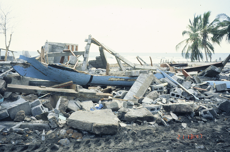
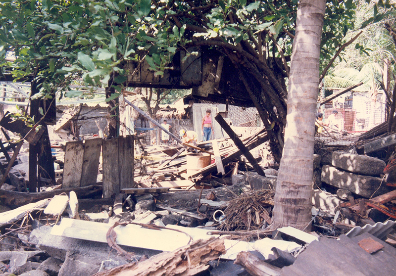
The earthquake and tsunami left at least 170 people dead, approximately 500 injured, and more than 13,500 homeless. The tsunami caused most of the damage.
Close to the source, many people also underestimated the magnitude of the earthquake on the basis of the shaking. Often, strong earthquake ground shaking serves as a natural warning sign of an impending tsunami, so that coastal communities can evacuate. But in this case the ground shaking was weak or soft. The source was only about 100 kilometers away, so why didn’t many coastal residents feel the earthquake, and why was the ensuing tsunami so high?
The unusual earthquake source characteristics and growing interest in tsunamis in the United States led to the organization of the first International Tsunami Survey Team (ITST) to document the tsunami’s effects. For the 25th anniversary of this event, we interviewed several Japanese and U.S. scientists involved with assessing the tsunami that followed this earthquake. From their accounts, we learned that ascertaining why coastal residents didn’t feel the earthquake greatly improved the ways scientists study tsunami generation and coordinate post-tsunami surveys today.
A Slowly Unrolling Earthquake
In a typical earthquake tsunami sequence, communities near the source feel the earthquake and, if properly alerted to their hazards, brace for the possibility of a tsunami. But the 1992 Nicaragua earthquake, which occurred on 2 September at 00:16 coordinated universal time (1 September at 19:16 local time), did not follow this typical pattern.
To understand what happened, one needs to look to a paper published 20 years prior to the events that preceded the 1992 Nicaragua tsunami. In 1972, Hiroo Kanamori, then at Japan’s Earthquake Research Institute of the University of Tokyo, proposed the term “tsunami earthquake“ [Kanamori, 1972]. In such earthquakes, fault rupture occurs more slowly and gradually than it normally would during a typical tectonic earthquake. Measurements of just the short-period seismic waves will not adequately capture this slow release of energy, so a tsunami triggered by such an earthquake is larger and runs up higher than one would expect from quick calculations of Ms.
Prior to 1992, scientists knew about tsunami earthquakes, but they hadn’t really observed seismograms where one unfolded or developed methods for quickly calculating a reliable magnitude when the largest energy is released later. The 1992 earthquake in Nicaragua changed that.
Newly developed broadband seismometers with digital acquisition systems enabled the tracking of the Nicaragua earthquake over multiple frequencies. The seismometers told an intriguing story: “We knew from our seismogram analysis that the source process was unusual, characterized by long duration,” Satake noted.
There it was: The first tsunami earthquake ever recorded by broadband seismometers [Kanamori and Kikuchi, 1993].
In this context, it made sense that many residents didn’t feel the ground shaking. The earthquake was slow, but it packed a big punch that triggered a destructive tsunami where none was expected [Satake, 1994].
The First International Tsunami Survey Team
The gradual release of energy during the 1992 Nicaragua earthquake resulted in underestimated early magnitude assessments because much of the energy was contained in longer-period waves. In 1992, PTWC calculated magnitudes using the 1-second short-period P waves and 20-second period surface waves. Thus, scientists did not know the Ms until 30 to 40 minutes after the earthquake, and when determined, it was below the tsunami warning threshold, recalled Laura Kong, who was on duty at PTWC for the event. As a result, the initial earthquake magnitude calculated did not tip off the scientific community about the possibility of a destructive tsunami.Because scientists were not tipped off, most of the world outside of Nicaragua heard about the tsunami through news media. Inside the country, however, Wilfried Strauch, a geophysicist at Nicaragua’s Instituto Nicaragüense de Estudios Territoriales (INETER), felt the long earthquake. After hearing on the radio about inundations along the coast, Strauch gathered his equipment and immediately left for the coast. Accompanied by the military, Strauch was among the first scientists and officials to confirm the tsunami’s destruction at sunrise.
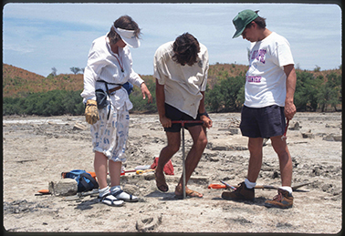
Intrigued, Imamura led one of the survey teams in Nicaragua’s affected areas. His and other teams joined a larger survey effort initiated by Kuniaki Abe (from Nippon Dental University College in Niigata, Japan) and Katsuaki Abe and Yoshinobu Tsuji (from the University of Tokyo’s Earthquake Research Institute, also in Japan). Upon hearing of the survey efforts, Satake contacted the U.S. National Science Foundation (NSF) to request permission to use grant funds to join the survey team in documenting this unusual tsunami. This request led Jody Bourgeois, a program officer at NSF at the time, to link up with the post-tsunami survey teams.

International Collaboration
Japan has a long history of tsunami events, and Japanese scientists had done extensive research on tsunami effects before the 1992 Nicaragua event. For instance, Satake was also part of a post-tsunami survey team that documented the 1983 Sea of Japan earthquake and tsunami.Japanese team members had a great deal of post-tsunami survey experience. In contrast, U.S. team members had little such previous experience. Although U.S. scientists surveyed the effects of the 28 March 1964 Alaska earthquake and tsunami, few destructive tsunamis had hit U.S. coasts in the decade leading up to the Nicaragua event. However, when the Nicaragua tsunami struck, there was growing interest in tsunamis among many U.S. scientists. Recent discoveries in the Cascadia Subduction Zone had revealed a tsunami that we now know struck in 1700, and many scientists were focused on reconstructing that event [Atwater, 1987].
Thus, leadership of the first ITST fell largely to Japanese scientists, given their prior tsunami experience in Japan. The Japanese members handled initial communications with Nicaraguans at INETER and benefited from previously established local connections.
However, as Frank Gonzalez, then an oceanographer at the NOAA Pacific Marine Environmental Laboratory (PMEL), recalled, the level of collaboration “was a first for everyone, so there was a lot of winging it and improvisation.”
One tricky problem to navigate was the availability and accuracy of baseline maps of the coastline. “The Nicaraguans supplied the Japanese team members with maps produced with the help of the Soviet Union,” Bourgeois recalled. “I had a set of maps produced by the U.S. government. The Nicaraguan set was more up to date from on-the-ground data because of cooperation between the Sandinista government and the U.S.S.R. We joked that the two sets were ‘KGB’ and ‘CIA.’”
Nonetheless, she noted that both sets of maps ultimately had issues with accuracy. One survey team member did have a GPS: It “was not very accurate, but then, neither were the maps,” Bourgeois said.
Results from the First ITST Survey
The ITST conducted its survey along more than 250 kilometers of the Nicaraguan coast. They determined the largest wave runups to be along the coast of central Nicaragua. The tsunami reached a height of 9.9 meters at El Tránsito (not 15 meters as reported in newspapers), decreasing to the north and remaining at 6 to 8 meters south to Bahía Marsella (Figure 1). These runup locations are stored in the NOAA National Centers for Environmental Information (NCEI)/World Data Service (WDS) Global Historical Tsunami Database [NCEI/WDS, 2017].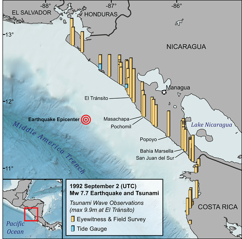

An Early Example of a Listserv
After the tsunami, Gonzalez and his team at PMEL developed what is now considered an Internet listserv. The forum, then called the Nicaragua Bulletin Board (or Tsu-Nica), was used to exchange data and manuscripts.Although these forums are common today, such a listserv was groundbreaking at the time. “It was the beginning of communication among tsunami scientists through the Internet,” Satake said.
This listserv continues today, now called the Tsunami Bulletin Board (TBB). Since 1995, the service has been hosted by the NOAA International Tsunami Information Center (ITIC). The TBB continues to be the main platform for sharing tsunami event information and coordinating post-tsunami surveys. Of course, Tsu-Nica did not solve all coordination and data-sharing problems, but it was an important first step.
Development of a Post-tsunami Survey Field Guide
Three years later, in June 1995, tsunami scientists from 10 countries participated in an International Tsunami Measurements workshop in Estes Park, Colo. This workshop started the development of a post-tsunami survey manual to provide guidance on conducting a survey, including logistics, techniques, and challenges.In 1998, ITIC and the United Nations Educational, Scientific and Cultural Organization’s Intergovernmental Oceanographic Commission (IOC) published the first edition of the Post-tsunami Survey Field Guide using experience gained from the Nicaragua ITST [IOC, 1998]. Much of the guidance included was based on the work of the first ITST in Nicaragua. For example, Japanese scientists “had a questionnaire which became the basis for future questionnaires,” noted Bourgeois, who attended the 1995 workshop.
The Legacy of the First Survey
The 1992 ITST focused on collecting water height, maximum inundation, and runup data. In the 25 years since this first survey, much has evolved. Bourgeois was the only sedimentary geologist on the 1992 ITST, but now post-tsunami surveys regularly survey geologic effects (e.g., deposits and erosion) of tsunamis. Social scientists, economists, ecologists, and engineers are now commonly involved in ITSTs. In addition, scientists are gathering eyewitness accounts from those who remember tsunamis that occurred in their childhoods, before modern instrumentation. All these efforts help communities better understand their long-term hazards.Reflecting on surveys then and now, Gonzalez remarked, “the tsunami community is now much more professionally diverse: not only engineers and oceanographers, but biologists, social scientists, etc. This is as it should be. Tsunamis know no borders, and no single profession can span all tsunami causes and effects.”
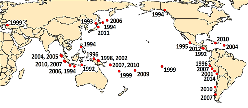
Since 1992, ITSTs have documented a total of 33 tsunami events in the Pacific and Indian oceans and the Caribbean and Mediterranean seas (Figure 2) [IOC, 2014]. To ensure easy access to data, the number of deaths, injuries, economic losses, and buildings damaged reported in ITSTs are now collected in the NCEI/WDS Global Historical Tsunami Database.
From Tragedy to Inspiration
The 1992 Nicaragua earthquake and tsunami were tragic events for the people of this Central American country. They brought to focus research on tsunami earthquakes, which remains a “blind spot on local tsunami warnings,” Satake noted. Through the earthquake’s analysis and first ever ITST, scientists took the first steps toward understanding these dangerous events.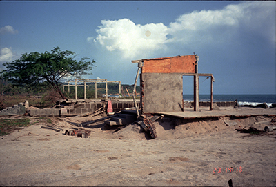
But perhaps the most enduring legacy of the 1992 Nicaragua earthquake and tsunami is their impact on how we now survey tsunamis. Post-tsunami surveys are now coordinated, interdisciplinary, international efforts. In some cases, the affected country may even request IOC and ITIC assist coordination efforts. The collection of perishable tsunami data has benefited from improved measurement capabilities (e.g., differential GPS and integrated laser range finders), leading to a better understanding of tsunamis. Moreover, the ITSTs have underscored to researchers the importance and duty of sharing data with one another through emerging technologies.
Better hazard management stems from coordinated scientific focus. The events 25 years ago in Nicaragua demonstrate this and serve as an enduring example of how collaboration yields information that may ultimately save lives.
Citation: Arcos, N., P. Dunbar, K. Stroker, and L. Kong (2017), The legacy of the 1992 Nicaragua tsunami, Eos, 98, https://doi.org/10.1029/2017EO080845. Published on 30 August 2017.
© 2017. The authors. CC BY-NC-ND 3.0
Keine Kommentare:
Kommentar veröffentlichen