
Inmarsat C
Inmarsat C provides two-way data and messaging communication services to and from virtually anywhere in the world. The low-cost terminals and antennas are small enough to be fitted to any size of ship.Safety communications using Inmarsat C
Inmarsat C is a two-way store and forward communication system that transmits messages in data packets in ship-to-shore, shore-to-ship and ship-to-ship direction.The equipment comprises a small omnidirectional antenna, compact transceiver (transmitter and receiver), messaging unit and, if GMDSS-compliant or with a distress function, a Dedicated Distress Button (DDB) to activate a Distress Alert.
Inmarsat Mini C terminals are the smallest models, with some incorporating the antenna and transceiver in the same above deck unit and, depending on the model, supporting the same communication services as Inmarsat C terminals.
All modern Inmarsat C and Mini C terminals have an integrated Global Navigational Satellite Services (GNSS) receiver for an automatic position update on the terminal, which is used for distress alerting (ship’s position, course and speed), ship’s position data reporting applications and selective reception of EGC SafetyNET messages.
Distress alerts and distress priority messages transmitted via the Inmarsat C system are routed through a Land Earth Station (LES) to a Maritime Rescue Co-ordination Centre (MRCC).
Inmarsat C coverage map

Distress alerting
Distress alerting is a mandatory service on SOLAS-compliant maritime Inmarsat C and Mini C terminals and on some non-SOLAS models too. Distress alerts are sent when a ship or crew is in grave and imminent danger.When there is no time to manually input information into the terminal, crew can simply press and hold down the DDB for approximately five seconds to transmit the alert. When the DDB is pressed, a short preformatted message including the vessel’s details and location is transmitted, with priority, from the terminal to an addressed LES that automatically routes it to an associated MRCC. The distress alert contains information on the terminal’s ID, addressed LES, date/time of alert, ship’s position, course, speed, time of last position update, nature of distress, flag and speed update.
When a distress alert is received by an MRCC, it will establish communication with the ship to organise search and rescue (SAR) services that may be required.
Enhanced Group Call
Inmarsat C and Mini C terminals can receive broadcast messages known as Enhanced Group Calls (EGC). EGC is the system for broadcasting Maritime Safety Information (MSI) and SAR- related information messages to Inmarsat C and Mini C terminals, and supports two services: SafetyNET and FleetNET.SafetyNET is the international service for the broadcast and automatic reception of maritime safety information (MSI) and SAR-related information via the Inmarsat EGC system.
SafetyNET receiving capability is part of the mandatory equipment required to be carried by certain ships in accordance with the provisions of the International Convention for the Safety of Life at Sea (SOLAS) 1974, as amended.
It is used by, but not limited to, NAVAREA co-ordinators for NAVAREA warnings and other urgent safety-related information; national coordinators for coastal warnings and other urgent safety-related information (the world’s oceans are divided into 21 geographical sea areas, called NAVAREAs in which various governments are responsible for navigation and weather warnings); METAREA issuing services for meteorological warnings and forecasts METAREAs are sea areas for weather forecast broadcast); and MRCCs for shore-to-ship distress alerts, SAR information and other urgent safety-related information.
SafetyNET messages can be directed to all ships in an entire ocean satellite region, to fixed NAVAREAs/METAREAs, to user-defined circular and rectangular addressed areas and to coastal areas with safety, urgency or distress priority. Reception of messages with urgency and distress priority will set off audial and visual alarms on the terminal and these messages will automatically be printed out on SOLAS-compliant terminals.
All ships navigating inside the addressed areas will receive MSI automatically. To receive costal warnings, ships’ terminals should be set up accordingly.


FleetNET is a commercial service and allows information to be sent to a virtually unlimited number of predesignated mobile terminals simultaneously, irrespective of their position. To receive EGC FleetNET messages, ships should have an Enhanced Data ID (ENID) downloaded into the terminal by a FleetNET service provider, using a poll command. The service may be used by shipping companies, organisations distributing news, commercial weather providers, etc.
Inmarsat C data reporting and polling services
The data reporting service allows Inmarsat C and Mini C terminals to send short data reports, up to four data packets, to a shore-based authority or operational centre.A typical data report could be a ship’s position report, sailing plan, or fisheries catch report – any data that can be encoded into data packets for the Inmarsat C system. One of the services to use data reporting and polling communication protocol is Long Range Identification and Tracking (LRIT) of ships, as required by the IMO.
Data reports may be sent from ships regularly, randomly or in response to a polling command from a shore-based operational centre. A typical polling command may instruct an Inmarsat C terminal to send a data report immediately or at a defined start time, with particular repetition intervals, to stop sending reports or to perform a defined task.
To transmit a data report, the MES should have Data Network ID (DNID) and Member number downloaded using polling command. Both are stored in the terminal’s memory.
http://www.inmarsat.com/services/safety/inmarsat-c/

Inmarsat-C

Inmarsat-C terminal (centre)
The service works with a store-and-forward method which enables interface with data network transfer including; e-mail; SMS; telex; remote monitoring; tracking (position reporting); chart and weather updates; maritime safety information (MSI); maritime security; GMDSS; and SafetyNET and FleetNET services; two-way messaging; data reporting and polling; Safety/Emergency alerting.
The service is operated via an Inmarsat-C Transceiver or a lower-power mini-C Transceiver. Data transfers between MES and LES at a rate of 600 bits/second. The frequencies for transmitting (TX) are 1626.5MHz -1645.5MHz and for receiving (RX) are 1530.0MHz - 1545.0MHz.
The service is available for maritime, land mobile and aeronautical use.
This system was also used to track the BBC's project "The Box".[2] BBC News followed a container around the world for a year to tell stories of globalization and the world economy.
Maritime Rescue Coordination Centers
The headquarters for Inmarsat C is located in London. The four Ocean Regions that are covered by Inmarsat C are:- the Atlantic Ocean Region East (AOR-E)
- Atlantic Ocean Region West (AOR-W)
- Pacific Ocean Region (POR)
- Indian Ocean Region (IOR).
- Wellington (New Zealand)-POR
- Aussaguel (France)-IOR/AOR-E/AOR-W
- Beijing (China)-IOR/POR
- Burum (The Netherlands)-AOR-E/AOR-W/IOR
- Elk (Norway)-AOR-E/AOR-W/IOR
- Emeq Haela (Israel)-AOR-E/IOR
- Fucino (Italy) AOR-E/IOR
- Ex Goonhilly @ Burum (Netherlands)
- Hai Phong (Vietnam)-IOR/POR
- Kumsan (S. Korea) IOR/POR
- Lakhadaria (Algeria) AOR-E
- Nakhodka (Russia)-POR
- Nudol (Russian Fed.)-AOR-E/IOR
- Perth (Australia)-IOR/POR
- Psary (Poland)-AOR-E/IOR
- Pune (India)-IOR
- Santa Paula (USA)-POR
- Sentosa (Singapore)-IOR/POR
- Southbury (USA)-AOR-E/AOR-W
- Tangua (Brazil)-AOR-E
- Thermopylae (Greece)-AOR-E
- Yamaguchi (Japan)-IOR/POR.
How to send a distress alert
When in a distress situation, your Mobile Earth Station is used to send out a distress alert. This distress alert is sent through a Land Earth Station, redirected to a land based Rescue Co-ordination Center (RCC). This will provide you with a communications link with yourself the RCC and Search and Rescue.Method 1
Using the distress menu on your GMDSS, follow these steps:- Enter your vessel's position, course, speed, and any other vital information onto the form displayed on the screen.
- Choose "Nature of Distress" from the toolbar list on top of the screen.
- Choose the closest LES to your ship's coordinates near your Ocean Region. You may select any LES within your particular Ocean Region.
- Using the distress button, send the alert by keeping it pressed for the required time (5 seconds).You should receive an acknowledgment from the LES within 5 minutes.
- If no acknowledgment from the LES, send another distress alert.
- After acknowledgment, further detailed information regarding the distress may be sent using the same method as above. This should be sent through the same LES as the original distress alert, this information will be sent to the same Rescue Co-ordination Center.
Method 2
There is usually little time to send a distress alert using the method above, therefore there is a quicker and simpler method:- Press and hold the distress button for the required time (5 seconds).
References
Tetley, Laurie; Calcutt, David (1994). Understanding GMDSS. Great Britain: British Library Cataloguing in Publication Data. pp. 178–179. ISBN 0-340-61042-5.Inmarsat C

Inmarsat-C-Anlage (mittlere Anlage)
Inmarsat C funktioniert digital und bietet folgende Kommunikationsmöglichkeiten:
- Telex
- Fax
- Datenübertragung (z. B. Internet)
Der Dienst wird über eine Inmarsat-C-Transceiver oder einen mini-C-Transceiver mit niedrigerem Stromverbrauch betrieben. Beide bieten den gleichen Service.
Da Inmarsat C mit einem mini-Transceiver auf relativ geringem Raum betrieben werden kann und Teil des GMDSS ist, ist das System auch für die Sportschifffahrt interessant.
Der Dienst steht für maritime, terrestrische und luftfahrttechnische Nutzung zur Verfügung.
Das Inmarsat-Satellitensystem
Autor:
namentlich nicht genannt
|
Inmarsat ist ein Globales Satelliten Kommunikationssystem mit dessen
Hilfe man in der Lage ist, von nahezu jedem Ort der Welt
(ausgenommen von den Polarkappen), eine Telefonverbindung über
geostationäre Satelliten herzustellen. Es kommt hauptsächlich zum
Einsatz auf Schiffen, Flugzeugen, Bohrinseln und anderen schwer
zugängigen Gebieten auf der Erde mit schlechter
Kommunikationsinfrastruktur. Momentan besteht das
Inmarsat-Satellitensystem aus 11 Satelliten, welche rund um den
Globus stationiert sind. Der Uplink zu den Satelliten liegt im
Bereich bei 1600 MHz im L-Band (mobile Terminals), sowie im Bereich
bei 5200 MHz im C-Band (feste Landstationen). Der Hauptdownlink ist
im L-Band und erstreckt sich von 1525-1550 MHz. Dieser
Frequenzbereich eignet sich sehr gut, da mit einer Wellenlänge von
20-cm, Atmosphäre, Wolken etc. problemlos durchdrungen werden
können. Auch im C-Band bei 3600 MHz senden die Satelliten. Doch
mittlerweile können dort scheinbar nur noch digitale bzw.
satelliteninterne Daten gehört werden. Früher waren dort die
Rückkanäle für Inmarsat-A Telefonverbindungen.
Bis Anfang 2008 war das am längsten in Betrieb gewesene analoge Inmarsat-A Verfahren noch in Betrieb. Sämtliche Kommunikation wurde dabei analog und unverschlüsselt übertragen. Zudem waren die Terminals noch ziemlich groß und unhandlich, da erst eine große Antenne aufgebaut und ausgerichtet werden musste. Nun nutzt man andere digitale Systeme, die effektiver mit kleinerer Technik und schmaleren Bandbreiten meist eine bessere Gesprächsqualität bieten, wie z.B. das Inmarsat-B. Das Inmarsat-B ist praktisch der Nachfolger von Inmarsat-A, welches hauptsächlich für Sprachtelefonate und Fax, aber auch für Internet genutzt werden kann. Dieses arbeitet nicht mehr analog, sondern bietet bereits digitale Sprachübertragung und ist GMDSS kompatibel. Das Inmarsat-C ist ebenfalls ein digitales Übertragungsverfahren, das hauptsächlich bei der Versendung von Daten und Nachrichten, wie auch E-Mails genutzt wird. Auch besonders Wettermeldungen und Warnungen (GMDSS) können damit an Schiffe auf dem Meer übertragen werden. Ebenfalls ist es möglich einen Notruf über dieses System abzugeben. Das Equipment ist relativ klein und passt meist in einen Aktenkoffer. Diese Nachrichten können auch recht einfach mit entsprechender Software dekodiert werden. Jedes größere hochseetaugliche Schiff ist heutzutage verpflichtet dieses System mit an Board zu führen. Das Inmarsat-D ist ein digitales Pager-Verfahren und bietet ähnliche Dienste wie Inmarsat-C an. Unter anderem ist es auch für die Positionsverfolgung von Objekten konzipiert. So kann man beispielsweise ein einzelnes Schiff oder ganzen Flotten von Schiffen auf dem Meer verfolgen. Inmarsat-E war für den Empfang von Notrufsignalen zuständig, die von Notruffunkbaken ausgesendet wurden. Diese Signale wurden dann über Inmarsat an eine Bodenstation weitergeleitet. Dies wurde allerdings am 1. Dezember 2006 eingestellt. Nun helfen meist SARSAT Nutzlasten an geostationären Satelliten, wie MSG-1/2 und Goes, sowie an Satelliten im Low Earth Orbit wie den NOAA's, der Weiterleitung von Notrufsignalen. Dann gibt es noch das Inmarsat-M und Mini-M, beide kommen heutzutage hauptsächlich bei der Sprachkommunikation zum Einsatz. Das Inmarsat-M wird vom Global Beam der Inmarsat's bedient, daher müssen die Sende- und Empfangsantennen noch recht groß sein. Inmarsat-Mini M nutzt viele einzelne Spot Beams, was den Vorteil hat, dass die Terminals klein sind und meist das komplette Equipment inklusive Antenne in einen Aktenkoffer passt. Inmarsat-M nutzt ein IMBE Sprach-Codec. Ein ähnliches AMBE Sprach-Codec kommt z.B. auch bei D-Star zum Einsatz. Es könnte möglich sein, mithilfe eines DV-Dongle den passenden Sprach-Codec zu dekodieren. Zur Zeit sind aber nur sehr wenig Informationen über das genutzte Codec bei Inmarsat-M vorhanden. (Jegliche Informationen dazu sind immer willkommen!) Auch bei der NASA wird Inmarsat genutzt. Während eines Space Shuttle Starts werden damit wichtige Telefonverbindung zu den Transoceanic Abort Landing Sites (TAL's) hergestellt. Wie z.B. zu den USAF Flughäfen Zaragoza und Moron in Spanien, sowie Istress in Frankreich. Dabei werden Konferenzschaltungen eingerichtet, woran auch das MCC in Houston und das KSC in Florida dran teilnehmen und start relevante Informationen mit den TAL's austauschen. Bis zum Sommer 2007 wurde dafür das analoge Inmarsat-A System genutzt. Seitdem ist man wahrscheinlich auf ein IP-Phone ähnliches digitales Verfahren umgestiegen, welches vermutlich BGAN (ein Breitband Datendienst von Inmarsat) nutzt. Inmarsat kommt aber nach wie vor bei Space Shuttle Starts zum Einsatz. Welches Empfangs-Equipment wird benötigt um Inmarsat-C zu empfangen ? Als erstes braucht man einen entsprechenden Empfänger, der Inmarsat im L-Band zwischen 1530-1545 MHz empfangen kann. Dieser Empfänger muß die Modulationsart SSB (USB/LSB) unterstützen und möglichst kleine Frequenzschritte beherrschen. Als zweites benötigt man eine geeignete Antenne und Vorverstärker. Optimal geeignet und recht weit verbreitet sind Wendel-Antennen (Helical-Antennen). Diese gibt es in Versionen mit wenigen bis vielen Windungen. Man kann die Wedel-Antenne direkt auf den Satelliten ausrichten. Allerdings benötigt man dann eine relativ lange Antenne mit recht vielen Windungen, um den erforderlichen Gewinn zu erzielen. (Allerdings waren Tests mit einer Wendel-Antenne mit nur 5 Windungen, einen gut abgestimmten Vorverstärker und empfindlichen Empfänger ebenfalls erfolgreich.) Einfacher ist es meist eine Parabol-Antenne zu verwenden. Minimum ist dabei ca. 60 cm Durchmesser. An dieser wird eine kurze Wendel-Antenne mit max. 3 Windungen im Brennpunkt installiert. Die Signale werden RHCP also rechtsdrehend zirkular polarisiert vom Satelliten abgestrahlt, daher müssen lange Wendel-Antennen ohne Reflektor auch rechtsrum gedreht sein. Wenn man einen Reflektor zum Empfang nutzt, wird das Signal gespiegelt. Aus dem Grund muß die kurze Wendel-Antenne, als Erreger in einer Parabol-Antenne LHCP linksdrehend angebracht sein. Man sollte drauf achten möglichst rauscharme Vorverstärker zu verwenden. Angeboten wird z.B. der ULNA3013 von tgn oder der KU LNA 152 AH von KUHNE electronic. Ebenfalls sollte nach Möglichkeit auch dämpfungsarmes Antennenkabel zum Einsatz kommen. |
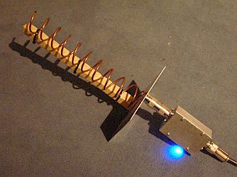 L-Band Wendel-Antenne mit 10 Windungen |
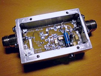 L-Band Vorverstärker (LNA) |
Welche Software gibt es
für die Dekodierung der Signale ?Als nächstes
muss das Audiosignal des Empfängers mit dem Line-In-Eingang eines
PC's verbunden werden. Nun braucht man nur noch die entsprechende
Dekodiersoftware. Zum einen wird dort
Code300-32 von Hoka Electronic
angeboten. Allerdings ist dies auch ein Dekoder für viele andere
Betriebsarten und daher auch entsprechend teuer. Eine reine Inmarsat std-C Dekodiersoftware gibt es z.B. als ein
DOS-Programm von Jakub Hruska bei Inmarsatdecoder.com. Zum Download
wird dort nur im Moment eine kostenlose Testversion angeboten,
womit man die EGC's (Enhanced Group Calls) auf den NCS (Network
Control Station) Kanälen dekodieren kann. (Mehr dazu später.) Alex
Scafidas bietet ebenfalls eine reine
Inmarsat std-c auf Java basierende Dekodiersoftware an, welche
Freeware ist und auch die EGC's auf den NCS Kanälen dekodieren kann.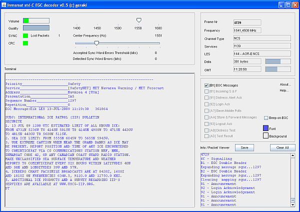 Welcher der Inmarsat Satelliten kommt für mich in Frage zu empfangen ? Inmarsat-C steht in den folgenden Satellitenregionen zur Verfügung.: AOR-W (Atlantischer Ozean West), AOR-E (Atlantischer Ozean Ost), IOR (Indischer Ozean) und POR (Pazifischer Ozean). Für Europa ist die AOR-E Region mit dem Inmarsat 3-F2 am besten zu empfangen. Dieser Satellit befindet sich auf der geostationären Position von 15,5° West. Für Deutschland wäre das z.B. ca. 210° Azimut und 28° Elevation. Wann und auf welcher Frequenz kann ich Inmarsat-C empfangen ? Inmarsat-C sendet standardmäßig rund um die Uhr im Frequenzbereich zwischen 1530-1545 MHz. Es gibt diverse schmalbandige TDMA Kanäle, welche alle mit 1200bps BPSK arbeiten. Eine ständig aktualisierte Liste findet man auf UHF-Satcom.com der Seite von Paul Marsh. Die NCS (Network Control Station) Kanäle sind in den folgenden Regionen/Satelliten zu empfangen: |
| Region | Position | Frequenz |
| AOR-W | 54,0° West | 1537.700 MHz |
| AOR-E | 15,5° West | 1541.450 MHz |
| IOR | 64,5° Ost | 1537.100 MHz |
| POR | 178,0° Ost | 1541.450 MHz |
| Auf den NCS Kanälen können im paar minütigem Abstand die bereits erwähnten EGC's, mit Navigations- und Wettermeldungen für die Luft- und Seefahrt empfangen und dekodiert werden. |
 Ein NCS-Test über AOR-E. |
|
Einrichten der Hard und Software für die
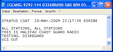
Dekodierung Die Antenne sollte auf einen der Inmarsat Satelliten ausgerichtet sein. Zum genauen Ausrichten der Antenne bietet sich eines der TDMA Signale gut an, da diese standardmäßig rund um die Uhr senden. Sobald die Antenne korrekt eingestellt ist und man ein deutliches Datenrauschen des TDMA Kanals in USB hören kann, sollte man spätestens jetzt den Empfänger mit der Soundkarte des PC´s verbinden. Nun kann die Dekodiersoftware gestartet werden. Es sollte die richtige Soundkarte ausgewählt sein und der Audiopegel gut justiert werden. Normalerweise muß der Empfänger in USB ca. 2,2 kHz unter der Mittenfrequenz auf das untere Seitenband gestimmt werden. Das ist aber Empfängerunterschiedlich und muss ausprobiert werden. Auch beachtet werden sollte, dass der Empfänger frequenzstabil ist. Oft müssen die Filter erst "warm werden" um sich auf eine Frequenz einzuschwingen. Wenn der Empfänger auf die richtige Frequenz eingestellt ist und alle anderen Einstellungen ebenfalls korrekt sind, sollte nun der Wert bei QUAL (Qualität des Signals) ansteigen und die ersten Kanalparameter des ausgewählten Kanals dekodiert in dem Fenster angezeigt werden. Nicht aufgeben, wenn es beim ersten Versuch nicht gleich klappt. Wenn es hier Probleme gibt, sind auch viele Tipps in der Hilfe/Readme Datei der Software zu finden. Alle empfangenen Nachrichten werden automatisch im Fenster angezeigt und zusätzlich in eine TXT-Datei im installierten Ordner exportiert. letzte Änderung: 27.08.2012 http://www.satellitenwelt.de/inmarsat.htm ########################################### http://weather.gmdss.org/index.html GLOSSARY, ACRONYMS AND OTHER ABBREVIATIONS
Metarea SCHEDULE
TRANSMISSION SCHEDULES FOR GMDSS SAFETYNET SERVICES
| ||||||||||||||||||||||||||||||||||||||||||||||||||||||||||||||||||||||||||||||||||||||||||||||||||||||||||||||||||||||||||||||||||||||||||||||||||||||||||||||||||||||||||||||||||||||||||||||||||||||||||||||||||||||||||||||||||||||||||||||||||||||||||||||||||||||||||||||||||||||||||||||||||||||||||||||||||||||||||||||||||||||||||||||||||||||||||||||||||||||||||||||||||||||||||||||
| METAREA | Meteorological Issuing Service | Satellite Ocean Regions | Broadcast schedule (UTC) | |||||
| I | United Kingdom | AOR (E) | 0930 | 2130 | ||||
| II | France | AOR (E) AOR (W) | 1015 1015 | 2215 2215 | ||||
| III | Greece1 | AOR (E ) | 1000 | 2200 | ||||
| IV | USA | AOR (W) | 0430 | 1030 | 1630 | 2230 | ||
| V | Brazil | AOR (E) | 0730 | 1930 | ||||
| VI | Argentina | AOR (W) | 0230 | 1730 | ||||
| VII west of 20E | South Africa | AOR (E) | 0940 | 1940 | ||||
| VII east of 20E | South Africa2 | IOR | 0940 | 1940 | ||||
| VIII (N) (north of equator) | India | IOR | 0900 | 1800 | ||||
| VIII (S) (south of equator) | Mauritius / La Réunion (via France) | IOR | 0130 00003 | 06003 | 1330 12003 | 18003 | ||
| IX | Pakistan | IOR | 0700 | |||||
| X IOR | Australia | IOR | 04306 (WA coast) | 1030 | 16306 (WA coast) | 2330 | ||
| X POR | Australia | POR | 05104 (Bass Strait only) | 08155 (NT coast) | 1100 | 17004 (Bass Strait only) | 20155 (NT coast) 2300 | |
| XI IOR | China (for IOR) | IOR | 0330 | 1015 | 1530 | 2215 | ||
| XI POR | Japan (for POR)7 | POR north of equator south of equator | 0230 | 0830 0815 | 1430 | 2030 2015 | ||
| XII | USA | POR AOR (W) | 0545 | 1145 | 1745 | 2345 | ||
| XIII | Russian Federation | POR | 0930 | 2130 | ||||
| XIV | New Zealand | POR | 01304 (NZ coast only) 0330 (warnings only) | 0930 | 13304 (NZ coast only) 1530 (warnings only) | 2130 | ||
| XV | Chile | AOR (W) | 1845 | |||||
| XVI | USA | AOR (W) | 0515 | 1115 | 1715 | 2315 | ||
| XVII | Canada | POR | 0300 | 1500 | ||||
| XVIII | Canada | AOR (W) | 0300 | 1500 | ||||
| XIX | Norway | AOR (E) | 1100 | 2300 | ||||
| XX | Russian Federation | IOR | 0600 | 1800 | ||||
| XXI | Russian Federation | POR | 0600 | 1800 | ||||
| 1Scheduled bulletins and warnings for the western Mediterranean Sea are prepared by France 2Forecast for area 30°S-50°E / 50°S-80°E and tropical cyclone warnings are prepared by La Réunion 3Tropical Cyclone warnings if any issued by La Réunion as unscheduled broadcasts 4Local time. The Bass Strait bulletins are Coastal Warnings and Forecasts transmitted only to SafetyNET Coastal Area D in Navarea X 5Northern Territory bulletins are Coastal Warnings and Forecasts transmitted only to SafetyNET Coastal Areas G and H in Navarea X 6Local time. Western Australia bulletins are Coastal Warnings and Forecasts transmitted only to SafetyNET Coastal Areas F and G in Navarea X 7Scheduled bulletins and warnings for south of the equator prepared by Australia For unscheduled broadcasts, these shall be issued for broadcast under the SafetyNET service through all Inmarsat ocean region satellites covering the issuing service's area of responsibility. | ||||||||

METAREA VII
METAREA VIII_N
METAREA VIII_S
METAREA IX
METAREA X
METAREA XI
METAREA XI : The Indian Ocean, China Sea and North Pacific Ocean northward of Area X and on the equator to longitude 180°, eastward of Area VIII and the Asian continent to the North Korea/Russian Federation frontier in 42°30'N 130°E, thence to 135°E, NE_wards to 45°N 138°E, to 45°N 180°
| Issuing Service China Japan | Preparation Service Australia (south of the equator) | Satellite Ocean Regions (scheduled bulletins) IOR (China) POR (Japan) |
| Warnings, if any, included in scheduled messages (China) | ||
METAREA messages | ||||||||||||
| ||||||||||||
NAVTEX messages | Choose a coastal NAVTEX station in the list below |
| China : Guangzhou [N], Shanghai [Q], Tianjin [S] Japan : Kushiro [K], Moji [H], Naha [G], Otaru [J], Yokohama [I] USA : Marianas [V] | |
| China National Meteorological Service Website Hong-Kong China Meteorological Service Website Japan National Meteorological Service Website | General information (including maps) |
METAREA X : The South Indian Ocean and Southern Oceans east of 80°E and south of 30°S, to 95°E, to 12°S, to 127°E and thence to the Timor Sea, South Pacific and Southern Oceans south of 10°S to 141°E, to the Equator, to 170°E, to 29°S, thence south-westward to 45°S at 160°E and then to the meridian at 160°E.
| Issuing Service Australia | Preparation Service Papua New Guinea | Satellite Ocean Regions (scheduled bulletins) IOR POR |
|
| Australia National Meteorological Service Website | General information (including maps) |
METAREA IX : The Red Sea, Gulf of Aden, Arabian Sea and Persian Gulf, north of Area VIII
| Issuing Service Pakistan | Satellite Ocean Regions (scheduled bulletins) IOR |
| Warnings, if any, included in scheduled messages | |
|
| Pakistan National Meteorological Service Website | General information (including maps) |
METAREA VIII S : The east African coast from the equator south to 10°30'S, thence to 55°E, to 30°S, to 95°E, to the equator, to the east African coast
| Issuing Service Mauritius (Scheduled forecast) La Reunion (Tropical Cyclone Warning) Australia (Tropical Cyclone Warning East of 90E) | Satellite Ocean Regions (scheduled bulletins) IOR |
| For tropical cyclone warning East of 90°E, see Metarea 10 (Perth) | |
|
| Mauritius National Meteorological Service Website French National Meteorological Service Website Australia National Meteorological Service Website | General information (including maps) |
METAREA VIII N : The area of the Indian Ocean enclosed by lines from the Indo-Pakistan frontier in 23°45'N 68°E to 12°N 63°E, thence to Cape Gardafui; the east African coast south to the equator, thence to 95°E, to 6°N, thence NE_wards to the Myanmar/Thailand frontier in 10N 98°30'E
| Issuing Service India | Satellite Ocean Regions (scheduled bulletins) IOR |
|
| Indian National Meteorological Service Website | General information (including maps) |
METAREA VII : The
South Atlantic and Southern Oceans south of 6°S from 20°W to the coast
of Africa, thence south to the Cape of Good Hope; the South Indian and
Southern Oceans south of 10°30'S from the Cape to 55°E, thence south of
30°S to 80°E
| |||||||||||||||||
Keine Kommentare:
Kommentar veröffentlichen